
7.1.1 Coastal plains with ridges and dunefields (Brighton, Cranbourne)
7. Eastern Plains (EP)
7.1 Central Sunklands
| The coastal plains with ridges and dunes which are typified in the Brighton, Cranbourne and Tyabb areas are formed over Neogene sediments, generally mantled by a layer of sand of variable thickness. The series of low parallel northwest trending dune ridges that lie parallel to the present coastline are believed to represent stranded Neogene dune ridges or former coastlines. The soils are either acidic sandy texture contrast soils (Chromosols) or deep, strongly acid sands with bleached subsoil and a hard, dark brown “B” horizon of “coffee rock” at about 0.8 m, composed of organic matter and aluminium and/or iron compounds (Podosols). The present climate is humid to sub-humid, with rainfall generally well distributed over the year. The original vegetation is believed to be grassy woodland/damp sands herb-rich woodland mosaic with areas of heathy woodland/heathy herb-rich woodland mosaic. Remnants of the older vegetation on the acidic sands may be seen at the Botanical Reserve south of Cranbourne. Most of the area is now subdivided for housing or used for recreation, mainly golf courses. Earlier the area was renowned for its market gardens. The former sand quarries that supplied Melbourne with sand are located within this area and now serve as landfill sites. | 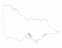 |
© State of Victoria (Agriculture Victoria) 1996 - .

This work, Victorian Resources Online, is licensed under a Creative Commons Attribution 4.0 licence. You are free to re-use the work under that licence, on the condition that you credit the State of Victoria (Agriculture Victoria) as author, indicate if changes were made and comply with the other licence terms.
The licence does not apply to ‘branding’ or some ‘images or photographs’ that may be owned by third parties. We ask you to seek prior approval to use images using the VRO feedback form. Access to higher quality images can also be provided on request.
This page was last updated on .