
B 3.5 Plains and Rises, Recent sediments, Type 1
PgKm1, PCuKm1, PRguKFm1, PRuKm1, PRuKFm1, RuKFm1, RPguKm1, RPuKm1, RgKm1, RgKh1, RuKm1, RrKm1, RCgKFm1
Soils: Uc, Dy Multi-layered soil profiles often with a sandy component throughout the profile. The A horizons consist of sandy loam surface horizon with variable amounts of organic matter, decreasing down the profile (sandy texture). At variable depths the incoherent sand sharply overlies a dark sandy humic pan, usually massive and usually about 30 cm in depth. This may overly a sandy (yellow) horizon or a layer with a higher clay content (clayey sand, marl). Profiles where the lighter (i.e. sandy) upper horizons are greater than 1.0 m depth are generally denoted as Uniform. For soil properties such as drainage and permeability, a knowledge of the soil profile is essential.
Native Vegetation: The native vegetation consists of Lowland Sclerophyll Forest, Coastal Sclerophyll Forest, Coastal Banksia Woodland and Coastal Heath. The latter is particularly associated with areas of plant stress i.e. susceptible to waterlogging, wind erosion and moisture deficit stress. The species include White Stringybark (E. globoidea), Silvertop (E. sieberi), Yertchuk (E. consideniana), Southern Mahogany, Coast Banksia, Saw Banksia, Sunshine Wattle (Acacia terminalis), Sallow Wattle (A. longifolia), Prickly Tea-tree (Leptospernum juniperinium), Scented Paper-bark (M. squarrosa) and Spear Grass-tree (Xanthorrhea resinosa).
Stone/rock outcrop: Nil.
Pans: Nil or not observed.
Land use: Some of these areas have been cleared generally for grazing or other uses including an aerodrome, tip, caravan park and a marl pit. Recreation is another major use of the area as well as conservation in the Croajingalong National Park (most of the area within these units) which includes an education area.
Observed land use deterioration: minor sheet and wind erosion.
Susceptibility to land deterioration: Sheet and rill erosion (very low to moderately high); Gully erosion (low to moderate); Compaction (low to moderate); Inundation/Waterlogging (low to moderately high); Mass movement (low); Wind erosion (low to moderately high).
Sites with laboratory data: 166.
Page top
| These map units are associated with unconsolidated Quaternary sediments, predominantly sands but with numerous occurrences of silts, clays and marl. The topography consists of low dune and depression (swale) sequences, broad plain units and shallow drainage depressions. These units are associated with the coastal areas of the region, located behind the foreshore dunes and south of the Tertiary deposits. The soils tend to have uniform (coarse) and duplex profiles with sandy surfaces and often with a humic or siliceous pan at variable depth. The native vegetation consists of Lowland Sclerophyll Forest, Coastal Sclerophyll Forest, Coastal Banksia Woodland, Banksia Woodland and Coastal Heath. Geology: Qra, Qrc, Qrp Recent (Quaternary) alluvium. Gravel, sand, silt, clay and marl. Rainfall: 700-1000 mm per annum. Slope: 0-10%, often less than 3%. Dominant landform element: Plain, rise. Minor landform element: Drainage depression, open depression. | 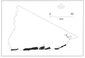 |
Soils: Uc, Dy Multi-layered soil profiles often with a sandy component throughout the profile. The A horizons consist of sandy loam surface horizon with variable amounts of organic matter, decreasing down the profile (sandy texture). At variable depths the incoherent sand sharply overlies a dark sandy humic pan, usually massive and usually about 30 cm in depth. This may overly a sandy (yellow) horizon or a layer with a higher clay content (clayey sand, marl). Profiles where the lighter (i.e. sandy) upper horizons are greater than 1.0 m depth are generally denoted as Uniform. For soil properties such as drainage and permeability, a knowledge of the soil profile is essential.
Native Vegetation: The native vegetation consists of Lowland Sclerophyll Forest, Coastal Sclerophyll Forest, Coastal Banksia Woodland and Coastal Heath. The latter is particularly associated with areas of plant stress i.e. susceptible to waterlogging, wind erosion and moisture deficit stress. The species include White Stringybark (E. globoidea), Silvertop (E. sieberi), Yertchuk (E. consideniana), Southern Mahogany, Coast Banksia, Saw Banksia, Sunshine Wattle (Acacia terminalis), Sallow Wattle (A. longifolia), Prickly Tea-tree (Leptospernum juniperinium), Scented Paper-bark (M. squarrosa) and Spear Grass-tree (Xanthorrhea resinosa).
Stone/rock outcrop: Nil.
Pans: Nil or not observed.
Land use: Some of these areas have been cleared generally for grazing or other uses including an aerodrome, tip, caravan park and a marl pit. Recreation is another major use of the area as well as conservation in the Croajingalong National Park (most of the area within these units) which includes an education area.
Observed land use deterioration: minor sheet and wind erosion.
Susceptibility to land deterioration: Sheet and rill erosion (very low to moderately high); Gully erosion (low to moderate); Compaction (low to moderate); Inundation/Waterlogging (low to moderately high); Mass movement (low); Wind erosion (low to moderately high).
Sites with laboratory data: 166.
© State of Victoria (Agriculture Victoria) 1996 - .

This work, Victorian Resources Online, is licensed under a Creative Commons Attribution 4.0 licence. You are free to re-use the work under that licence, on the condition that you credit the State of Victoria (Agriculture Victoria) as author, indicate if changes were made and comply with the other licence terms.
The licence does not apply to ‘branding’ or some ‘images or photographs’ that may be owned by third parties. We ask you to seek prior approval to use images using the VRO feedback form. Access to higher quality images can also be provided on request.
This page was last updated on .