
B 3.4 Plains, Alluvial, Type 2
PlgAm2, PlgAh2
Soils: Dominant: Dy3.11, Gn3.91. Strongly structured, friable, deep alluvial profile with distinctive horizon development but variable textural trends throughout the profile (gradational or duplex). Dark organic matter rich A horizons (silty loams) over a yellowish brown B horizon (silty clay loam to silty clay), with some yellow/orange mottling.
Minor: Um Silty profile, deep and uniform texture gradient often with a denser (clay) layer at depth; associated with stream banks, levees.
Native vegetation: Cleared with some remnants of native vegetation. Probable vegetation cover included Dry Sclerophyll Forest, Riparian Forest and Warm Temperate Rainforest: Gippsland Grey Box (E. bosistana) was a dominant species.
Stone/rock outcrop: Nil, apart from specific gravel lenses.
Pans: Nil or not observed.
Land use: Cleared for pasture production, primarily for dairy and beef production. Some market gardening and other small holdings.
Observed land deterioration: Some bank erosion, severe in places.
Susceptibility to land deterioration: Sheet and rill erosion (very low to moderate); Gully erosion (very low to moderate); Compaction (very low to high); Inundation/Waterlogging (moderately low to very high); Mass movement (very low to moderately low).
Sites with laboratory data: 17, 143.
Page top
| Theses units occupy the Cann River Valley floodplain which extends from about 2.5 km south of Cann River township and northwards to Noorinbee North. This floodplain complex is made up of Recent (Quaternary) alluvium and includes levees, floodplains, terraces and previous water course alignments (meanders, ox-bow lakes). It should be noted that the Cann River has been diverted and straightened to reduce flooding for the local farmers. This has resulted in the objective being achieved but at a cost of an incised river, causing increased bank erosion and increased sediment loads. The soils range from uniform silts along the river bank and previous courses to duplex profiles (yellow and brown). The native vegetation has been cleared but the surrounding vegetation is Lowland Sclerophyll Forest. Prior to clearing, Riparian Forest dominated by Gippsland Grey Box (E. bosistana) and Warm Temperate Forest generally occurred on these units. Geology: Qra; Recent(Quaternary) alluvium. Sand, gravel, silt and clay. Rainfall: 700-1200 mm per annum, generally 700-1000 mm per annum. Slope: 0-3%. Dominant landform element: Plain, open depression. Minor landform element: Drainage depression. | 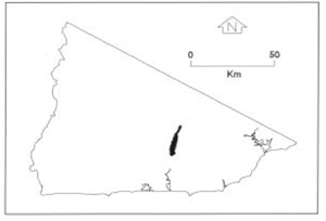 |
Soils: Dominant: Dy3.11, Gn3.91. Strongly structured, friable, deep alluvial profile with distinctive horizon development but variable textural trends throughout the profile (gradational or duplex). Dark organic matter rich A horizons (silty loams) over a yellowish brown B horizon (silty clay loam to silty clay), with some yellow/orange mottling.
Minor: Um Silty profile, deep and uniform texture gradient often with a denser (clay) layer at depth; associated with stream banks, levees.
Native vegetation: Cleared with some remnants of native vegetation. Probable vegetation cover included Dry Sclerophyll Forest, Riparian Forest and Warm Temperate Rainforest: Gippsland Grey Box (E. bosistana) was a dominant species.
Stone/rock outcrop: Nil, apart from specific gravel lenses.
Pans: Nil or not observed.
Land use: Cleared for pasture production, primarily for dairy and beef production. Some market gardening and other small holdings.
Observed land deterioration: Some bank erosion, severe in places.
Susceptibility to land deterioration: Sheet and rill erosion (very low to moderate); Gully erosion (very low to moderate); Compaction (very low to high); Inundation/Waterlogging (moderately low to very high); Mass movement (very low to moderately low).
Sites with laboratory data: 17, 143.
© State of Victoria (Agriculture Victoria) 1996 - .

This work, Victorian Resources Online, is licensed under a Creative Commons Attribution 4.0 licence. You are free to re-use the work under that licence, on the condition that you credit the State of Victoria (Agriculture Victoria) as author, indicate if changes were made and comply with the other licence terms.
The licence does not apply to ‘branding’ or some ‘images or photographs’ that may be owned by third parties. We ask you to seek prior approval to use images using the VRO feedback form. Access to higher quality images can also be provided on request.
This page was last updated on .