
B 3.10 Low hills and Hills, Granitic, Type 3
LuGm3, LuGh3, LrGm3, LrGh3, HrGm3, HrGh3, HrGv3, HsGh3, LrGKm1, PgAm0, PgAh0
Soils: Dominant: Dr2, Db1, Gn4, Gn2. Red duplex soils with sandy A horizons (loamy coarse sand) and clayey, moderately structured subsoils (sandy clay loam) with coarse material throughout. The development of soil profiles on these units are dependent on topographic position and/or vicinity of hard rock outcrop (shallow profiles and less developed). Drier sites have more duplex characteristics such as a more marked change between A and B horizons and less friable subsoils and more yellow in colour. Gradational profiles are more likely in the moister areas and can be deep to very deep on weathered colluvial slopes, for example, around gully heads and drainage lines.
Native vegetation: Dry and Wet Sclerophyll Forest predominantly depending on aspect and topographic position, with Warm Temperate Rainforest in many of the drainage lines and drainage depressions. Mixed Species, predominantly White Stringybark and Silvertop associations dominate the drier aspects and topographic positions. Gums and other eucalypts are in more moist situations: Mountain Grey Gum (E. cypellocarpa) in drainage lines, and Manna Gum (E. viminalis), Lilly-pilly (Eugenia smithii) and Blackwood (A. melanoxylon) with typical rainforest.
Stone/rock outcrop: Minor; predominantly Mt. Drummer.
Pans: Generally nil; occasional pan in weathered parent material.
Land use: Most of these units are forested, predominantly State Forest and available for hardwood production, or they are within the Alfred National Park.
Observed land deterioration: Sheet and rill erosion, some batter slumping.
Susceptibility to land deterioration: Sheet and rill erosion (moderately low to very high); Gully erosion (low to high); Compaction (low to moderately high); Inundation/Waterlogging (low to high); Mass movement (low to high).
Sites with laboratory data: 178.
Page top
| These are undulating and rolling low hill and hill units associated with a granodiorite pluton featuring Mt. Drummer. While there may be some minor steep slopes associated with these units around Mt. Drummer there is insufficient relative relief (>300m) to technically describe an appropriate unit as a mountain. The area to the north of Mt. Drummer has lower slopes and there are some friable reddish soils (particularly the subsoil) associated with the middle, lower slopes and higher rainfall zones. The vegetation is predominantly Lowland Sclerophyll Forest, while in the broad drainage depressions and upper gullies there is Warm Temperature Rainforest, some of which is preserved within the Alfred National Park. Geology: Dgl3; Devonian Granodiorite (Drummer Granodiorite). Rainfall: 700 - greater than 1200 mm per annum, generally 1000-1200 mm per annum. Slope: Variable, 3-32%, generally 10-32%. Dominant landform element: Slope. Minor landform element: Crest, drainage depression. | 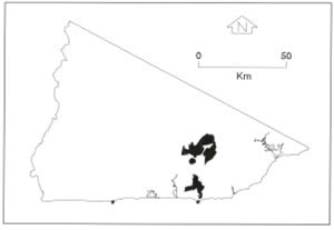 |
Soils: Dominant: Dr2, Db1, Gn4, Gn2. Red duplex soils with sandy A horizons (loamy coarse sand) and clayey, moderately structured subsoils (sandy clay loam) with coarse material throughout. The development of soil profiles on these units are dependent on topographic position and/or vicinity of hard rock outcrop (shallow profiles and less developed). Drier sites have more duplex characteristics such as a more marked change between A and B horizons and less friable subsoils and more yellow in colour. Gradational profiles are more likely in the moister areas and can be deep to very deep on weathered colluvial slopes, for example, around gully heads and drainage lines.
Native vegetation: Dry and Wet Sclerophyll Forest predominantly depending on aspect and topographic position, with Warm Temperate Rainforest in many of the drainage lines and drainage depressions. Mixed Species, predominantly White Stringybark and Silvertop associations dominate the drier aspects and topographic positions. Gums and other eucalypts are in more moist situations: Mountain Grey Gum (E. cypellocarpa) in drainage lines, and Manna Gum (E. viminalis), Lilly-pilly (Eugenia smithii) and Blackwood (A. melanoxylon) with typical rainforest.
Stone/rock outcrop: Minor; predominantly Mt. Drummer.
Pans: Generally nil; occasional pan in weathered parent material.
Land use: Most of these units are forested, predominantly State Forest and available for hardwood production, or they are within the Alfred National Park.
Observed land deterioration: Sheet and rill erosion, some batter slumping.
Susceptibility to land deterioration: Sheet and rill erosion (moderately low to very high); Gully erosion (low to high); Compaction (low to moderately high); Inundation/Waterlogging (low to high); Mass movement (low to high).
Sites with laboratory data: 178.
© State of Victoria (Agriculture Victoria) 1996 - .

This work, Victorian Resources Online, is licensed under a Creative Commons Attribution 4.0 licence. You are free to re-use the work under that licence, on the condition that you credit the State of Victoria (Agriculture Victoria) as author, indicate if changes were made and comply with the other licence terms.
The licence does not apply to ‘branding’ or some ‘images or photographs’ that may be owned by third parties. We ask you to seek prior approval to use images using the VRO feedback form. Access to higher quality images can also be provided on request.
This page was last updated on .