
SW64
|
| SW64 | 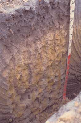 Humose–Acidic, Kandosolic, Redoxic HYDROSOL | |
| Simpson; north of Tomahawk Creek Road | |||
| Gently undulating plain | |||
| Neogene Hanson Plain Sand Formation | |||
| Gentle slope | |||
| 1% | |||
| South | |||
Horizon | Depth (cm) | Description | ||
A11 | 0–40/45 | Black (2.5Y2.5/1), grey (2.5Y6/1 dry) to light yellowish brown (2.5Y6/4 dry); light fine sandy loam; weakly pedal, very weak consistence; moderate amount of roots present; pH 5.1; clear boundary to: | ||
A12 | 45–55/60 | Greyish brown (2.5Y5/2 moist and dry); loamy sand; apedal; firm consistence; diffuse boundary to: | ||
B21g | 55/60–120 | Yellowish brown (10YR5/8) and light yellowish brown (2.5Y6/3) mottled; clayey sand; apedal; firm consistence; pH 4.8; gradual boundary to: | ||
B22g | 120 + | Light brownish grey (10YR6/2) with very coarse prominent yellowish brown (10YR5/6 and 5/8) mottles; clayey sand; apedal. | ||
| Management considerations | ||||
| Acidity of the profile and waterlogging are the major limitations. The high organic carbon content of the topsoil (7.7%) and overall topsoil depth are compensating factors. | ||||
Analytical data
Site SW64 | Sample depth | pH | EC | NaCl | Ex Ca | Ex Mg | Ex K | Ex Na | Ex Al | Ex acidity | FC (-10kPa) | PWP (-150kPa) | KS | FS | Z | C | |
Horizon | cm | H2O | CaCl2 | dS/m | % | cmolc/kg | cmolc/kg | cmolc/kg | cmolc/kg | mg/kg | cmolc/kg | % | % | % | % | % | % |
| A1 | 0–40 | 5.1 | 4.5 | 0.26 | N/R | 2.3 | 0.5 | 0.5 | 0.3 | 17 | 16 | N/R | N/R | 37 | 38.4 | 10 | 4.5 |
| B21g | 55–120 | 4.8 | 4.2 | 0.06 | N/R | 0.09 | 0.54 | <0.05 | 0.18 | 150 | 5.7 | N/R | N/R | 27.7 | 41.6 | 11.5 | 20.5 |
© State of Victoria (Agriculture Victoria) 1996 - 2025.

This work, Victorian Resources Online, is licensed under a Creative Commons Attribution 4.0 licence. You are free to re-use the work under that licence, on the condition that you credit the State of Victoria (Agriculture Victoria) as author, indicate if changes were made and comply with the other licence terms.
The licence does not apply to ‘branding’ or some ‘images or photographs’ that may be owned by third parties. We ask you to seek prior approval to use images using the VRO feedback form. Access to higher quality images can also be provided on request.
This page was last updated on 23/03/2020.