
3.1 Tomahawk Creek Tributary
|
This information has been developed from the publications:
|
| Location: | 3-092363. Seven kilometres north of Carlisle River. | |
Access: | Pipe Line Road. | |
Ownership: | Crown land. | |
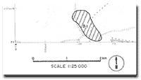
Geology /Geomorphology: | This site consists of a broad swampy depression which is linked by two outlets to a stream draining into Tomahawk Creek. Two small residual lakes occupy part of the depression. The basin is formed in deeply leached wind blown sands of the Dilwyn Formation. | |
Significance: | Regional. This is a clear example of the complex processes that produce the drainage pattern of the upper Tomahawk Creek. These include deflation, fluvial erosion and swamp development in areas where drainage is impeded. The small lakes are of particular interest. | |
© State of Victoria (Agriculture Victoria) 1996 - 2025.

This work, Victorian Resources Online, is licensed under a Creative Commons Attribution 4.0 licence. You are free to re-use the work under that licence, on the condition that you credit the State of Victoria (Agriculture Victoria) as author, indicate if changes were made and comply with the other licence terms.
The licence does not apply to ‘branding’ or some ‘images or photographs’ that may be owned by third parties. We ask you to seek prior approval to use images using the VRO feedback form. Access to higher quality images can also be provided on request.
This page was last updated on 23/03/2020.