
23.9 Lake Hordern and Aire Floodplain
|
This information has been developed from the publications:
|
The confluence of the Aire, Calder and Ford rivers provide the largest alluvial basin in the Otway shire. The basin is in part structural occupying the downthrown side of the Castle Cove Fault (Singleton, 1967), and in part erosional, having been enlarged by fluvial processes during Pleistocene glacial low sea level episodes. During interglacial higher sea level periods, the basin was flooded by the sea and the previously defined margins were extended by marine erosion. The basin is underlain by Otway Group sediments which now outcrop around the northern and eastern edges forming the distinctive ridge and valley terrain of the southern Otway Ranges.
As with the Johanna area, the Aire basin illustrates a Tertiary depositional sequence that differs from the major part of the Otway basin to the west. Attempts have been made therefore to establish a local scheme of rock nomenclature (reviewed in Douglas and Ferguson, 1976) and further detailed work is being undertaken (e.g. Marshallsea, 1982; Tingate, 1982).
Although the best outcrops of Tertiary strata are found in sites adjacent to the Aire (e.g. Castle Cove), several important stratigraphical sections occur on the coast near the Aire mouth and in cliffs fringing the floodplain.
Quaternary sediments in the Aire basin are complex and include shallow marine, estuarine, lagoonal and tidal sands, muds and shells, floodplain and lacustrine deposits and windblown sand. These record the changing environments (tectonic, climatic, marine) over the Pleistocene and Holocene and provide a major opportunity for studies in palaeoecology, geomorphology and prehistory.
The geomorphology of the Aire basin is dominated by three major units:
(a) the sequence of Pleistocene and Holocene calcareous sands that comprise the massive dune ridge that enclosed the basin - the Aire has cut a gorge across this at a time of lower sea level and this gorge is now being filled by aeolian sands;
(b) the Castle Cove Fault which delineates the north western edge of the basin;
(c) the present floodplain of the rivers representing a largely infilled estuary with residual wetlands and lakes.
| Location: | 23-142053. Three kilometres east of Glenaire. | 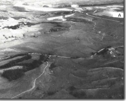 Aire River floodplain. Lake Hordern (A), Lake Costin (B), Fishing Point (C). |
Access: | From Great Ocean Road. | |
Ownership: | Private land. | |
Geomorphology: | The basin between Hordern Vale and Glenaire is the infilled former estuary of the lower Aire Valley. During the initial phase of present sea level (6 000 to 3 000 years ago), this basin was flooded as the sea entered the wide, deep gorge cut into Pleistocene calcarenite that now flanks the Aire River mouth. The basin filled as marine sand and shells accumulated, swept in by tides and waves. The entrance became constricted due to the growth of sand barriers and spits, and river sediments and brackish and freshwater swamp plant remains further built up the basin surface. The Aire River crosses this alluvial plain flanked by narrow and low level banks. Lakes Costin, Craven, etc occupy depressions on this surface where flood drainage back to the river is defeated by the level banks. The Aire has gentle, open meanders with no cutoffs or conspicuous crevasse splays. | |
Significance: | State. The flood basin has been severely disturbed by grazing and drainage and Lake Hordern represents the last area with remnant swamp vegetation. The site has been investigated by deep coring (11+ metres) and the sediments analysed for faunal and pollen remains (Head and Stuart, 1980), in an attempt to determine the palaeoecology of this and adjacent areas. Studies are restricted to areas such as Lake Hordern where the upper sedimentary sequence has not been compacted or drained. The absence of flood crevasse splays suggests the river has not been subject to very large floods since the development of the floodplain. An interesting comparison may be made here with the valley of the Snowy River below Orbost, which has extensive flood crevasse splays. | |
References: | Wilkinson, C.S. (1865). "Report on the Cape Otway country." (From Parl. Papers 1864-65). Rep. geol. Surv. Vict. Hall, T.S. & Pritchard, G.B. (1899). "The Tertiary deposits of the Aire and Cape Otway." Proc. R. Soc. Vict. 12: pp. 36-59. Chapman, F. (1904). "On some Cainozoic Foraminifera from Browns Creek, Otway Coast." Rec. geol. Surv. Vict. 1: pp. 227.230. Deane, H. (1904). "Prelininary report on fossil flora." Rec. Geol. Surv. Vict. 1: 13-14. Carter, A.N. (1958). "Tertiary Foraminifera from the Aire district Victoria." Bull. Geol. Surv. Vict. 55. Douglas, J.G. & Ferguson, J. (1976). "Geology of Victoria." Geol. Soc. Aust. Spec. Pub. 5: 528 pp. Singleton, O.P. (1976). "Otway Region. Excursions Handbook." 39th Congr. Aust. N.Z. Assoc. Advmt. Sci. Sect. C. pp. 171-181. Head, L. & Stuart, I. (1980). "Change in the Aire - palaeoecology and prehistory in the Aire basin, southwestern Victoria." Monash Pub. in Geog. 24: pp 102. Marshallsea, S.J. (1982). "The geology of the Johanna River area." B. Sc. Hons. Report (unpub.) Univ. of Melb. Tingate, P. (1982). "The geology of the Aire district." B. Sc. Hons. Report (unpub.) Univ. of Melb. | |
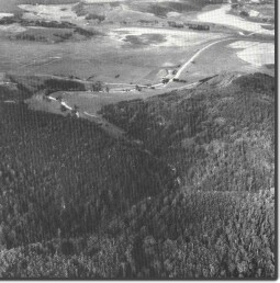 Aire River at Hordern Vale. River debouches from gorge onto short floodplain. |
© State of Victoria (Agriculture Victoria) 1996 - 2025.

This work, Victorian Resources Online, is licensed under a Creative Commons Attribution 4.0 licence. You are free to re-use the work under that licence, on the condition that you credit the State of Victoria (Agriculture Victoria) as author, indicate if changes were made and comply with the other licence terms.
The licence does not apply to ‘branding’ or some ‘images or photographs’ that may be owned by third parties. We ask you to seek prior approval to use images using the VRO feedback form. Access to higher quality images can also be provided on request.
This page was last updated on 23/03/2020.