
19.4 Kennett River - Lower
This information has been developed from the publications:
|
| Location: | 19-472162. Two kilometres west of Kennett River township. | |
Access: | Grey River Road. | |
Ownership: | Crown land (Reserved Forest and River Reserve). | |
Geology/Geomorphology: | Otway Group sandstones are exposed in the stream bed on the steeper bank of two incised meanders. | |
Significance: | Local. The entrenched meanders and outcrops are clear examples of the processes of dissection of the eastern Otway Ranges. | |
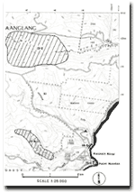 Site 19.2, 19.4 and 19.6 |
© State of Victoria (Agriculture Victoria) 1996 - 2025.

This work, Victorian Resources Online, is licensed under a Creative Commons Attribution 4.0 licence. You are free to re-use the work under that licence, on the condition that you credit the State of Victoria (Agriculture Victoria) as author, indicate if changes were made and comply with the other licence terms.
The licence does not apply to ‘branding’ or some ‘images or photographs’ that may be owned by third parties. We ask you to seek prior approval to use images using the VRO feedback form. Access to higher quality images can also be provided on request.
This page was last updated on 23/03/2020.