
2.1 Tomahawk Creek
|
This information has been developed from the publications:
|
| Location: | 2-045394. Eleven kilometres east of Simpson. | |
Access: | Coradjil Road. | |
Ownership: | Crown land. | |
Geology/Geomorphology: | Tomahawk Creek is incised into the Gellibrand Marl and the formation is poorly exposed in a section of the creek bank. At this site, there is a short swampy sector along the valley extending into the mouth of a small tributary creek. | |
Significance: | Local. This is typical of the Tomahawk Creek drainage system. | |
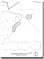 Tomahawk Creek Site 2.1 |
© State of Victoria (Agriculture Victoria) 1996 - 2025.

This work, Victorian Resources Online, is licensed under a Creative Commons Attribution 4.0 licence. You are free to re-use the work under that licence, on the condition that you credit the State of Victoria (Agriculture Victoria) as author, indicate if changes were made and comply with the other licence terms.
The licence does not apply to ‘branding’ or some ‘images or photographs’ that may be owned by third parties. We ask you to seek prior approval to use images using the VRO feedback form. Access to higher quality images can also be provided on request.
This page was last updated on 23/03/2020.