19.10 Cape Patton
This information has been developed from the publications:
|
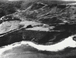
Location: Access: Ownership: | 19-465134. Five kilometres south-west of Kennett River. Great Ocean Road. Crown Land. | /$File/cp_cliffs(cave).jpg) Cape Patton cliffs and coastal terraces (A). The arrow indicates the position of Ramsdens Cave |
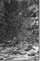
Geology/Geomorphology:  Photograph from Hardy (1910) of Ramsdens Cave at Cape Patton. The large X on the original plate is said to indicate the entrance although it is probably lower and to the left. | This site includes the highest cliffs in the eastern part of the Otway Shire. They occur along an east-west sector of coast to the west of Cape Patton, where the strike of the Mesozoic sandstones is parallel to the coast and the dip is landward. The Cape lies on the southern limb of the synclinal structure (Patton Syncline) with the dips clearly visible in the shore platform, cliffs and road cuttings. The rocks are strongly and closely jointed. One set of joint planes strikes north-north-east and a second west-north-west and both dip steeply (70o). Boulder scree slopes are extensive although much of the material is rubble produced by cuttings made for the Great Ocean Road. Of particular interest is Ramsdens Cave which lies just to the west of the lookout point on the Great Ocean Road. The cave has developed along joint plains in the Mesozoic sediments and consists of two chambers joined by a narrow passage. The chambers total 60 metres in length. The entrance is concealed and almost blocked by fallen rock from the overlying slope and cliff. The cave floor is approximately 12 metres above sea level and is mainly concealed by large pools of water. Analysis of the water by Hardy (1910) showed the presence of diatom frustules but the source of these is uncertain. Hardy also reported some decorations (stalactites and stalagmites) at the northern end of the second chamber and the presence of crystals of selenite (a variety of gypsum) on the roof and walls. In recent years, dinosaur bone fragments have been recovered from the shore platform at two localities east and west of Cape Patton within the boundary of this site. A more detailed search is likely to recover more abundant and significant material. | |
Significance: | National. The Cape Patton Cliffs are some of the highest on the Victorian coast. They have developed on a zone of landward dip in the Mesozoic rocks - one of the few places on the Otway coast where dips occur in that direction. The relationship between rock structure (bedding, dip, jointing) and variation in cliff and platform morphology is well displayed by the varied nature of the coastal profile. The low coastal terrace at Cape Patton is unusual for its proximity to the high cliffs to the west. The shape and form of this terrace assists in the analysis of the rate of evolution of the Otways coast. The dinosaur bone sites may yield material of international significance. Ramsdens Cave is one of the largest coastal caves in Victoria and one of the few large caves known in the Mesozoic sedimentary rocks. Its mode of origin and relationship to former sea levels has not been investigated in detail in recent times. |  Low cliffs and landslips west of Cape Patton |
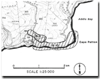
References: | Hardy, A. D. (1910). " Notes on Ramsdens Cave, Cape Patton" Vic. Nat. XIV:4-8. Melhuish, C. A. and Deane, C. (1937). "Victorian cave pools". Vic. Nat. |  Sites 19.9 and 19.10 |


