12.3 Boggaley Creek Boulder Beach
This information has been developed from the publications:
|
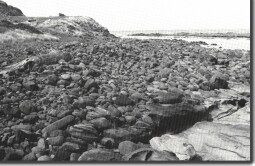
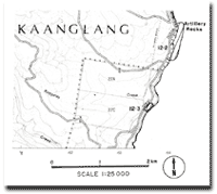
| Location: | 12-536217. Mouth of Boggaley Creek, three kilometres north of Wye River. |  Boulder beach at Boggaley Creek. |
Access: | Great Ocean Road. | |
Ownership: | Crown land. | |
Geomorphology: | A deposit of rounded boulders and gravels at the rear of the shore platform has been interpreted as an abandoned (and possibly emerged) boulder beach (Gill 1973). The boulders rest on an abraded rock surface that is a former short platform. Near the roadway the boulders are partly covered by soil and vegetation and are not now affected by wave action. They therefore were emplaced by waves that reached further inland than at present and their appearance suggests that this emplacement took place during the Holocene period. | |
Significance: | State. This is an important reference site for the study of stranded beach gravels with a view to determining Holocene sea level and storm wave conditions. No single accepted analysis of these conditions on the Otway coast has yet been advanced. | |
References: | Gill, E. D. (1973). "Rate and mode of retrogradation on rocky coasts in Victoria, Australia." Boreas 2: 143-171. | |


