WCSS07
Location: Bellarine
Australian Soil Classification: Vertic, Hypercalcic, Brown CHROMOSOL
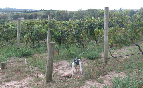
General Landscape Description: Low hills.
Site Description: Upper slope of a hill slope.
Geology: Neogene sediments, calcareous.
Land Use: Vineyard.

WCSS07 Landscape
Soil Profile Morphology:
Surface Soil
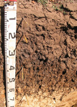
| A11 | 0-10 cm | Black (7.5YR2.5/1); firm surface condition; heavy sandy loam; weak medium platy structure; rough faced peds; firm consistence dry; contains a few medium ferruginous concretions; pH 6.5; clear change: |  WCSS07 Profile WCSS07 Profile |
| A12 | 10-20 cm | Very dark grey (7.5YR3/1); sandy loam; massive; earthy fabric; firm consistence dry; pH 6.4; abrupt change: | |
| Subsoil | |||
| B21 | 20-40 cm | Very dark grey (7.5YR3/1) with a few medium faint dark yellowish brown (10YR4/6) mottles; light medium clay; massive; strong very coarse angular blocky, parting to medium angular blocky structure, with some lenticular structure; very strong consistence dry; small slickenslides evident; pH 6.8; diffuse change: | |
| B22 | 40-70 cm | Yellowish brown (10YR5/4) with many distinct coarse very dark grey (7.5YR3/1) and reddish brown (5YR4/4) mottles; light medium clay; strong very coarse angular blocky, parting to medium angular blocky structure; strong consistence dry; pH 8.3; abrupt change: | |
| Ck | 70–130+ cm | Light brown (10YR6/3); medium clay; massive; strong consistence dry; abundant calcareous segregations; pH 9.4. |
Soil Profile Characteristics:
pH | Salinity Rating | ||
Surface (A1 horizon) | Slightly Acid | Low | None1 |
Subsoil (B21 horizon) | Slightly Acid | Low | Moderate2 |
Deeper Subsoil (at 70-130 cm) | Very Strongly Alkaline | Low to Medium | - |

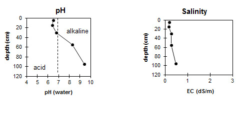
| The surface and upper subsoil is slightly acid. The deeper subsoil is very strongly alkaline. | The salinity rating in the surface and upper subsoil is low. The deeper subsoil has a low to medium salinity rating. |
Horizon | Horizon Depth (cm) | pH (water) | pH (CaCl2) | EC dS/m | Coarse Sand (0.2-2.0 mm) | Fine Sand (0.02-0.2 mm) | Silt (0.002-0.02 mm) | Clay (<0.002 mm) |
A11 | 0-10 | 6.5 | 6.1 | 0.19 | ||||
A12 | 10-20 | 6.4 | 5.9 | 0.15 | ||||
B21 | 20-40 | 6.8 | 6.0 | 0.26 | 7 | 20 | 4 | 64 |
B22 | 40-70 | 8.3 | 7.4 | 0.26 | ||||
Ck | 70-130+ | 9.4 | 8.5 | 0.47 |
Profile Described By: David Rees and Siegfried Engleitner (March 2010).


