SW13
Location: Lake Corangamite
Australian Soil Classification: Endocalcareous, Self-Mulching, Black VERTOSOL
General Landscape Description: Lunette.
Site Description: Upper mid slope. Weak gilgai evident.
Landuse: Pasture grazing – sheep and beef.
Geology: Quaternary aeolian deposits derived from lake bed sediments.

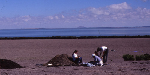
SW13 Landscape – view downslope from SW14 towards the lower slope and terrace of the lunette.
Soil Profile Morphology:
Surface Soil
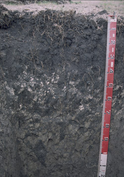
| A11 | 0-4 cm | Black (N2.5/0); surface self mulching and cracking; silty clay; very fine polyhedral structure; pH 7.8; clear and smooth change to: |  |
| A12 | 4-15 cm | Black (N2.5/0); silty clay; coarse polyhedral, parting to fine polyhedral structure; very firm consistence dry; contains an abundant amount of fine sized roots; pH 8.1; clear and smooth change to: | |
| Subsoil | |||
| B21kt | 15-30 cm | Black (N2.5/0); light medium clay; coarse prismatic, parting to coarse angular blocky, parting to very fine polyhedral structure; contains very few (<5%) carbonate segregations; faint slickensides evident; slightly calcareous; pH 8.5; gradual and smooth change to: | |
| B22kt | 30-60 cm | Dark grey (N4/0); medium clay; coarse prismatic, parting to coarse angular blocky, parting to very fine polyhedral structure; strong consistence dry; contains a common (10-20%) amount of soft, pinkish grey coloured (5YR7/2) carbonate segregations; very fine slickensides evident; pH 9.2; gradual and wavy change to: | |
| B3 | 60-100 cm | Olive grey (5YR5/2); light clay; coarse prismatic parting to polyhedral structure; contains shell fragments; contains fine (2 mm in diameter) roots; very fine pores present; pH 9.6. | |

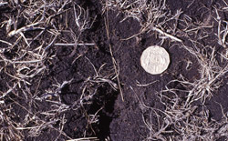
Cracking and self-mulching surface condition.
Soil Profile Characteristics:
pH | Salinity Rating | |||
Surface (A1 horizon) | Slightly Alkaline | Low to Medium | Non Sodic | None |
Subsoil (B21 horizon) | Moderately Alkaline | Low to Medium | Sodic | None |
Deeper Subsoil (at 60-100 cm) | Extremely Alkaline | Very High | Strongly Sodic | None1 |

|
|
|
|
Horizon | Horizon Depth (cm) | pH (water) | pH (CaCl2) | EC ds/m | NaCl % | Exchangeable Cations | |||
Ca | Mg | K | Na | ||||||
meq/100g | |||||||||
A11 | 0-4 | 7.8 | 7.4 | 0.27 | <0.05 | 27 | 35 | 3.1 | 0.85 |
A12 | 4-15 | 8.1 | 7.6 | 0.21 | 29 | 37 | 2.1 | 0.98 | |
B21kt | 15-30 | 8.5 | 7.9 | 0.22 | 34 | 47 | 1.5 | 1.5 | |
B22 | 30-60 | 9.2 | 8.5 | 0.38 | <0.05 | 3.5 | 32 | 1.7 | 4.3 |
B3kt | 60-100 | 9.6 | 8.5 | 0.71 | <0.05 | 0.8 | 28 | 2.2 | 11 |
Horizon | Horizon Depth (cm) | Total Nitrogen g/100g | Organic Carbon % | Wilting Point pF4.2 | Coarse Sand (0.2- 2.0 mm) | Fine Sand (0.02- 0.2 mm) | Silt (0.002- 0.02 mm) | Clay (<0.002 mm) |
A11 | 0-4 | 0.39 | 4.7 | 40 | 2 | 20 | 35 | 25 |
A12 | 4-15 | 39 | 0 | 12 | 29 | 39 | ||
B21 | 15-30 | 41 | 0 | 25 | 30 | 22 | ||
B22 | 30-60 | 35 | 0 | 25 | 23 | 17 | ||
B3 | 60-100 | 0 | 26 | 25 | 18 |
Profile Described By: Richard MacEwan, John Martin, Mark Imhof (March 1997).


