SW12
Location: Lake Corangamite
Australian Soil Classification: Epicalcareous-Endohypersodic, Self-Mulching, Black VERTOSOL
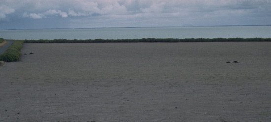
General Landscape Description: Lunette.
Site Description: Virtual upper crest.
Land Use: Pasture grazing – sheep and beef.
Geology: Quaternary aeolian deposits derived from lake bed sediments.

SW12 Landscape - general view of Lake Corangamite showing lower slope and terrace of the lunette.
Soil Profile Morphology:
Surface Soil
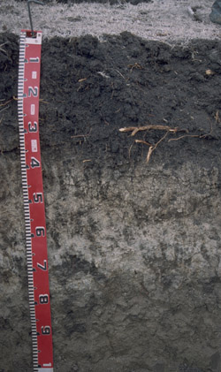
| A11 | 0-2 cm | Black (N2.5/0); loose, self-mulching surface condition; silty clay; fine polyhedral structure; moderately calcareous; pH 7.3; changing to: |  SW12 Profile SW12 Profile |
| A12 | 2-20 cm | Black (N2.5/0); light clay; coarse sub-angular blocky, parting to very fine polyhedral structure; rough faced peds; firm consistence dry; slight carbonate present; moderately calcareous; pH 7.6; changing to: | |
| Subsoil | |||
| B21kt | 18-30 cm | Black (N2.5/0) with many (30%) olive brown (2.5Y4/3) mottles; light medium clay; fine prismatic structure parting to fine polyhedral structure; rough faces on prismatic structure, and some shiny surfaces on polyhedral structure; fine pores (1.5 per cm2) present; very firm consistence dry; contains coarse roots that stop at boundary; carbonate present; very highly calcareous; pH 8.4; changing to: | |
| B22k | 30-52 cm | Light yellowish brown (2.5Y6/3) with olive brown (N4/0) infill; light clay; coarse prismatic, parting to medium platy and polyhedral structure; contains an abundant amount of visible carbonate; firm consistence dry; very fine (>5 per cm2) pores; very highly calcareous; pH 9.1; changing to: | |
| B23k | 52-75 cm | Light olive brown (2.5Y5/3) with dark grey (N4/0) infill; light clay; coarse prismatic, parting to medium platy and polyhedral structure; firm consistence dry; fine (1-5 per cm2) pores; very highly calcareous; pH 9.5; changing to: | |
| B3 | 75-120 cm | Olive grey (5Y4/2); light clay; coarse prismatic parting to fine polyhedral structure; friable consistence moist, very firm consistence dry; contains small sized shell fragements and a medium amount of quartz fragments; small slickensides evident; very highly calcareous; pH 9.6. | |
Soil Profile Characteristics:
pH | Salinity Rating | |||
Surface (A11 horizon) | Slightly Alkaline | Low | Non Sodic | None1 |
Subsoil (B21 horizon) | Moderately Alkaline | Low | Non Sodic | None |
Deeper Subsoil (at 75-120 cm) | Extremely Alkaline | Medium | Strongly Sodic | None2 |

| The surface horizon is slightly alkaline. The subsoil is moderately alkaline, becoming extremely alkaline with depth. |
|
|
|
Horizon | Horizon Depth (cm) | pH (water) | pH (CaCl2) | EC ds/m | NaCl % | Exchangeable Cations | |||
Ca | Mg | K | Na | ||||||
meq/100g | |||||||||
A11 | 0-2 | 7.3 | 6.8 | 0.21 | 16 | 25 | 3.5 | 0.81 | |
A12 | 2-20 | 7.6 | 7.1 | 0.23 | 15 | 26 | 2.7 | 1.4 | |
B21 | 20-30 | 8.4 | 8 | 0.33 | 0.05 | 12 | 23 | 1.4 | 1.2 |
B22 | 30-50 | 9.1 | 8.4 | 0.27 | <0.05 | 15 | 30 | 1.4 | 1.8 |
B23 | 50-75 | 9.5 | 8.7 | 0.48 | <0.05 | 1.2 | 21 | 1.7 | 4.6 |
B3 | 75-120 | 9.6 | 8.7 | 0.58 | <0.05 | 1.2 | 19 | 2.1 | 6.4 |
Horizon | Horizon Depth (cm) | Total Nitrogen g/100g | Organic Carbon % | Wilting Point pF4.2 | Coarse Sand (0.2- 2.0 mm) | Fine Sand (0.02- 0.2 mm) | Silt (0.002- 0.02 mm) | Clay (<0.002 mm) |
A11 | 0-2 | 0.32 | 3.4 | 30 | 12 | 9 | 12 | 53 |
A12 | 2-20 | 32 | 12 | 9 | 10 | 58 | ||
B21 | 20-30 | 29 | 14 | 10 | 11 | 49 | ||
B22 | 30-50 | 23 | 15 | 11 | 5 | 47 | ||
B23 | 50-75 | 26 | 11 | 9 | 4 | 49 | ||
B3 | 75-120 | 27 | 8 | 8 | 16 | 42 |
Profile Described By: Richard MacEwan, John Martin, Mark Imhof (March 1997).


