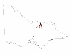
1.4.6 Outlying ridges and hills (Warby Range, Lurg Hills, Howe Range, Mt Dandenong)
1. Eastern Uplands (EU)
1.4 Dissected landscapes at a range of elevations
| Low hills and low outlying ridges are usually continuations of the dividing ridges of the main drainage systems. The Warby Range is the northern end of the divide between the Ovens River and the Broken River catchments. Further to the west, the Lurg hills mark the divide between Ryans Creek (a tributary of the Broken River) and Fifteen Mile Creek (a tributary of the Ovens River). The knot of low ridges and hills of the Leneva hills form the divide between Indigo Creek, (a small tributary of the Murray River) and the Kiewa River. Local relief is usually no more than about 200 m and slopes are moderate with rounded crests and concave lower slopes grading via alluvial/colluvial fans into valleys, often with ephemeral streams, or merging into the margins of Tier 1.3.3 or either the Northern Riverine Plains (Tier 4) or the Eastern Plains (Tier 7). Mt Dandenong (618 m) in Devonian dacites and the Cathedral Range (c. 1000 m) near Buxton, composed of hard Devonian sandstone, are outlying eminences rising sharply above their surroundings. |  |
The native vegetation has been cleared from most of these landscapes. The original vegetation in the drier areas was probably woodland to low open forest of Red Stringybark, Broad-leaf Peppermint, Red Box and Long-leaf Box with a sparse ground-cover of low shrubs and grasses. Tall open forest of Narrow-leaf Peppermint, Mountain Grey Gum, and Messmate Stringybark occur in areas of higher rainfall.
On the more stable, lower valley-side slopes, soils are mostly red and brown acid texture contrast soils (Kurosols) tending to red and brown gradational soils (Dermosols) in higher rainfall areas. On drier and less-stable slopes poorly structured texture contrast soils (Kandosols) and stony soils with little pedogenic development (Leptic Rudosols and Tenosols) are more common.


