
Montgomery (Mt)
|
Geology | 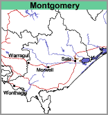 | 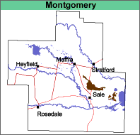 |
Prior to the incision of the modern stream system, earlier stream systems (called prior streams) deposited alluvium that now makes up the Tinamba, Denison and Montgomery map units. The Montgomery map unit occurs on what was then the far flood plain of these earlier stream systems. The surface soils are deeper and the overall profile less clayey than the soils of the Denison map unit, and the Tinamba map unit (redder soil) occurs closer to the prior streams.
Original Vegetation
It is likely that this map unit was predominantly covered by grassland (Lunt, 1997). Although Skene and Walbran referred to this area as a sparsely timbered plain, aerial photography in 1935 showed no evidence of native trees.
Previous Maps and Reports
The soil types within the Montgomery map unit were named by Skene and Walbran (1949) and Poutsma (1956). The Montgomery map unit mainly comprises the following soil types from these previous reports: Montgomery clay loam, Bundalaguah clay loam, with some Denison clay loam, light phase. Minor areas of other soil types also occur. Bundalaguah clay loam has browner subsoil than Montgomery clay loam and is slightly less clayey in the deep subsoil.
Ward (1977) included all of the prior stream related mapping units described on this web site (i.e. Tinamba, Montgomery, Denison and Wandocka) into the Bundalaguah soil association. The present Montgomery mapping unit was included within the broader Sale Land System as described by Aldrick et al. (1992).
Soils
The surface soils are generally deep (up to 45 cm) and are dark greyish brown to dark brownish grey fine sandy clay loams. They may have a sporadically bleached sub-surface of similarly textured material. There is a sharp change at about 40 cm to mottled light to medium clay with yellow and brown colours predominating. Before one metre depth, the soil generally becomes a mottled grey, yellow and brown silty light or medium clay. The soils in this unit are generally classified as Brown Sodosols using the Australian Soil Classification.
Chemical and Physical Analysis
Soil Pit Site GP70 is located on this map unit and is described below. Skene and Walbran (1949) described two other sites below. The pH of the surface soil is about 5.5 and the subsoils become strongly alkaline and increasingly sodic with depth.
GP70. Soil Pit Site (Sargeant and Imhof, 2000)
Depth cm | Texture | pH | EC dS/m | Cl % | Nitrogen % | Carbon % | Ca meq% | Mg meq% | K meq% | Na meq% | H meq% | ESP % | Gravel % | Coarse sand % | Fine sand % | Silt % | Clay % | LAT % |
0-10 | FSCL | 5.4 | 0.45 | 0.05 | 0.39 | 4.0 | 6.8 | 2.5 | 0.3 | 0.5 | 5 | 30 | 34 | 22 | 2 | |||
10-20 | FSCL | 5.1 | 0.26 | 0.04 | 0.14 | 1.9 | 5.0 | 1.8 | 0.2 | 0.3 | 11.0 | 5 | 3 | 34 | 34 | 25 | 1 | |
30-40 | FSCL | 5.9 | 0.19 | 2.9 | 3.0 | 0.2 | 1.3 | 4.2 | 12 | 4 | 36 | 33 | 26 | <1 | ||||
40-80 | LMC | 6.9 | 0.35 | 0.04 | 3.6 | 6.6 | 0.2 | 1.2 | 11 | 1 | 29 | 27 | 43 | 1 | ||||
80-120 | LMC | 8.8 | 0.36 | 0.04 | 2.3 | 7.0 | 0.2 | 3.4 | 27 | 2 | 23 | 37 | 40 | <1 | ||||
120+ | LC | 9.3 | 0.32 | 0.05 | 1.7 | 5.4 | <0.1 | 3.1 | 30 |
Bundalaguah clay loam, (Skene and Walbran 1949)
Depth cm | Texture | pH | EC dS/m | Cl % | Nitrogen % | Carbon % | Ca meq% | Mg meq% | K meq% | Na meq% | H meq% | ESP % | Gravel % | Coarse sand % | Fine sand % | Silt % | Clay % | LAT % |
0-20 | CL | 5.8 | 0.07 | .006 | 0.235 | 3.20 | 12 | 29 | 29 | 21 | 1 | |||||||
20-38 | CL | 6.0 | 0.06 | .013 | 11 | 32 | 31 | 22 | 1 | |||||||||
40-66 | MC | 7.3 | 0.17 | .024 | 3 | 22 | 31 | 38 | 1 | |||||||||
66-86 | FSC | 8.8 | 0.32 | .045 | 1 | 32 | 31 | 32 | 1 | |||||||||
86-117 | FSC | 9.4 | 0.45 | .056 | 4 | 1 | 46 | 25 | 26 | 1 | ||||||||
117-145 | FSCL | 9.0 | 0.34 | .054 | <1 | 64 | 19 | 16 | 1 |
Denison clay loam, light phase, (Skene and Walbran 1949)
Depth cm | Texture | pH | EC dS/m | Cl % | Nitrogen % | Carbon % | Ca meq% | Mg meq% | K meq% | Na meq% | H meq% | ESP % | Gravel % | Coarse sand % | Fine sand % | Silt % | Clay % | LAT % |
0-13 | FSCL | 5.6 | 0.23 | .022 | 0.160 | 2.13 | 12 | 35 | 33 | 15 | 1 | |||||||
13-25 | CL | 5.4 | 0.27 | .046 | 10 | 37 | 33 | 17 | 1 | |||||||||
25-36 | CL | 5.6 | 0.33 | .058 | 8 | 36 | 33 | 19 | 1 | |||||||||
36-46 | MC | 5.9 | 0.70 | .121 | 4 | 25 | 28 | 39 | 2 | |||||||||
46-71 | MC | 7.1 | 0.92 | .155 | 2 | 2 | 20 | 28 | 44 | 1 | ||||||||
71-86 | LC | 8.1 | 0.85 | .137 | 1 | 27 | 29 | 38 | 2 | |||||||||
86-127 | FSC | 8.3 | 0.77 | .125 | 1 | 29 | 36 | 30 | 1 | |||||||||
127-175 | LC | 9.0 | 0.75 | .120 | <1 | 11 | 48 | 37 | 1 |
The following abbreviations are used to describe field texture: S - sand; LS - loamy sand; ClS - clayey sand; SL - sandy loam; L - loam; CL - clay loam; SCL - sandy clay loam; SC - sandy clay; FSCL - fine sandy clay loam; FSC - fine sandy clay; LC - light clay; MC - medium clay; HC - heavy clay; GR - gravel; ZL - silty loam; ZCL - silty clay loam; ZLC - silty light clay; ZMC - silty medium clay.
Particle size distribution data given for Skene and Walbran (1948, 1949) does not include the water content of the soil. As a result the coarse sand, fine sand, silt, clay and loss on acid treatment (LAT) may not add up to 100%.
Other symbols include: pH - analysed in water; EC - electrical conductivity; Cl - chloride; Ca - exchangeable calcium; Mg - exchangeable magnesium, K - exchangeable potassium; Na - exchangeable sodium; H - exchangeable hydrogen; ESP - exchangeable sodium percentage.
For Soil Pit Sites (Sargeant and Imhof, 2000) exchangeable cations have been determined using Gilman method (where pH >7) and Tucker method (pH <7). Exchangeable Sodium % (ESP) has been calculated here as the percentage of sodium in relation to the sum of the exchangeable basic cations.
Land Use
"Both Bundalaguah clay loam and Montgomery clay loam are quite suitable for irrigated pastures. Bundalaguah clay loam has been recommended for both permanent pastures and lucerne. Montgomery clay loam with its heavier and possibly less permeable subsoil may be somewhat inferior for the latter crop” (Poutsma, 1956).
© State of Victoria (Agriculture Victoria) 1996 - .

This work, Victorian Resources Online, is licensed under a Creative Commons Attribution 4.0 licence. You are free to re-use the work under that licence, on the condition that you credit the State of Victoria (Agriculture Victoria) as author, indicate if changes were made and comply with the other licence terms.
The licence does not apply to ‘branding’ or some ‘images or photographs’ that may be owned by third parties. We ask you to seek prior approval to use images using the VRO feedback form. Access to higher quality images can also be provided on request.
This page was last updated on .