
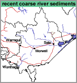
Recent Coarse River Sediments (rc)
|
| 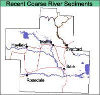 |
| Geology Recent (contemporary) channel deposits from the Avon River. Landform Meander plain. |
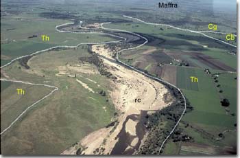 Recent Coarse River Sediments mapping unit beside the Avon River. |
Original Vegetation
The original vegetation has been described as riverine scrubs and swamps (Lunt, 1997).
Soils
The soils are comprised of undifferentiated sands, gravels and small cobbles.
Chemical and Physical Analysis
No pits have been dug in this map unit, however, one site was examined by Aldrick et al. (1992).
Profile 17, Stratford 1, Aldrick et al. (1992)
Depth cm | Texture | pH | EC dS/m | Cl % | Nitrogen % | Carbon % | Ca meq% | Mg meq% | K meq% | Na meq% | H meq% | ESP % | Gravel % | Coarse sand % | Fine sand % | Silt % | Clay % | LAT % |
1-10 | S | 6.0 | 0.04 | .003 | 0.046 | 0.54 | 0.8 | 0.8 | 0.5 | <0.1 | 1.0 | <1 | 62 | 34 | 2 | 2 | ||
20-30 | S | 5.8 | 0.03 | .001 | 0.047 | 0.047 | 1.6 | 0.8 | 0.4 | <0.1 | 4.7 | <1 | 2 | 22 | 66 | 6 | 5 | |
30-60 | S&GR | 5.8 | 0.01 | .001 | 0.7 | 0.4 | 0.1 | <0.1 | 0.9 | <1 | 1 | 81 | 17 | <1 | 3 | |||
90-120 | S | 6.5 | 0.01 | .001 | 1.0 | 1.0 | 0.1 | <0.1 | 1.2 | <1 | 51 | 44 | 4 | 2 |
The following abbreviations are used to describe field texture: S - sand; LS - loamy sand; ClS - clayey sand; SL - sandy loam; L - loam; CL - clay loam; SCL - sandy clay loam; SC - sandy clay; FSCL - fine sandy clay loam; FSC - fine sandy clay; LC - light clay; MC - medium clay; HC - heavy clay; GR - gravel; ZL - silty loam; ZCL - silty clay loam; ZLC - silty light clay; ZMC - silty medium clay.
Aldrick et al. (1992) does not provide LAT data.
Other symbols include: pH - analysed in water; EC - electrical conductivity; Cl - chloride; Ca - exchangeable calcium; Mg - exchangeable magnesium, K - exchangeable potassium; Na - exchangeable sodium; H - exchangeable hydrogen; ESP - exchangeable sodium percentage.
Land Use
As the area is frequently flooded, only grazing and gravel extraction is carried out on this land.
© State of Victoria (Agriculture Victoria) 1996 - .

This work, Victorian Resources Online, is licensed under a Creative Commons Attribution 4.0 licence. You are free to re-use the work under that licence, on the condition that you credit the State of Victoria (Agriculture Victoria) as author, indicate if changes were made and comply with the other licence terms.
The licence does not apply to ‘branding’ or some ‘images or photographs’ that may be owned by third parties. We ask you to seek prior approval to use images using the VRO feedback form. Access to higher quality images can also be provided on request.
This page was last updated on .