
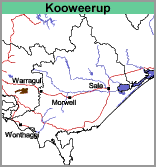
Koo Wee Rup (Kp)
 |
Geology
Recent lacustrine (lake or swamp) deposits.
Landform
Lacustrine plain.
Soils
Goudie (1942) defines three phases of this soil type: normal phase, burnt peat phase and the deep peat phase. He mapped two of these, the normal phase (which includes the burnt phase) and the deep peat phase. The normal phase has a peaty clay surface layer about 9 inches (230 mm) thick overlying a gritty clay. The deep peat phase has an additional peat layer up to 12 inches (300 mm) thick below the peaty clay surface.
During the course of this survey all of these phases were found but they could not be mapped separately. The depth of surface soil in the normal phase was found to be slightly deeper than that reported by Goudie and generally was between 250 and 400 mm deep. Only small scattered occurrences of the other two phases were found.
The main type, Koo Wee Rup peaty clay, has about 300 mm of dark greyish brown to dark brown loam or light clay surface soil with high amounts of peat or organic matter. This peat, which was originally deeper, accumulated in the marshes and lagoons fed by slow-moving water. Since drainage, much peat has disappeared through shrinkage, consolidation, burning and blowing.
Below the peat layer, dominantly dark grey medium or heavy clays occur, passing at about 500 mm to mottled paler grey and yellow-brown mottled medium to heavy. The clay continues to at least 1.8 m. Variable amounts of gritty sand to gravel may occur throughout the soil profile.
These soils can usually be referred to as Humose-Acidic, Eutrophic, Grey DERMOSOLS using the Australian Soil Classification. Soil site information is available for Soil Pit Sites GP26 and GP28.
Typical Profile of Koo Wee Rup Peaty Clay
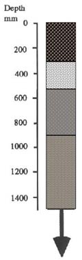 | 0 - 300 mm. Grey-brown to brownish grey peaty clay, clear transition to: 300 - 500 mm. Dark grey gritty clay*, diffuse transition to: 500 - 900 mm. Grey mottled with yellow-brown gritty clay*, diffuse transition to: 900 mm continuing to 1000 mm +. Grey or pale grey mottled with yellow-brown gritty clay*. *Grittiness varies considerably. |
The peaty clay soils are used for improved pastures and cropping, generally potatoes. Increasing areas are being planted to asparagus. Pastures and green manure crops such as oats, rye, corn and lupins are used to maintain organic matter levels between potato crops. There has been an increasing trend towards planting successive potato crops followed by a ley period of several years. Maintenance of organic matter is essential for the long-term agricultural viability of Koo Wee Rup peaty clay.
Koo Wee Rup peaty clay with sandy rises (Kp/sr)
Much of the area is mapped as Koo Wee Rup peaty clay with sandy rises.
These sandy rises are the remnants of the beds and levees of streams that flowed from the Eastern Highlands. The highlands immediately to the north are mainly comprised of weathering granodiorite which provided the source of the gravel, sand, silt and clay deposited within the swamp. When the swamp was drained and the streams confined to well defined drains, sediment deposition within the swamp, including the sands and gravels, ceased and now occurs within the drains and in Westernport Bay. Some gravel extraction from the drains is carried out.
Areas on the soil map inscribed with Ko/sr (i.e. "with sandy rises") indicate that more than 20% of the area is comprised of gravelly to sandy soils. The sand and gravel throughout the soil profile is quite angular. The sand fraction may contain variable proportions of fine sand, coarse sand or gravel. In general, coarse sand and gravel predominates in the north-east of this region and fine sand in the south-west. This is because the coarser fraction tended to be deposited closer to the sand source.
© State of Victoria (Agriculture Victoria) 1996 - .

This work, Victorian Resources Online, is licensed under a Creative Commons Attribution 4.0 licence. You are free to re-use the work under that licence, on the condition that you credit the State of Victoria (Agriculture Victoria) as author, indicate if changes were made and comply with the other licence terms.
The licence does not apply to ‘branding’ or some ‘images or photographs’ that may be owned by third parties. We ask you to seek prior approval to use images using the VRO feedback form. Access to higher quality images can also be provided on request.
This page was last updated on .