
Gurdies (Gd)
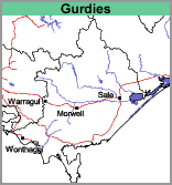 | This small unit occurs on the Western edge of the Warragul mapsheet. It is close to the coastline on the eastern side of Port Phillip Bay and lies within the Port Phillip and Westernport region. Soil Site GP56 is an example of a Brown Kurosol that occurs in the Gurdies mapping unit. |
© State of Victoria (Agriculture Victoria) 1996 - .

This work, Victorian Resources Online, is licensed under a Creative Commons Attribution 4.0 licence. You are free to re-use the work under that licence, on the condition that you credit the State of Victoria (Agriculture Victoria) as author, indicate if changes were made and comply with the other licence terms.
The licence does not apply to ‘branding’ or some ‘images or photographs’ that may be owned by third parties. We ask you to seek prior approval to use images using the VRO feedback form. Access to higher quality images can also be provided on request.
This page was last updated on .