
Victorian Dairy Soils - Kandosol
Back to: Victorian Dairy Soil
Distribution
| Kandosols lack strong texture contrast between the surface (A) horizons and subsoil (B) horizons. They are also characterised by having massive (structureless) or only very weakly structured subsoils and are often 'earthy' in appearance. Some part of the weakly developed B horizon must have a clay content of more than 15%. Kandosols are usually well drained, permeable soils and often have low fertility. | 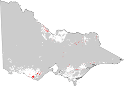 |
| Both Red and Brown Kandosols, and to a much lesser extent Yellow Kandosols, occur throughout the steep lower slopes and the alluvial/colluvial landscapes in North East Victoria. They are particularly common on steeper slopes associated with granitic and gneissic parent materials and in higher rainfall areas. The brown and yellow forms appear to be the more hydromorphic variations and generally occur in more poorer drained situations than the red forms. | 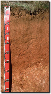 |
| In the northern alluvial plains, Red Kandosols can occur in prior stream landscapes, often associated with channel deposits. Soil Pit Site GN23 is an example of a Red Kandosol in East Shepparton. In South-West Victoria, Kandosols are not common. They mainly occur on some hills south of Colac and near Port Campbell and Anglesea, as well as on some more recent floodplains. Brown Kandosols (see Soil Pit Site SW24 as an example) occur around Simpson, associated with lateritised sand and clay deposits. | 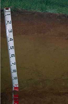 |
Management Considerations
Kandosols are generally well drained, permeable soils that are inherently low in fertility. In higher rainfall areas they are likely to be strongly acidic throughout much of the profile. A pH/aluminium test on a bulked sample taken from across the paddock would be most appropriate for determining how much lime is needed to raise soil pH.
© State of Victoria (Agriculture Victoria) 1996 - 2025.

This work, Victorian Resources Online, is licensed under a Creative Commons Attribution 4.0 licence. You are free to re-use the work under that licence, on the condition that you credit the State of Victoria (Agriculture Victoria) as author, indicate if changes were made and comply with the other licence terms.
The licence does not apply to ‘branding’ or some ‘images or photographs’ that may be owned by third parties. We ask you to seek prior approval to use images using the VRO feedback form. Access to higher quality images can also be provided on request.
This page was last updated on 23/03/2020.