
Sb2 Deverall Hill
|
This information has been developed from the publications:
|
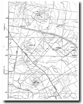
| Location | Sunbury - 912435. Shire of Bulla. North of Calder Highway 6 km southeast of Sunbury. | 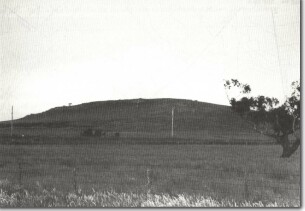 Sb2 - Deverall hill eruption point. |
Access | Calder Highway | |
Ownership | Private land | |
Site Description | Deverall Hill is a steep volcanic hill with a circular depression at the summit surrounded by outward-facing ridges of lava. On the western slopes are twin lava ridges resulting from the last lava eruption of the volcano. Earlier and broader lava flows extend from the base of the hill towards the west and north. The flattened, rocky and circular summit and long slope to the west result from erosion of scoriaceous material of the original cone exposing the central plug of the volcano and the sides of the final lava flow that breached the cone. A small disused quarry is on the lower southern slope of the hill. | |
Significance | State. The hiss is a classic example of the production of a flat-topped volcanic hill by erosion. It is an important example of a major volcanic form of the Newer Volcanics of Victoria. | |
Management | Class 2. No building or quarrying (apart from that necessary to service existing rural land uses) should be permitted above the 440 m contour. | |
References | Edwards, A.B. and Crawford, W. (1940). |

© State of Victoria (Agriculture Victoria) 1996 - .

This work, Victorian Resources Online, is licensed under a Creative Commons Attribution 4.0 licence. You are free to re-use the work under that licence, on the condition that you credit the State of Victoria (Agriculture Victoria) as author, indicate if changes were made and comply with the other licence terms.
The licence does not apply to ‘branding’ or some ‘images or photographs’ that may be owned by third parties. We ask you to seek prior approval to use images using the VRO feedback form. Access to higher quality images can also be provided on request.
This page was last updated on .