
K1 Bulla - Kaolinized Granodiorite
|
This information has been developed from the publications:
|
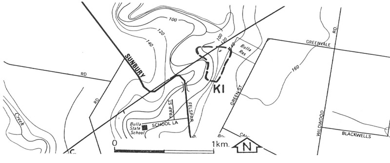
| Location | Keilor - 061327. Shire of Bulla. Eastern side of Deep Creek upstream of the Sunbury Road bridge. | 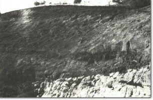 K1 - Newer Volcanics lava flows overlying weathered granite, Bulla. |
| Access | Track along river from Felspar Street. | |
| Ownership | Some Crown land, some private land | |
Site Description | Abandoned quarries into the steep hillslope east of Deep Creek expose Bulla Granodiorite beneath Newer Volcanics lava flows. The granite is generally deeply weathered and the felspars have decomposed to kaolinite - a grey-white aluminium rich clay which has a number of industrial uses. In places there are concentrations of remnant quartz in the kaolin. At the lower levels in the quarry, along the track above Deep Creek, less weathered strongly jointed granodiorite is intruded by a number of aplite dykes up to 25 cm wide. In the quarry at the end of the track, there is a clear section exposing the base of the lava flows overlying the kaolinite. | |
| Significance | State. The site is an outstanding example of deep weathering of granodiorite to produce an in situ deposit of kaolinite. It shows clearly the uneven nature of subsurface weathering as fresh sections of granodiorite lie adjacent to deeply weathered ones. It is therefore an important site to demonstrate stages in the origin of boulders (tors). It also clearly displays the unconformity between the lava flows and the weathered granodiorite. It is readily accessible and is used extensively by schools and tertiary institutions as a teaching site. | |
| Management | Class 2. The unused quarry sections should be retained as teaching sites. No reclamation or filling should be permitted and they should not be used as refuse pits. In the longer term, access to the site could be improved by providing a parking bay or widening the intersection near the bridge to increase the safety for vehicles entering or leaving the site. | |
| References | James, A.V.C. (1920). The Physiography and Geology of the Bulla/Sydenham Area. Proc. R. Soc. Vict. 32:323-349. Gaskin, A.J. (1944). Kaolinized Granodiorite in the Bulla/Broadmeadows area. Proc. R. Soc. Vict. 56:1-18. | |
 K1
K1

© State of Victoria (Agriculture Victoria) 1996 - .

This work, Victorian Resources Online, is licensed under a Creative Commons Attribution 4.0 licence. You are free to re-use the work under that licence, on the condition that you credit the State of Victoria (Agriculture Victoria) as author, indicate if changes were made and comply with the other licence terms.
The licence does not apply to ‘branding’ or some ‘images or photographs’ that may be owned by third parties. We ask you to seek prior approval to use images using the VRO feedback form. Access to higher quality images can also be provided on request.
This page was last updated on .