
Mount Blackwood
|
This information has been obtained from the report: Eruption Points of the Newer Volcanic Province of Victoria by Neville Rosengren. This report was published in 1994 and was prepared for the National Trust of Australia (Victoria) and the Geological Society of Australia (Victorian Division). The review of eruption points was based on an earlier unpublished manuscript Catalogue of the post-Miocene volcanoes of Victoria compiled by O P Singleton and E B Joyce (Geology Department, University of Melbourne 1970). |
| Clarkes Big Hill | 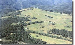 Mount Blackwood | |
37 32 60S 144 21 30E (external link); 7722-1-4 (Greendale) 667399. 14 km NW of Bacchus Marsh, Mount Blackwood Road. | ||
Bacchus Marsh. | ||
Private land: | Bare, grazing, communications tower on summit, weather outcrop. | |
Type 9: | Composite scoria cone overlying lava flows. | |
Mount Blackwood is a prominent scoria dome built on lava flows extending 8 km to the south. The flows are narrow and elongated and followed an upland valley thus covering stream gravels. Korkuperrimal Creek and Myrniong Creek have excavated lateral valleys leaving the lava flows as an elevated ridge. | ||
736 m; 120 m. | ||
Regional: | Mount Blackwood is one of the most elevated eruption points of the Newer Volcanics Province and is of obviously different geology from the adjacent eroded Ordovician sediments of the Lerderderg Ranges. The eroded lava flows provide a clear example of lateral stream development. | |
Class 3: | The site would make an excellent lookout and interpretation point if public access was available. | |
References: | Fenner, C. 1918. The physiography of the Werribee River area. Proceedings of the Royal Society of Victoria 31. pp. 176-313. Roberts, P.S. 1984. Explanatory notes on Bacchus Marsh and Ballan 1:50 000 geological maps. Geological Survey of Victoria Report 76. | |
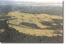 Mount Blackwood and lava ridge to south. |

© State of Victoria (Agriculture Victoria) 1996 - 2025.

This work, Victorian Resources Online, is licensed under a Creative Commons Attribution 4.0 licence. You are free to re-use the work under that licence, on the condition that you credit the State of Victoria (Agriculture Victoria) as author, indicate if changes were made and comply with the other licence terms.
The licence does not apply to ‘branding’ or some ‘images or photographs’ that may be owned by third parties. We ask you to seek prior approval to use images using the VRO feedback form. Access to higher quality images can also be provided on request.
This page was last updated on 23/11/2018.