
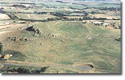
Mount Aitken
|
This information has been obtained from the report: Eruption Points of the Newer Volcanic Province of Victoria by Neville Rosengren. This report was published in 1994 and was prepared for the National Trust of Australia (Victoria) and the Geological Society of Australia (Victorian Division). The review of eruption points was based on an earlier unpublished manuscript Catalogue of the post-Miocene volcanoes of Victoria compiled by O P Singleton and E B Joyce (Geology Department, University of Melbourne 1970). |
| 37 33 00S 144 38 30E (external link); 7822-4-1 (SUNBURY) 916416. 8 km SE of Gisbourne. Calder Highway Lock Road. Gisbourne | 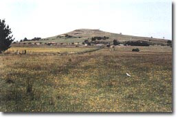 Mount Aitken | |
Moggs Hill | ||
Private land: | Vineyard, residence, grazing, abundant outcrop. | |
Type 9: | Composite lava and scoria volcano. Mount Aitken is the most prominent of a group of eroded volcanic hills in the Sunbury and Gisborne area. It is asymmetrical with a steep southern face with prominent parallel lava ridges, a small flattened summit with a shallow depression and a long gentle lava flow sloping to the north and west down to the level of the surrounding plain. Details of the geology are not known but the form of the hill suggests similarity with Mount Kororoit i.e. a scoria and lave core covered by final lava flows. The form of the volcano may be due to erosion of a scoria rim that once surrounded a lava-filled crater from which the lave tongue issued to the north. The removal of the scoria rim left the lava as a capping on the summit of the cone. | |
501 m; 75 m. | ||
State: | Mount Aitken is one of the best examples of this type of eroded volcano. It shows a stage in volcanic landform development that is not widely represented with erosion of a summit lava flow from a scoria cone. | |
References: | Edwards, A.B., 1938. The tertiary volcanic rocks of central Victoria. Quarterly journal of the Geological Society of London 94, pp. 243-320. Edwards, A.B. & Crawford, W., 1940. The Cainozoic volcanic rocks of the Gisbourne district, Victoria. Proceedings of the Royal Society of Victoria 52, pp. 281-311. | |
 Mount Aitken |

© State of Victoria (Agriculture Victoria) 1996 - .

This work, Victorian Resources Online, is licensed under a Creative Commons Attribution 4.0 licence. You are free to re-use the work under that licence, on the condition that you credit the State of Victoria (Agriculture Victoria) as author, indicate if changes were made and comply with the other licence terms.
The licence does not apply to ‘branding’ or some ‘images or photographs’ that may be owned by third parties. We ask you to seek prior approval to use images using the VRO feedback form. Access to higher quality images can also be provided on request.
This page was last updated on .