
LCA Cardinia Shire - Tech Report No. 29 - Chapter 4.6
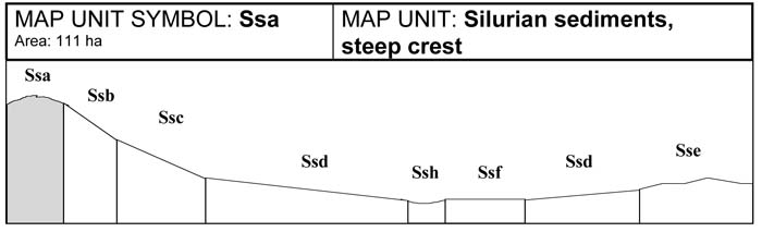
Ssa | Ssb | Ssc | Ssd | Sse | Ssf | Ssg | Ssh | Ssi
4.6 Silurian sedimentary map units (Ss)
The Silurian sedimentary landscape is limited to narrow bands south of Upper Beaconsfield, Pakenham Upper, and a strip running from Cockatoo North to Nangana. The sedimentary terrain ranges from steep rocky crests and highly dissected steep slopes near the metamorphic aureole, to low undulating hills and broader drainage depressions. Slopes range from 21-35 per cent, with an average gradient of 25 per cent in the steeper hill country, while in the low undulating hills, slopes range from 10-25 per cent, with an average gradient of 16 per cent.
Large areas of sedimentary material have been overlaid by volcanic material or have undergone metamorphism during igneous intrusions.
Grazing has taken place since early European settlement. Loss of vegetation cover through clearing, combined with periods of high grazing have modified the soils present. In many cases, erosion has removed much or all of the original topsoil, while cultivation has resulted in mixing of topsoil and subsoil. Many soil types present are considered to be modified soils and are likely to differ from undisturbed soils in their natural state.
Soils vary considerably due to marked changes in land use, topography and climate. Soil depth varies markedly, steep crests and slopes have shallow to very shallow soils while gentle crests have increased soil depth. The steep slopes are subject to significant erosion. Lower slopes are subject to a build up of colluvial material leading to the development of deeper soils. Flat areas and drainage depressions also have deep soils formed through alluvial deposition. In general, shallow stony brown Chromosol soils are common where rocky crests and steep rocky slopes occur. Weak, stony yellow Dermosol and Chromosol soils predominate where soil depth increases, especially when moderate slopes are encountered. Occasionally brown Chromosol and Dermosol soils occur in areas of good drainage. Surface stone is common on all crests and steep to moderate slopes.
Soils of the low undulating hills show less variation and soil depth regularly exceeds two metres in drainage lines. Soils present on gentle crests are mostly brown Chromosols . Where shallow rock outcrops, brown Dermosols may be present. Bleached, mottled brown Dermosol soils also dominate the very gentle slopes and broad drainage depressions. The presence of significant surface stone is restricted to isolated rocky crests and steep slopes.
Soils with bleached A2 horizons have high percentages of silt and fine sand. The A horizons therefore have low liquid limits, and when saturated these soils become sloppy and have little cohesive strength. If this horizon is exposed by the removal of vegetation and topsoil the A2 horizons are easily eroded.
On many of these units, excluding the flats and drainage depressions, a layer of stones exist in the A2 horizon and the top of the B1 horizon. These sedimentary stones appear as discreet layers, are generally angular in shape and range in size from 2-60 cm in diameter. Stone may comprise up to 80 per cent of the volume of the A2 horizon. Stones in the B2 horizon are well distributed, although there may be an accumulation of stones on top of the C horizon.
Various land degradation problems exist within this sedimentary landscape. In the steeper terrain, sheet and gully erosion occur where vegetation cover is sparse. The presence of highly fractured rock outcrop and shallow stony soils contributes to local and regional groundwater recharge. The sodic subsoils present in the low, undulating terrain have also contributed to significant gully erosion. Waterlogging is common along drainage lines and below leaking dams. In these situations, spiny rush is a good indicator of waterlogging and possible salinity.
Land management considerations
The steep sedimentary terrain, especially nearer the metamorphic aureole, has obvious hazards for all rural residential land uses. The major limitations are steep slopes, depth to hard rock and shallow soil depth. The steep terrain is highly susceptible to sheet and gully erosion, especially where vegetation cover is poor.
The siting of access tracks, building foundations, septic tanks and dams is made extremely difficult by steep slopes, depth to rock and shallow soils. Soil conservation measures will be required to minimise erosion during site construction.
The low undulating hills are more suited to a range of land uses. The major concerns include subsoil permeability and dispersibility. Shallow depth to hard rock may be a problem on crests.
With rural residential development rapidly increasing in these areas, careful design of effluent disposal fields, farm dams and secondary roading is required. Consideration must also be given to dam construction and the impact upon environmental streamflows.
Soil conditions do not favour intensive agriculture on these map units. Limitations on grazing are less severe and can be overcome with appropriate stocking rates and improved land management.
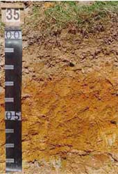 Plate 17 - Map Units" Ssa, Sse, Ssb - Brown Chromosol | 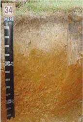 Plate 18 - Map Units: Ssc, Ssd, Ssf - Yellow Dermosol |
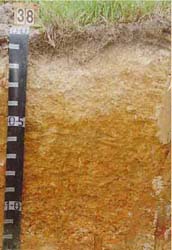 Plate 19 - Map nits: Ssh, Ssi, Ssg - Brown Chromosol |
A. GENERAL DESCRIPTION
Steep sedimentary crests occur in the north of the Shire adjacent to the granitic terrain. A shallow, stony brown Dermosol soil is common tending towards a yellow or brown Chromosol where soil depth increases. Soil depth varies from 50-120 cm in this unit. Surface rock is common and may cover 20 per cent of the surface in uncleared areas. Stone is common in the A2 horizon, usually at a depth of 25-30 cm. These stones cause significant problems in horticultural situations, however for construction and development they can be removed. The bleached A2 horizons have a high content of fine sand and silt. If these horizons are exposed, they will erode rapidly. After construction, vegetation should be replaced where possible.
SITE CHARACTERISTICS
| Parent Material Age: | Silurian | Depth to Seas. Watertable: | > 1.5 m | |
| Parent Material Lithology: | Sediments | Flooding Risk: | Nil | |
| Landform Pattern: | Rolling hills | Drainage: | Well drained | |
| Landform Element: | Crest | Rock Outcrop: | < 20% | |
| Slope a) common: | 7% | Depth to Hard Rock: | 0.5-1.3 m (variable) | |
| Slope b) range: | 3-15% | |||
| Potential Recharge to Groundwater: | High | |||
| Major Native Vegetation Species: | Narrow-leaved Peppermint, Long-leaved Box, Messmate | |||
| Present Land Use: | Grazing | |||
| Length of Growing Season: | 8 months | |||
LAND DEGRADATION
Degradation Processes | Water Erosion | Wind Erosion | Mass Movement | Salting | Acidification | |
sheet/rill | gully | |||||
Susceptibility | Low | Low | Very low | Very low | Low | Low |
Incidence | Low | Low | Very low | Low | Low | NA |
B. SOIL PROFILE
PROFILE DESCRIPTION
| Site S35 | ||
| A1 | 0-15 cm | Greyish brown (10YR5/2) silty loam, strong subangular blocky structure, peds 5-10 mm, rough fabric, firm consistence, a few medium (6-20 mm) subangular sedimentary pebbles, pH 6.0. Clear transition to: |
| A2 | 15-30 cm | Reddish yellow (7.5YR6/6) silty clay loam, moderate polyhedral structure, peds 20-50 mm rough fabric, weak consistence, many large subrounded sedimentary pebbles, pH 6.2. Gradual transition to: |
| B2 | 30-90 cm | Strong brown (7.5YR5/6) light medium clay, many coarse distinct yellowish red mottles, strong subangular blocky structure, peds 5-10 mm, smooth fabric, very firm consistence, large (20-60 mm) subrounded sedimentary pebbles are common, pH 5.9. Gradual transition to: |
| C | 90+ cm | Weathered sedimentary rock. |
Classification
| Factual Key: | Gn3.84 (major), Dy3.41 (minor) |
| Australian Soil Classification: | Mottled, Magnesic, Brown DERMOSOL; thick, gravelly, silty/clayey, moderate (confidence level 2) |
| Unified Soil Group: | CH |
Interpretation of Laboratory ANAlysis*
Horizon | pH (CaCl2) | % Gravel | EC (salts) | Nutrient Status | P | K | Al | Organic Matter | Dispersibility |
A1 | 5.5 | 17 | VL | M | S | S | S | H | VL |
A2 | 5.5 | 20 | VL | L | D | S | S | L | L |
B2 | 5.5 | 12 | VL | M | D | S | S | VL | L |
T: Potentially Toxic NA: Not Available * see Appendix D for analytical results ** Strongly Acidic
Soil Profile Characteristics:
| Permeability: | Moderate (average 130 mm/day, range 15-260 mm/day) |
| Available Water Capacity: | Moderate (135 mm H2O) |
| Linear Shrinkage (B horizon): | Low (12%) |
C. LAND CAPABILITY ASSESSMENT
| Land Use | Class | Major Limiting Feature(s)/Land Use |
| Agriculture | C2T2S3-4 | Depth to hardrock (variable) |
| Effluent Disposal (septic tanks) | 3-4 | Depth to impermeable layer (variable) |
| Farm Dams | 4-5 | Depth to hardrock (variable) |
| Building Foundations slab stumps/footings | 3 3-2 | Slope Depth to hardrock (variable) |
| Secondary Roads | 3 | Slope, proportion of stones and boulders, USG |
| Rural Residential Development | 4-5 | Farm dams |
A. GENERAL DESCRIPTION
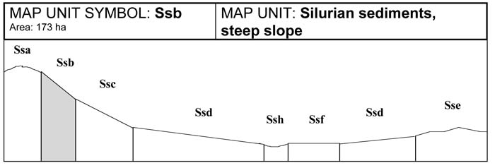
Steep sedimentary slopes are present adjacent to the granitic terrain in the north of the Shire. Soils are similar to those of the crests (Ssa) situated above them, with stony Brown Dermosol soils common, and occasional brown Chromosol and yellow Dermosol soils present. Soil depth may vary from 50-100 cm. These slopes are prone to sheet erosion. Rock outcrop is common on these slopes. A stone layer is common in the A2 horizon or on top of the B1 horizon.
SITE CHARACTERISTICS
| Parent Material Age: | Silurian | Depth to Seas. Watertable: | > 1.3 m | |
| Parent Material Lithology: | Sediments | Flooding Risk: | Nil | |
| Landform Pattern: | Rolling hills | Drainage: | Well drained | |
| Landform Element: | Hillslope | Rock Outcrop: | < 30% | |
| Slope a) common: | 35% | Depth to Hard Rock: | 0.5-1.3 m | |
| Slope b) range: | > 33% | |||
| Potential Recharge to Groundwater: | High | |||
| Major Native Vegetation Species: | Narrow-leaved Peppermint, Long-leaved Box, Messmate | |||
| Present Land Use: | Grazing | |||
| Length of Growing Season: | 8 months | |||
LAND DEGRADATION
Degradation Processes | Water Erosion | Wind Erosion | Mass Movement | Salting | Acidification | |
sheet/rill | gully | |||||
Susceptibility | High | Moderate | Very low | High | Low | Low |
Incidence | High | Moderate | Low | Low | Low | NA |
B. SOIL PROFILE
PROFILE DESCRIPTION
| Site S35 | ||
| A1 | 0-10 cm | Greyish brown (10YR5/2) silty loam, strong subangular blocky structure, peds 5-10 mm, rough fabric, firm consistence, few medium (6-20 mm) subangular sedimentary pebbles, pH 6.0. Clear transition to: |
| A2 | 10-30 cm | Reddish yellow (7.5YR6/6) silty clay loam, moderate polyhedral structure, peds 20-50 mm, rough fabric, weak consistence, many large subrounded sedimentary pebbles, pH 6.2. Gradual transition to: |
| B2 | 30-85 cm | Strong brown (7.5YR5/6) light medium clay, many coarse distinct yellowish red mottles, strong subangular blocky structure, peds 5-10 mm, smooth fabric, very firm consistence, large (20-60 mm) subrounded sedimentary pebbles are common, pH 5.9. Gradual transition to: |
| C | 85+ cm | Weathered sedimentary rock. |
Classification
| Factual Key: | Gn3.84 (major), Dy3.41 (minor) |
| Australian Soil Classification: | Mottled, Magnesic, Brown DERMOSOL; thick, gravelly, silty/clayey, moderate (confidence level 2) |
| Unified Soil Group: | CH |
Interpretation of Laboratory ANAlysis*
Horizon | pH (CaCl2) | % Gravel | EC (salts) | Nutrient Status | P | K | Al | Organic Matter | Dispersibility |
A1 | 5.5 | 17 | VL | M | S | S | S | H | VL |
A2 | 5.5 | 20 | VL | L | D | S | S | L | L |
B2 | 5.5 | 12 | VL | M | D | S | S | VL | L |
VL: Very low L: Low M: Moderate H: High VH: Very high D: Deficient S: Satisfactory
T: Potentially Toxic NA: Not Available * see Appendix D for analytical results ** Strongly Acidic
Soil Profile Characteristics:
| Permeability: | Moderate (average 130 mm/day, range 15-260 mm/day) |
| Available Water Capacity: | Moderate (130 mm H2O) |
| Linear Shrinkage (B horizon): | Low (12%) |
C. LAND CAPABILITY ASSESSMENT
| Land Use | Class | Major Limiting Feature(s)/Land Use |
| Agriculture | C2T5S4 | Steep slope |
| Effluent Disposal (septic tanks) | 5 | Steep slope |
| Farm Dams | 5 | Steep slope |
| Building Foundations slab stumps/footings | 5 4 | Steep slope Steep slope, susceptibility to slope failure |
| Secondary Roads | 5 | Steep slope |
| Rural Residential Development | 5 | Secondary roads, farm dams, effluent disposal, building foundations (slab) |
A. GENERAL DESCRIPTION
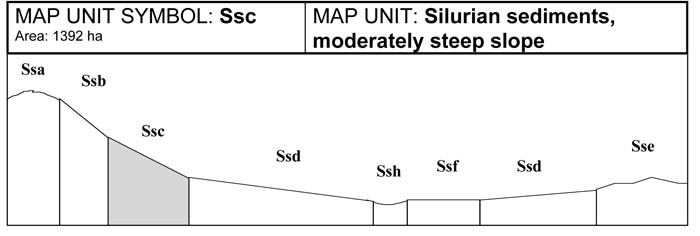
Moderately steep slopes are found mostly in the north of the Shire near the metamorphic aureole. Stony yellow Dermosol soils with bleached A2 horizons are common; minor soil types include yellow and brown Chromosols. Soil depth is between 75-130 cm. These slopes are prone to sheet and rill erosion. A stone layer is common in the A2 horizon or on top of the B1 horizon. The fine sandy or silty A2 horizon has very weak structure which breaks down readily when excess water is added, making these slopes prone to sheet and rill erosion if the A2 horizon is exposed.
SITE CHARACTERISTICS
| Parent Material Age: | Silurian | Depth to Seas. Watertable: | > 1.5 m | |
| Parent Material Lithology: | Sediments | Flooding Risk: | Nil | |
| Landform Pattern: | Rolling hills | Drainage: | Well drained | |
| Landform Element: | Hillslope | Rock Outcrop: | 20% | |
| Slope a) common: | 25% | Depth to Hard Rock: | 0.5-1.3 m (variable) | |
| Slope b) range: | 21-32% | |||
| Potential Recharge to Groundwater: | Moderate | |||
| Major Native Vegetation Species: | Narrow-leaved Peppermint, Long-leaved Box, Messmate | |||
| Present Land Use: | Grazing | |||
| Length of Growing Season: | 8 months | |||
LAND DEGRADATION
Degradation Processes | Water Erosion | Wind Erosion | Mass Movement | Salting | Acidification | |
sheet/rill | gully | |||||
Susceptibility | Moderate | Low | Moderate | Moderate | Low | Low |
Incidence | Moderate | Moderate | Low | Low | Low | NA |
B. SOIL PROFILE
PROFILE DESCRIPTION
| Site S34 | ||
| A1 | 0-10 cm | Brown (10YR5/2) silty loam, moderate polyhedral structure, peds 10-20 mm, rough fabric, firm consistence, pH 5.5. Abrupt transition to: |
| A2 | 10-40 cm | Brown (7.5YR5/4) light clay, bleached (10YR8/2) when dry, a few coarse faint brownish yellow mottles, moderate polyhedral structure, rough fabric, peds 10-20 mm, firm consistence, a few large subrounded sedimentary pebbles, pH 5.7. Gradual transition to: |
| B21 | 40-70 cm | Brownish yellow (10YR6/6) heavy clay, coarse prominent yellowish red mottles are common, moderate polyhedral structure, peds 2-5 mm, rough fabric, firm consistence, a few large subrounded sedimentary pebbles, pH 5.8. Gradual transition to: |
| B22 | 70-110 cm | Light yellowish brown (10YR6/4) heavy clay, many very coarse prominent yellowish red mottles and very coarse distinct pale brown mottles, moderate polyhedral structure, peds 2-5 mm, rough fabric, firm consistence, a few large subrounded sedimentary pebbles, pH 6.2. Gradual transition to: |
| C | 110+ cm | Weathering sedimentary rock. |
Classification
| Factual Key: | Gn4.64 (major), Dy3.41 (minor) |
| Australian Soil Classification: | Bleached-Sodic, Magnesic, Yellow DERMOSOL; thick, slightly gravelly, silty/clayey, deep (confidence level 2) |
| Unified Soil Group: | CH |
Interpretation of Laboratory ANAlysis*
Horizon | pH (CaCl2) | % Gravel | EC (salts) | Nutrient Status | P | K | Al | Organic Matter | Dispersibility |
A1 | 4.6 | 8 | VL | L | D | D | T | H | VL |
A2 | 4.6 | 18 | VL | VL | D | D | S | VL | VL |
B21 | 4.7 | 7 | VL | M | D | D | S | VL | VL |
B22 | 5.4 | 5 | VL | M | D | D | S | VL | L |
T: Potentially Toxic NA: Not Available * see Appendix D for analytical results ** Strongly Acidic
Soil Profile Characteristics:
| Permeability: | Moderate (average 155 mm/day, range 90-300 mm/day) |
| Available Water Capacity: | Moderate (150 mm H2O) |
| Linear Shrinkage (B horizon): | Moderate (16.5%) |
C. LAND CAPABILITY ASSESSMENT
| Land Use | Class | Major Limiting Feature(s)/Land Use |
| Agriculture | C2T4S3-4 | Slope |
| Effluent Disposal (septic tanks) | 4 | Slope |
| Farm Dams | 5 | Slope |
| Building Foundations slab stumps/footings | 4 3 | Slope Slope, susceptibility to slope failure, linear shrinkage |
| Secondary Roads | 4 | Slope |
| Rural Residential Development | 5 | Farm dams |
A. GENERAL DESCRIPTION
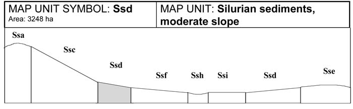
This unit occurs where there is a noticeable break between steep and gentle slopes. These moderate slopes are found throughout the sedimentary terrain. Under normal circumstances colluvial material accumulates at the bottom of these moderate slopes leading to much variation in soil development. The dominant soil type is a mottled yellow Dermosol soil with a bleached A2 horizon, however brown Dermosols and yellow Chromosols will occur where soil depth varies. A stone layer is common in the A2 horizon or on the top of the B1 horizon. The fine sandy or silty A2 horizon has a very weak structure which breaks down readily when excess water is added, making these slopes prone to sheet and rill erosion if the A2 horizon is exposed. Minor drainage lines in this unit may suffer from gully erosion.
SITE CHARACTERISTICS
| Parent Material Age: | Silurian | Depth to Seas. Watertable: | > 1.3 m | |
| Parent Material Lithology: | Sediments | Flooding Risk: | Nil | |
| Landform Pattern: | Rolling hills | Drainage: | Well drained | |
| Landform Element: | Hillslope | Rock Outcrop: | < 10% | |
| Slope a) common: | 16% | Depth to Hard Rock: | 0.8-1.5 m | |
| Slope b) range: | 11-20% | |||
| Potential Recharge to Groundwater: | Moderate | |||
| Major Native Vegetation Species: | Narrow-leaved Peppermint, Long-leaved Box, Messmate | |||
| Present Land Use: | Grazing | |||
| Length of Growing Season: | 8 months | |||
LAND DEGRADATION
Degradation Processes | Water Erosion | Wind Erosion | Mass Movement | Salting | Acidification | |
sheet/rill | gully | |||||
Susceptibility | Moderate | Low | Moderate | Moderate | Low | Low |
Incidence | Moderate | Moderate | Low | Low | Low | NA |
B. SOIL PROFILE
PROFILE DESCRIPTION
| Site S34 | ||
A1 | 0-10 cm | Brown (10YR5/2) silty loam, moderate polyhedral structure, peds 10-20 mm, rough fabric, firm consistence, pH 5.5. Abrupt transition to: |
A2 | 10-40 cm | Brown (7.5YR5/4) light clay, bleached (10YR8/2) when dry, a few coarse faint brownish yellow mottles, moderate polyhedral structure, rough fabric, peds 10-20 mm, firm consistence, a few large subrounded sedimentary pebbles, pH 5.7. Gradual transition to: |
B21 | 40-70 cm | Brownish yellow (10YR6/6) heavy clay, coarse prominent yellowish red mottles are common, moderate polyhedral structure, peds 2-5 mm, rough fabric, firm consistence, a few large subrounded sedimentary pebbles, pH 5.8. Gradual transition to: |
B22 | 70-115 cm | Light yellowish brown (10YR6/4) heavy clay, many very coarse prominent yellowish red mottles and many very coarse distinct pale brown mottles, moderate polyhedral structure, peds 2-5 mm, rough fabric, firm consistence, a few large subrounded sedimentary pebbles, pH 6.2. Gradual transition to: |
C | 115 cm | Weathered sedimentary rock. |
Classification
| Factual Key: | Gn4.64 (major), Dy3.41 (minor) |
| Australian Soil Classification: | Bleached-Sodic, Magnesic, Yellow DERMOSOL; thick, slightly gravelly, silty/clayey, deep (confidence level 2) |
| Unified Soil Group: | CH |
Interpretation of Laboratory ANAlysis*
Horizon | pH (CaCl2) | % Gravel | EC (salts) | Nutrient Status | P | K | Al | Organic Matter | Dispersibility |
A1 | 4.6 | 8 | VL | L | D | D | T | H | VL |
A2 | 4.6 | 18 | VL | VL | D | D | S | VL | VL |
B1 | 4.7 | 7 | VL | M | D | D | S | VL | VL |
B2 | 5.4 | 5 | VL | M | D | D | S | VL | L |
VL: Very low L: Low M: Moderate H: High VH: Very high D: Deficient S: Satisfactory
T: Potentially Toxic NA: Not Available * see Appendix D for analytical results ** Strongly Acidic
Soil Profile Characteristics:
| Permeability: | Moderate (average 155 mm/day, range 90-300 mm/day) |
| Available Water Capacity: | Moderate - High (150 mm H2O) |
| Linear Shrinkage (B horizon): | Moderate (16.5%) |
C. LAND CAPABILITY ASSESSMENT
| Land Use | Class | Major Limiting Feature(s)/Land Use |
| Agriculture | C2T3S3 | Slope, topsoil condition (A2), available water capacity, susceptibility to sheet erosion, susceptibility to sheet and wind erosion |
| Effluent Disposal (septic tanks) | 3-4 | Depth to impermeable layer (variable) |
| Farm Dams | 4-5 | Depth to hardrock (variable) |
| Building Foundations slab stumps/footings | 4 3 | Slope Slope, susceptibility to slope failure, linear shrinkage |
| Secondary Roads | 4 | Slope |
| Rural Residential Development | 4-5 | Secondary roads, farm dams, building foundations (slab) |
A. General Description
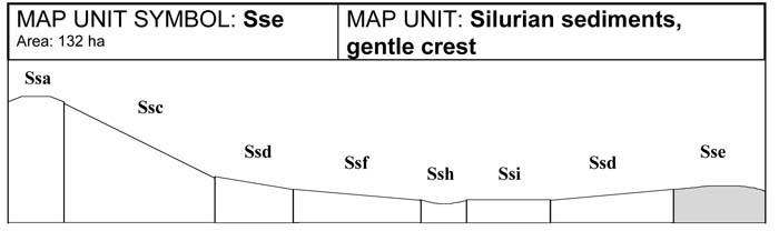
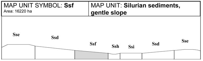
Gentle sedimentary crests are common throughout the Shire. Soils are shallow with surface rock common in some areas. Stony, mottled brown Dermosols are the dominant soils and usually contain a distinct bleached A2 horizon. Brown Chromosols may be present where soils are deeper. These soils generally have a stone layer in the A2 at about 25-30 cm in depth. Bleached A2 horizons have poor structure, however erosion is limited on this unit because of the gentle slopes.
SITE CHARACTERISTICS
| Parent Material Age: | Silurian | Depth to Seas. Watertable: | > 1.5 m | |
| Parent Material Lithology: | Sediments | Flooding Risk: | Nil | |
| Landform Pattern: | Low hills | Drainage: | Well drained | |
| Landform Element: | Crest | Rock Outcrop: | 0-20% | |
| Slope a) common: | 4% | Depth to Hard Rock: | 0.75-1.3 m (variable) | |
| Slope b) range: | 2-7% | |||
| Potential Recharge to Groundwater: | High | |||
| Major Native Vegetation Species: | Narrow-leaved Peppermint, Long-leaved Box, Messmate | |||
| Present Land Use: | Grazing | |||
| Length of Growing Season: | 8 months | |||
LAND DEGRADATION
Degradation Processes | Water Erosion | Wind Erosion | Mass Movement | Salting | Acidification | |
sheet/rill | gully | |||||
Susceptibility | Low | Low | Very low | Very low | Low | Low |
Incidence | Low | Low | Very low | Very low | Low | NA |
B. SOIL PROFILE
PROFILE DESCRIPTION
| Site S35 | ||
A1 | 0-15 cm | Greyish brown (10YR5/2) silty loam, strong subangular blocky structure, peds 5-10 mm, rough fabric, firm consistence, a few medium (6-20 mm) subangular sedimentary pebbles, pH 6.0. Clear transition to: |
A2 | 15-30 cm | Reddish yellow (7.5YR6/6) silty clay loam, moderate polyhedral structure, peds 20-50 mm, rough fabric, weak consistence, many large subrounded sedimentary pebbles, pH 6.2. Gradual transition to: |
B2 | 30-90 cm | Strong brown (7.5YR5/6) light medium clay, many coarse distinct yellowish red mottles, strong subangular blocky structure, peds 5-10 mm, smooth fabric, very firm consistence, large (20-60 mm) subrounded sedimentary pebbles are common, pH 5.9. Gradual transition to: |
C | 90+ cm | Weathered sedimentary rock. |
Classification
| Factual Key: | Gn3.74 (major) Dy3.41 (minor) |
| Australian Soil Classification: | Mottled, Magnesic Brown DERMOSOL; thick, gravelly, silty/clayey, moderate (confidence level 2) |
| Unified Soil Group: | CH |
Interpretation of Laboratory ANAlysis*
Horizon | pH (CaCl2) | % Gravel | EC (salts) | Nutrient Status | P | K | Al | Organic Matter | Dispersibility |
A1 | 5.5 | 17 | VL | M | S | S | S | H | VL |
A2 | 5.5 | 20 | VL | L | D | S | S | L | L |
B2 | 5.5 | 12 | VL | M | D | S | S | VL | L |
T: Potentially Toxic NA: Not Available * see Appendix D for analytical results ** Strongly Acidic
Soil Profile Characteristics:
| Permeability: | Moderate (average 130 mm/day, range 15-260 mm/day) |
| Available Water Capacity: | Moderate (115 mm H2O) |
| Linear Shrinkage (B horizon): | Low (12%) |
C. LAND CAPABILITY ASSESSMENT
| Land Use | Class | Major Limiting Feature(s)/Land Use |
| Agriculture | C2T2S3 | Available water capacity, gravel/stone/boulder content |
| Effluent Disposal (septic tanks) | 3 | Depth to impermeable layer |
| Farm Dams | 4 | Depth to hardrock, permeability, dispersibility of subsoil |
| Building Foundations slab stumps/footings | 2 2 | Nil Nil |
| Secondary Roads | 3 | Proportion of stones and boulders, USG |
| Rural Residential Development | 4 | Farm dams |
A. GENERAL DESCRIPTION
The gentle sedimentary slopes are common throughout the sedimentary area. The dominant soil type is a yellow Dermosol with a bleached A2 horizon and a mottled light medium to heavy clay subsoil. This unit may have a deeper soil profile due to to the deposition of colluvial material. These slopes are less prone to erosion, but may become waterlogged lower in the landscape or adjacent to drainage depressions.
SITE CHARACTERISTICS
| Parent Material Age: | Silurian | Depth to Seas. Watertable: | > 1.5 m | |
| Parent Material Lithology: | Sediments | Flooding Risk: | Very low | |
| Landform Pattern: | Low hills | Drainage: | Imperfectly drained | |
| Landform Element: | Hillslope | Rock Outcrop: | < 5% | |
| Slope a) common: | 7% | Depth to Hard Rock: | > 1.5 m | |
| Slope b) range: | 4-10% | |||
| Potential Recharge to Groundwater: | Low | |||
| Major Native Vegetation Species: | Narrow-leaved Peppermint, Long-leaved Box, Messmate | |||
| Present Land Use: | Grazing | |||
| Length of Growing Season: | 8 months | |||
LAND DEGRADATION
Degradation Processes | Water Erosion | Wind Erosion | Mass Movement | Salting | Acidification | |
sheet/rill | gully | |||||
Susceptibility | Low | Low | Low | Very low | Low | Low |
Incidence | Low | Low | Low | Very low | Low | NA |
B. SOIL PROFILE
PROFILE DESCRIPTION
| Site S34 | ||
A1 | 0-10 cm | Brown (10YR5/2) silty loam, moderate polyhedral structure, peds 10-20 mm, rough fabric, firm consistence, pH 5.5. Abrupt transition to: |
A2 | 10-40 cm | Brown (7.5YR5/4) light clay, bleached (10YR8/2) when dry, a few coarse faint brownish yellow mottles, moderate polyhedral structure, rough fabric, peds 10-20 mm, firm consistence, a few large subrounded sedimentary pebbles, pH 5.7. Gradual transition to: |
B1 | 40-75 cm | Yellowish brown (10YR6/6) heavy clay, coarse prominent yellowish red mottles are common, moderate polyhedral structure, peds 2-5 mm, rough fabric, firm consistence, a few large subrounded sedimentary pebbles, pH 5.8. Gradual transition to: |
B2 | 75-115 cm | Light yellowish brown (10YR6/4) heavy clay, many very coarse prominent yellowish red mottles and many very coarse distinct pale brown mottles, moderate polyhedral structure, peds 2-5 mm, rough fabric, firm consistence, a few large subrounded sedimentary pebbles, pH 6.2. Gradual transition to: |
C | 115+ cm | Weathered sedimentary rock. |
Classification
| Factual Key: | Gn4.64 (major) Dy3.41(minor) |
| Australian Soil Classification: | Bleached-Sodic, Magnesic, Yellow DERMOSOL; thick, slightly gravelly, silty/clayey, deep |
| Unified Soil Group: | CH |
Interpretation of Laboratory ANAlysis*
Horizon | pH (CaCl2) | % Gravel | EC (salts) | Nutrient Status | P | K | Al | Organic Matter | Dispersibility |
A1 | 4.6 | 8 | VL | L | D | D | T | H | VL |
A2 | 4.6 | 18 | VL | VL | D | D | S | VL | VL |
B1 | 4.7 | 7 | VL | M | D | D | S | VL | VL |
B2 | 5.4 | 5 | VL | M | D | D | S | VL | L |
T: Potentially Toxic NA: Not Available * see Appendix D for analytical results ** Strongly Acidic
Soil Profile Characteristics:
| Permeability: | Moderate (average 155 mm/day, range 90-300 mm/day) |
| Available Water Capacity: | Moderate (150 mm H2O) |
| Linear Shrinkage (B horizon): | Moderate (16.5%) |
C. LAND CAPABILITY ASSESSMENT
| Land Use | Class | Major Limiting Feature(s)/Land Use |
| Agriculture | C2T2S3 | Condition of topsoil (A2), available water capacity |
| Effluent Disposal (septic tanks) | 4 | Drainage |
| Farm Dams | 4 | Permeability |
| Building Foundations slab stumps/footings | 4 4 | Drainage Drainage |
| Secondary Roads | 4 | Drainage |
| Rural Residential Development | 4 | Secondary roads, farm dams, effluent disposal, building foundations |
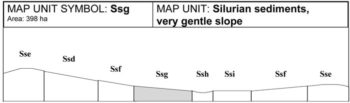
A. GENERAL DESCRIPTION
The very gentle sedimentary slopes have similar soils to the flats (Ssi). Bleached and mottled, brown Chromosol soils are common. Drainage of these soils is slow, and waterlogging is common in winter and spring. Soil depth is greater on these slopes and may reach 1.5 metres. The bleached A2 horizons are susceptible to erosion, but sheet and rill erosion are less common because of the gentle slopes. Gully erosion is also present.
SITE CHARACTERISTICS
| Parent Material Age: | Silurian | Depth to Seas. Watertable: | > 1.5 m | |
| Parent Material Lithology: | Sediments | Flooding Risk: | Low | |
| Landform Pattern: | Low hills | Drainage: | Imperfectly drained | |
| Landform Element: | Hillslope | Rock Outcrop: | < 5% | |
| Slope a) common: | 2% | Depth to Hard Rock: | > 1.5 m | |
| Slope b) range: | 1-3% | |||
| Potential Recharge to Groundwater: | Low | |||
| Major Native Vegetation Species: | Narrow-leaved Peppermint, Long-leaved Box, Messmate | |||
| Present Land Use: | Grazing | |||
| Length of Growing Season: | 8 months | |||
LAND DEGRADATION
Degradation Processes | Water Erosion | Wind Erosion | Mass Movement | Salting | Acidification | |
sheet/rill | gully | |||||
Susceptibility | Low | Low | Low | Very low | Low | Low |
Incidence | Low | Low | Low | Very low | Low | NA |
B. SOIL PROFILE
PROFILE DESCRIPTION
| SITE S38 | ||
A1 | 0-10 cm | Dark greyish brown (10YR4/2) silty loam, moderate structure, peds 5-10 mm, rough fabric, weak consistence, pH 6.1. Abrupt transition to: |
A2 | 10-40 cm | Very pale brown (10YR7/3) sandy clay loam fine sandy, bleached (10YR8/2) when dry, coarse faint very pale brown mottles are common, weak subangular blocky structure, peds 10-20 mm, rough fabric, firm consistence, very few large subrounded and rounded sedimentary pebbles, pH 6.1. Clear transition to: |
B21 | 40-80 cm | Light yellowish brown (7.5YR5/6) medium clay, many medium faint red and orange mottles, strong polyhedral structure, peds 2-5 mm, smooth fabric, firm consistence, subrounded sedimentary stones are common, pH 5.9. Gradual transition to: |
B22 | 80-110 cm | Yellowish brown (10YR5/4) medium clay, many coarse prominent red mottles and medium faint orange mottles, strong polyhedral structure, peds 20-50 mm, breaking down to 2-5 mm, smooth fabric, firm consistence, pH 6.1. Gradual transition to: |
C | 110-145+ cm | Weathered sedimentary rock. |
Classification
| Factual Key: | Dy3.41 (major), Gn3.84 (minor) |
| Australian Soil Classification: | Bleached-Sodic, Magnesic, Brown CHROMOSOL; thick, slightly gravelly, silty/clayey, deep |
| Unified Soil Group: | CH |
Interpretation of Laboratory ANAlysis*
Horizon | pH (CaCl2) | % Gravel | EC (salts) | Nutrient Status | P | K | Al | Organic Matter | Dispersibility |
A1 | 5.0 | 3 | VL | L | D | D | S | H | VL |
A2 | 4.9 | 15 | VL | VL | D | D | S | VL | L |
B21 | 4.7 | 11 | VL | M | D | D | T | VL | VL |
B22 | 5.0 | 10 | VL | M | D | D | S | VL | L |
T: Potentially Toxic NA: Not Available * see Appendix D for analytical results ** Strongly Acidic
Soil Profile Characteristics:
| Permeability: | Slow (average 15 mm/day, range 10-25 mm/day) |
| Available Water Capacity: | High (155 mm H2O) |
| Linear Shrinkage (B horizon): | Moderate (17%) |
C. LAND CAPABILITY ASSESSMENT
| Land Use | Class | Major Limiting Feature(s)/Land Use |
| Agriculture | C2T1S3 | Condition of topsoil (A2), permeability-rainfall index |
| Effluent Disposal (septic tanks) | 4 | Drainage, slow permeability |
| Farm Dams | 3 | Low dispersibility of subsoil, linear shrinkage, permeability, suitability of subsoil, depth to seasonal watertable, depth to hardrock |
| Building Foundations slab stumps/footings | 4 4 | Drainage Drainage |
| Secondary Roads | 4 | Drainage |
| Rural Residential Development | 4 | Secondary roads, effluent disposal, building foundations |
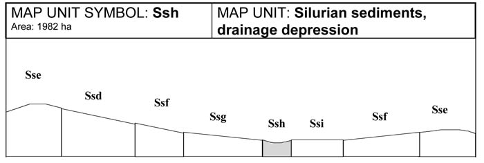
A. GENERAL DESC RIPTION
Drainage lines running through sedimentary terrain are generally wide and contain soils greater than two metres in depth. In many situations minor drainage lines may not have been mapped due to restrictions of scale, especially in steeper units. Bleached and mottled, brown Chromosol soils are common. Salting and gully erosion occur in this unit. Seasonal flooding is common. Waterlogging is a problem in winter and spring.
SITE CHARACTERISTICS
| Parent Material Age: | Silurian | Depth to Seas. Watertable: | > 1.5 m | |
| Parent Material Lithology: | Sediments | Flooding Risk: | Moderate | |
| Landform Pattern: | Low hills | Drainage: | Imperfectly drained | |
| Landform Element: | Drainage depression | Rock Outcrop: | Nil | |
| Slope a) common: | 3% | Depth to Hard Rock: | > 1.5 m | |
| Slope b) range: | 0-7% | |||
| Potential Recharge to Groundwater: | Low | |||
| Major Native Vegetation Species: | Narrow-leaved Peppermint, Long-leaved Box, Messmate | |||
| Present Land Use: | Grazing | |||
| Length of Growing Season: | 8 months | |||
LAND DEGRADATION
Degradation Processes | Water Erosion | Wind Erosion | Mass Movement | Salting | Acidification | |
sheet/rill | gully | |||||
Susceptibility | Low | Low | Low | Very low | Moderate | Low |
Incidence | Low | Moderate | Low | Very low | Low | NA |
B. SOIL PROFILE
PROFILE DESCRIPTION
| Site S38 | ||
A1 | 0-10 cm | Dark greyish brown (10YR4/2) silty loam, moderate structure, peds 5-10 mm, rough fabric, weak consistence, pH 6.1. Abrupt transition to: |
A2 | 10-40 cm | Very pale brown (10YR7/3) sandy clay loam fine sandy, bleached (10YR8/2) when dry, coarse faint very pale brown mottles are common, weak subangular blocky structure, peds 10-20 mm, rough fabric, firm consistence, very few large subrounded and rounded sedimentary pebbles, pH 6.1. Clear transition to: |
B21 | 40-80 cm | Light yellowish brown (7.5YR5/6) medium clay, many medium faint red and orange mottles, strong polyhedral structure, peds 2-5 mm, smooth fabric, firm consistence, subrounded sedimentary stones are common, pH 5.9. Gradual transition to: |
B22 | 80-110 cm | Yellowish brown (10YR5/4) medium clay, many coarse prominent red mottles and medium faint orange mottles, strong polyhedral structure, peds 20-50 mm, breaking down to 2-5 mm, smooth fabric, firm consistence, pH 6.1. Gradual transition to: |
C | 110-145+ cm | Weathered sedimentary rock. |
Classification
| Factual Key: | Dy3.41 (major), Gn3.84 (minor) |
| Australian Soil Classification: | Bleached-sodic, Magnesic, Brown CHROMOSOL; thick, slightly gravelly, silty/clayey, deep (confidence level 2) |
| Unified Soil Group: | CH |
Interpretation of Laboratory ANAlysis*
Horizon | pH (CaCl2) | % Gravel | EC (salts) | Nutrient Status | P | K | Al | Organic Matter | Dispersibility |
A1 | 5.0 | 3 | VL | L | D | D | S | H | VL |
A2 | 4.9 | 15 | VL | VL | D | D | S | VL | L |
B21 | 4.7 | 11 | VL | M | D | D | S | VL | VL |
B22 | 5.0 | 10 | VL | M | D | D | S | VL | L |
T: Potentially Toxic NA: Not Available * see Appendix D for analytical results ** Strongly Acidic
Soil Profile Characteristics:
| Permeability: | Slow (average 15 mm/day, range 10-25 mm/day) |
| Available Water Capacity: | High (160 mm H2O) |
| Linear Shrinkage (B horizon): | Moderate (17%) |
C. LAND CAPABILITY ASSESSMENT
| Land Use | Class | Major Limiting Feature(s)/Land Use |
| Agriculture | C2T1S3 | Topsoil condition (A2), permeability-rainfall index |
| Effluent Disposal (septic tanks) | 4 | Imperfect drainage, slow permeability |
| Farm Dams | 3 | Linear shrinkage, permeability, dispersibility of subsoil, depth to hardrock, suitability of subsoil, depth to seasonal watertable |
| Building Foundations slab stumps/footings | 4 4 | Drainage Drainage |
| Secondary Roads | 4 | Drainage |
| Rural Residential Development | 4 | Secondary roads, effluent disposal, building foundations |
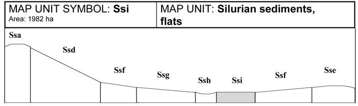
A. GENERAL DESCRIPTION
Flats are associated with some of the major drainage lines in the gently undulating sedimentary areas, especially in the north of the Shire around Nangana. Soils of this unit have been subjected to some alluvial and colluvial build-up, and may exceed two metres in depth. Soils are generally brown Chromosols with bleached A2 horizons. These soils may be waterlogged for a number of months during the year, flooding may also occur. In many situations, minor flats may not have been mapped due to restrictions of scale.
SITE CHARACTERISTICS
| Parent Material Age: | Silurian | Depth to Seas. Watertable: | > 1.5 m | |
| Parent Material Lithology: | Sediments | Flooding Risk: | Moderate | |
| Landform Pattern: | Low hills | Drainage: | Imperfectly drained | |
| Landform Element: | Flat | Rock Outcrop: | Nil | |
| Slope a) common: | 1% | Depth to Hard Rock: | > 1.5 m | |
| Slope b) range: | 0-1% | |||
| Potential Recharge to Groundwater: | Low | |||
| Major Native Vegetation Species: | Narrow-leaved Peppermint, Long-leaved Box, Messmate | |||
| Present Land Use: | Grazing | |||
| Length of Growing Season: | 8 months | |||
LAND DEGRADATION
Degradation Processes | Water Erosion | Wind Erosion | Mass Movement | Salting | Acidification | |
sheet/rill | gully | |||||
Susceptibility | Low | Low | Low | Very low | Low | Low |
Incidence | Low | Low | Low | Very low | Low | NA |
B. SOIL PROFILE
PROFILE DESCRIPTION
| Site 38 | ||
A1 | 0-10 cm | Dark greyish brown (10YR4/2) silty loam, moderate structure, peds 5-10 mm, rough fabric, weak consistence, pH 6.1. Abrupt transition to: |
A2 | 10-40 cm | Very pale brown (10YR7/3) sandy clay loam fine sandy, bleached (10YR8/2) when dry, coarse faint very pale brown mottles are common, weak subangular blocky structure, peds 10-20 mm, rough fabric, firm consistence, very few large subrounded and rounded sedimentary pebbles, pH 6.1. Clear transition to: |
B21 | 40-80 cm | Light yellowish brown (7.5YR5/6) medium clay, many medium faint red and orange mottles, strong polyhedral structure, peds 2-5 mm, smooth fabric, firm consistence, subrounded sedimentary stones are common, pH 5.9. Gradual transition to: |
B22 | 80-110 cm | Yellowish brown (10YR5/4) medium clay, many coarse prominent red mottles and medium faint orange mottles, strong polyhedral structure, peds 20-50 mm, breaking down to 2-5 mm, smooth fabric, firm consistence, pH 6.1. Gradual transition to: |
C | 110-145+ cm | Weathered sedimentary rock. |
Classification
| Factual Key: | Dy3.41 (major), Dy3.81, Dy3.11(minor) |
| Australian Soil Classification: | Bleached-Sodic, Magnesic, Brown CHROMOSOL; thick slightly gravelly, silty/clayey, deep (confidence level 2) |
| Unified Soil Group: | CH |
Interpretation of Laboratory ANAlysis*
Horizon | pH (CaCl2) | % Gravel | EC (salts) | Nutrient Status | P | K | Al | Organic Matter | Dispersibility |
A1 | 5.0 | 3 | VL | L | D | D | S | H | VL |
A2 | 4.9 | 15 | VL | VL | D | D | S | VL | L |
B1 | 4.7 | 11 | VL | M | D | D | T | VL | VL |
B2 | 5.0 | 10 | VL | M | D | D | S | VL | L |
T: Potentially Toxic NA: Not Available * see Appendix D for analytical results ** Strongly Acidic
Soil Profile Characteristics:
| Permeability: | Slow (average 15 mm/day, range 10-25 mm/day) |
| Available Water Capacity: | High (160 mm H2O) |
| Linear Shrinkage (B horizon): | Moderate (17%) |
C. LAND CAPABILITY ASSESSMENT
| Land Use | Class | Major Limiting Feature(s)/Land Use |
| Agriculture | C2T1S3 | Condition of topsoil (A2), permeability-rainfall index |
| Effluent Disposal (septic tanks) | 4 | Imperfect drainage, slow permeability |
| Farm Dams | 3 | Depth to hardrock, linear shrinkage, permeability, low dispersibility of subsoil, suitability of subsoil, depth to seasonal watertable |
| Building Foundations slab stumps/footings | 4 4 | Drainage Drainage |
| Secondary Roads | 4 | Drainage |
| Rural Residential Development | 4 | Secondary roads, effluent disposal, building foundations |

© State of Victoria (Agriculture Victoria) 1996 - .

This work, Victorian Resources Online, is licensed under a Creative Commons Attribution 4.0 licence. You are free to re-use the work under that licence, on the condition that you credit the State of Victoria (Agriculture Victoria) as author, indicate if changes were made and comply with the other licence terms.
The licence does not apply to ‘branding’ or some ‘images or photographs’ that may be owned by third parties. We ask you to seek prior approval to use images using the VRO feedback form. Access to higher quality images can also be provided on request.
This page was last updated on .