
LCA Cardinia Shire - Tech Report No. 29 - Chapter 4.4
Dga | Dgb | Dgc | Dgd | Dge | Dgf | Dgg | Dgh | Dgi
4.4 Devonian granitic map units (Dg)
There are two distinct granitic geological formations, the Lysterfield granodiorite in the north east of the Shire, and the Tynong granite in the west of the Shire.
These two formations have different mineral compositions, however there is little difference in the types of soil formed on both parent materials. They have therefore been combined for the purpose of this study.
The granitic terrain is very diverse, with elevated undulating plateaus, steep highly dissected slopes, gentle slopes and broad drainage lines. Granitic soils vary when changes in aspect, topography and climate occur. There are two major soil types present in the granitic terrain, both of which can be related to their positions in the landscape. They are brown Chromosols and grey Kurosols.
The most widespread soil type is a grey Kurosol which occurs on map units with gentle to very gentle slopes. In general, this soil has a dark brownish grey to grey sandy loam topsoil overlying a mottled yellow brown to brownish grey, sandy clay. The soil contains coarse angular sands and small gravel. Soil depth on lower slopes or in drainage lines may be greater than two metres deep and contain a higher percentages of sand and gravel.
A characteristic feature of this soil is the presence of a bleached A2 horizon overlying a mottled clay subsoil. This characteristic is indicative of a poorly drained subsoil which is subject to waterlogging. The lighter textured topsoils drain freely, while the clay subsoils drain slowly. This causes water to pond above the clay horizon. On sloping land, the downslope movement of groundwater results in the emergence of springs and soaks. This problem is exacerbated where land has been extensively cleared.
The nutrient status of the grey Kurosol is relatively poor. The sandy topsoils drain rapidly and nutrients are easily leached from the soil. In addition, lower slopes and flats are likely to be acidic and may need lime application for optimum production.
The brown Chromosols are found on map units with steep to moderate slopes and crests, particularly in the north of the Shire. Large areas of this type of granitic terrain remains forested. The soil is a poorly developed, shallow sand, generally less than one metre deep. At the surface, these soils are dark grey to brown sandy loams, below this, a layer of coarse sand and gravel overlies granite rock. The soil depth is variable, hard rock is frequently close to the surface or is exposed as granite boulders or tors.
The topsoil contains large amounts of coarse sand and gravel. In addition, much of the available nutrients are held in the organic sandy topsoil. Once this has been removed, the remaining soil is very infertile, leading to poor pasture cover. Severe erosion may then occur when vegetative cover is lost, resulting in difficulties in establishing pastures.
A red Dermosol also occurs in the north of the Shire around Gembrook and Emerald. A detailed assessment of this soil was not undertaken. This soil has formed in elevated, high rainfall areas, from the increased weathering of the parent rock. This soil is easily distinguished by the colour of the B horizon. Instead of the brownish grey of the grey Kurosol, and the yellowish brown of the brown Chromosol, the B horizon is a distinct red to red brown. These soils are deep, well structured and free draining, they also have a higher nutrient status than other granitic soils. Evidence of minor landslips is found along exposed cuttings for roads, while sheet and gully erosion occur where soils are cultivated, or vegetative cover is sparse.
The distribution of this soil can be variable. Site inspection will be required to confirm its presence in the granitic map units surrounding Gembrook and Emerald. In some areas, the red Dermosols may be found in close association with other granitic soil types. Where this is the case, red Dermosols are more likely to be found on hill slopes with southerly and easterly aspects.
Some intensive agriculture is carried out on these soils around Gembrook.
Land management considerations
The management of land in the granitic landscape is influenced primarily by the steepness of slope, depth to hard rock and drainage characteristics of the soil.
Where steep slopes and crests occur, shallow soils, outcropping bedrock and slope provide the major limitations to development and/or use for agriculture. The siting of building envelopes, primary roading, farm dams and effluent disposal systems are often restricted by the shallow bedrock and steep terrain. However, improved technology can overcome some development limitations at considerable cost. Any development of these areas would need to be subject to careful planning, to ensure that severe soil erosion is minimised. Development of secondary roads and farm dams is not recommended in this steep terrain.
Agriculture in this steep terrain is restricted to grazing enterprises which use improved land management techniques to minimise soil erosion.
The gently undulating granitic terrain contains deeper soils and less rock outcrop, however it is the very poor drainage and very high dispersibility of the subsoil which place the major constraints on development. Poor drainage has a major impact upon the effectiveness of standard septic tanks, it also undermines road and building foundations. Where perched watertables exist, the foundations of farm dams are placed at risk. In addition, the highly dispersive subsoils are extremely prone to gully erosion once the topsoil is removed. All types of construction which involve the exposure of the subsoil, particularly secondary roads and farm dams, will require strict development controls to minimise the development of eroding gullies.
The gently undulating terrain favours grazing enterprises. The low nutrient status of the topsoil combined with poor drainage and waterlogging do not favour intensive or broadacre cropping.
In elevated, high rainfall areas, site inspection may identify the presence of deep, well structured red Dermosols. Due to the drainage characteristics of this soil, there is little problem with waterlogging or perched watertables. However, steep land is at risk from minor landslip.
The red Dermosols appear capable of supporting grazing, forestry and intensive horticulture, particularly on gentle and moderate slopes.
Soils of Granitic origin
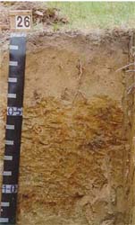 Plate9 - Map Units: Dgb, Dgc, Dgc - Brown Chromosol | 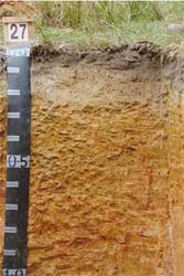 Plate 10 - Map Units: Dga, Dge - Brown Chromosol |
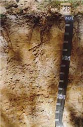 Plate 11 - Map Units: Dgf, Dgg - Grey Kurosol | 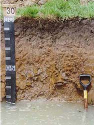 Plate 12 - Map Units: Dgh, Dgi - Grey Kurosol |
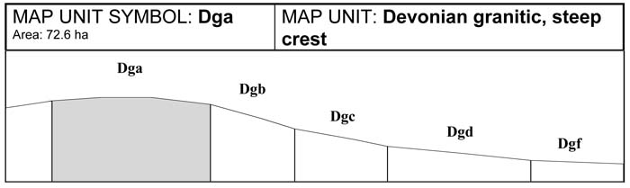
A. GENERAL DESCRIPTION
The soils of this unit are generally brown Chromosols and in some areas grey Tenosols. Outcropping granite tors are common and depth to hardrock is variable. Grey Tenosols are common where very shallow soils are present due to rock outcrop. These soils are generally dark brown sandy loams, or coarse sand and gravel, over sands. The brown Chromosol soils are more common with sandy loam topsoils over sandy to medium clay subsoils. These soils generally have bleached A2 horizons and mottled subsoils. Both soils sit on a weathered granitic rock that overlies hard rock. Nutrients are readily leached from these soils, leaving them generally infertile. If vegetation is removed these soils will erode.
SITE CHARACTERISTICS
| Parent Material Age: | Devonian | Depth to Seas. Watertable: | > 1.5 m | |
| Parent Material Lithology: | Granite/granodiorite | Flooding Risk: | Nil | |
| Landform Pattern: | Plateau/low hills | Drainage: | Moderately well drained | |
| Landform Element: | Hillcrest | Rock Outcrop: | 20-50% (Variable) | |
| Slope a) common: | 10% | Depth to Hard Rock: | > 1.5m | |
| Slope b) range: | 4-35% | |||
| Potential Recharge to Groundwater: | Low | |||
| Major Native Vegetation Species: | Messmate, Melaleuca | |||
| Present Land Use: | Recreational | |||
| Length of Growing Season: | 8 months | |||
LAND DEGRADATION
Degradation Processes | Water Erosion | Wind Erosion | Mass Movement | Salting | Acidification | |
sheet/rill | gully | |||||
Susceptibility | Moderate | Moderate | Moderate | Moderate | Low | Moderate |
Incidence | Low | Low | Low | Low | Low | NA |
B. SOIL PROFILE
PROFILE DESCRIPTION
| Site S27 | ||
A1 | 0-10 cm | Very dark greyish brown (10YR3/2) coarse sandy loam, weak subangular blocky structure, peds 10-20 mm, rough fabric, weak consistence, pH 5.5. Clear transition to: |
A2 | 10-25 cm | Light yellowish brown (10YR6/4) sandy clay loam, bleached (10YR8/3) when dry, massive structure, sandy fabric, very weak consistence, pH 5.3. Clear transition to: |
B2 | 25-60 cm | Yellowish brown (10YR5/6) light medium clay, coarse prominent orange and coarse faint red mottles are common, weak polyhedral structure, peds 50-100 mm, smooth fabric, firm consistence, pH 5.5. Diffuse transition to: |
C | 60-150+ cm | Weathered granite rock. |
Classification
| Factual Key: | Dy3.81 (major), Dy3.41 (minor) |
| Australian Soil Classification: | Bleached-Mottled, Magnesic, Brown Chromosol; medium, slightly gravelly, loamy/clayey, moderate (confidence level 2) |
| Unified Soil Group: | CH |
Interpretation of Laboratory Analysis*
Horizon | pH (CaCl2) | % Gravel | EC (salts) | Nutrient Status | P | K | Al | Organic Matter | Dispersibility |
A1 | 4.4** | 2% | VL | VL | D | S | T | H | VL |
A2 | 4.3** | 2% | VL | VL | D | D | S | VL | L |
B2 | 4.6 | < 1% | VL | L | D | D | S | VL | L |
T: Potentially Toxic NA: Not Available * see Appendix D for analytical results ** Strongly Acidic
Soil Profile Characteristics:
| Permeability: | Slow (estimate) |
| Available Water Capacity: | Low (80 mm H2O) |
| Linear Shrinkage (B horizon): | Moderate (15%) |
C. LAND CAPABILITY ASSESSMENT
Land Use | Class | Major Limiting Feature(s)/Land Use |
| Agriculture | C2T2S4 | Boulder content |
| Effluent Disposal (septic tanks) | 4-3 | Permeability |
| Farm Dams | 5 | Suitability of subsoil |
| Building Foundations slab stumps/footings | 4 4 | Proportion of boulders Proportion of boulders |
| Secondary Roads | 4 | Proportion of boulders |
| Rural Residential Development | 5 | Farm dams |
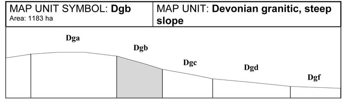
A. GENERAL DESCRIPTION
These steep slopes are generally found in association with steep crests (Dga). They are frequently dissected by minor drainage lines. These slopes often lead directly to drainage lines or moderately steep slopes. The major soil type is a brown Chromosol, with an occasional grey Tenosol present. The brown Chromosols have sandy loam topsoils over a sandy to medium clay. A bleached A2 horizon and mottled subsoils is common. Outcropping granite tors and rock restrict soil depth in many locations, the grey Tenosol is usually present under these circumstances. These soils are generally dark brown sandy loams, often coarse sand and gravel, over sands. Both soils sit on a decomposing sandy granite rock that overlies hard rock. Nutrients are readily leached from these soils making the soil relatively infertile. If vegetation is removed these soils are highly erodible and subject to sheet, rill and gully erosion. This unit is also subject to landslip.
SITE CHARACTERISTICS
| Parent Material Age: | Devonian | Depth to Seas. Watertable: | > 1.5 m | |
| Parent Material Lithology: | Granite/granodiorite | Flooding Risk: | Nil | |
| Landform Pattern: | Mountains/low hills | Drainage: | Well drained | |
| Landform Element: | Hillslope | Rock Outcrop: | < 50% | |
| Slope a) common: | 35 | Depth to Hard Rock: | 0.5-1.0m | |
| Slope b) range: | > 32% | |||
| Potential Recharge to Groundwater: | High | |||
| Major Native Vegetation Species: | Messmate, Narrow-leaved Peppermint, Hakea, Melaleuca | |||
| Present Land Use: | Recreational | |||
| Length of Growing Season: | 8 months | |||
LAND DEGRADATION
Degradation Processes | Water Erosion | Wind Erosion | Mass Movement | Salting | Acidification | |
sheet/rill | gully | |||||
Susceptibility | High | Moderate | Moderate | High | Low | Moderate |
Incidence | Moderate | Low | Low | Moderate | Low | NA |
B. SOIL PROFILE
PROFILE DESCRIPTION
| SITE S26 | ||
A1 | 0-10 cm | Dark greyish brown (10YR4/2) clayey coarse sand, weak subangular blocky structure, peds 10-20 mm, rough fabric, very weak consistence, pH 5.4. Clear transition to: |
A2 | 10-40 cm | Pale brown (10YR6/3) clayey coarse sand, bleached (10YR8/2) when dry, a few medium faint dark grey mottles, massive structure, weak consistence, a few small rounded granodiorite pebbles, pH 5.3. Clear transition to: |
B2 | 40-90 cm | Yellowish brown (10YR5/6) medium clay, very coarse prominent light brownish grey mottles are common, weak polyhedral structure, peds 50-100 mm, smooth fabric, very firm consistence, pH 6.0. Clear transition to: |
C | 90-150 cm | Weathered granodiorite. |
Classification
| Factual Key: | Dy3.81 (major), Dy3.41 (minor) |
| Australian Soil Classification: | Bleached-Mottled, Magnesic, Brown Chromosol; thick, non-gravelly, sandy/clayey, moderate (confidence level 2) |
| Unified Soil Group: | CH |
Interpretation of Laboratory ANAlysis*
Horizon | pH (CaCl2) | % Gravel | EC (salts) | Nutrient Status | P | K | Al | Organic Matter | Dispersibility |
A1 | 4.3** | < 1 | VL | VL | D | D | T | H | VL |
A2 | 4.4** | < 1 | VL | VL | D | D | S | VL | L |
B2 | 5.0 | < 1 | VL | L | D | D | S | VL | L |
T: Potentially Toxic NA: Not Available * see Appendix D for analytical results ** Strongly Acidic
Soil Profile Characteristics:
| Permeability: | Slow (average 35 mm/day, range 2-110 mm/day) |
| Available Water Capacity: | Moderate (130 mm H2O) |
| Linear Shrinkage (B horizon): | Moderate (15%) |
C. LAND CAPABILITY ASSESSMENT
| Land Use | Class | Major Limiting Feature(s)/Land Use |
| Agriculture | C2T5S4 | Slope |
| Effluent Disposal (septic tanks) | 5 | Slope |
| Farm Dams | 5 | Slope |
| Building Foundations slab stumps/footings | 5 4 | Slope Slope, proportion of stone and boulders, susceptibility to slope failure |
| Secondary Roads | 5 | Slope |
| Rural Residential Development | 5 | Secondary roads, farm dams, effluent disposal, building foundations (Slab) |
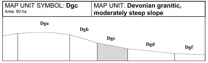
A. GENERAL DESCRIPTION
These moderately steep slopes are often seen in association with steep slopes (Dgb) and steep crests (Dga). They are highly dissected with minor drainage lines. These slopes often lead directly to drainage lines or moderate slopes. Outcropping granite rocks occur and depth to hardrock is variable. Where rock comes close to the surface, water from upslope may appear on the surface as a spring or minor depression. The implications for development where springs occur is that these areas are often waterlogged and drainage is impeded. Building upslope from these areas may cause problems with effluent disposal. Brown Chromosol soils with sandy loams over sandy to medium clays, commonly bleached A2 horizons and mottled subsoils are common. Minor grey Tenosols with dark brown sandy loams over sands may be present. These soils sit on decomposing granitic rock that overlies hard rock. Nutrients are readily leached from these soils making them relatively infertile. If vegetation is removed, these soils are highly erodible and subject to sheet, rill and gully erosion.
SITE CHARACTERISTICS
| Parent Material Age: | Devonian | Depth to Seas. Watertable: | > 1.5 m | |
| Parent Material Lithology: | Granite/granodiorite | Flooding Risk: | Nil | |
| Landform Pattern: | Low hills | Drainage: | Moderately well drained | |
| Landform Element: | Hillslope | Rock Outcrop: | < 10% | |
| Slope a) common: | 26% | Depth to Hard Rock: | 0.5-1.0 m | |
| Slope b) range: | 21-32% | |||
| Potential Recharge to Groundwater: | Moderate | |||
| Major Native Vegetation Species: | Messmate, Narrow-leaved Peppermint, Hakea, Melaleuca | |||
| Present Land Use: | Recreational | |||
| Length of Growing Season: | 8 months | |||
LAND DEGRADATION
Degradation Processes | Water Erosion | Wind Erosion | Mass Movement | Salting | Acidification | |
sheet/rill | gully | |||||
Susceptibility | Moderate | Moderate | Moderate | Moderate | Low | Moderate |
Incidence | Low | Low | Low | Low | Low | NA |
B. SOIL PROFILE
PROFILE DESCRIPTION
| Site S26 | ||
| A1 | 0-10 cm | Dark greyish brown (10YR4/2) clayey coarse sand, weak subangular blocky structure, peds 10-20 mm, rough fabric, very weak consistence, pH 5.4. Clear transition to: |
| A2 | 10-50 cm | Pale brown (10YR6/3) clayey coarse sand, bleached (10YR8/2) when dry, a few medium faint dark grey mottles, massive structure, weak consistence, a few small rounded granodiorite pebbles, pH 5.3. Clear transition to: |
| B2 | 50-90 cm | Yellowish brown (10YR5/6) medium clay, very coarse prominent light brownish grey mottles are common, weak polyhedral structure, peds 50-100 mm, smooth fabric, very firm consistence, pH 6.0. Clear transition to: |
| C | 90-150 cm | Weathered granodiorite. |
Classification
| Factual Key: | Dy3.41 (major), Dy3.81, Uc1.12 (minor) |
| Australian Soil Classification: | Bleached-Mottled, Magnesic, Brown Chromosol; thick, non-gravelly, sandy/clayey, moderate (confidence level 2) |
| Unified Soil Group: | CH |
Interpretation of Laboratory ANAlysis*
Horizon | pH (CaCl2) | % Gravel | EC (salts) | Nutrient Status | P | K | Al | Organic Matter | Dispersibility |
A1 | 4.3** | < 1 | VL | VL | D | D | S | M | VL |
A2 | 4.4** | < 1 | VL | VL | D | D | T | VL | L |
B2 | 5.0 | < 1 | VL | L | D | D | S | VL | L |
T: Potentially Toxic NA: Not Available * see Appendix D for analytical results ** Strongly Acidic
Soil Profile Characteristics:
| Permeability: | Slow (average 35 mm/day, range 2-110 mm/day) |
| Available Water Capacity: | Moderate (130 mm H2O) |
| Linear Shrinkage (B horizon): | Moderate (15%) |
C. LAND CAPABILITY ASSESSMENT
| Land Use | Class | Major Limiting Feature(s)/Land Use |
| Agriculture | C2T4S3 | Slope |
| Effluent Disposal (septic tanks) | 4 | Slope, slow permeability |
| Farm Dams | 5 | Slope |
| Building Foundations slab stumps/footings | 4 3 | Slope Slope, drainage, proportion of boulders, susceptibility to slope failure, linear shrinkage |
| Secondary Roads | 4 | Slope |
| Rural Residential Development | 5 | Farm dams |
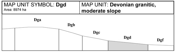
A. GENERAL DESCRIPTION
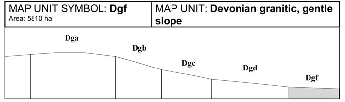
These moderate slopes are generally found in association with gentle slopes and gentle crests and may be dissected by minor drainage lines. Outcropping granite rocks are rare and depth to hardrock is variable. Where the rock comes close to the surface, water from upslope may appear on the surface as a spring and this has implications for development. These areas are often waterlogged and drainage is impeded. Building upslope from these areas may cause standard effluent disposal systems to fail. These soils are generally brown Chromosols with sandy loams over sandy to medium clays with bleached A2 horizons and mottled subsoils. In addition a grey Kurosol may occur. The grey Kurosol is a similar soil which is differentiated by the grey colour and increased depth. The soils sit on a decomposing sandy granitic rock that overlies hard rock. Nutrients are readily leached from these soils making them relatively infertile. If vegetation is removed these soils are subject to sheet, rill and gully erosion.
SITE CHARACTERISTICS
| Parent Material Age: | Devonian | Depth to Seas. Watertable: | > 1.5 m | |
| Parent Material Lithology: | Granite/granodiorite | Flooding Risk: | Nil | |
| Landform Pattern: | Low hills | Drainage: | Imperfectly drained | |
| Landform Element: | Hillslope | Rock Outcrop: | < 20% | |
| Slope a) common: | 15% | Depth to Hard Rock: | > 1.0 m | |
| Slope b) range: | 11-20% | |||
| Potential Recharge to Groundwater: | Moderate | |||
| Major Native Vegetation Species: | Messmate, Narrow-leaved Peppermint, Hakea, Melaleuca | |||
| Present Land Use: | Grazing | |||
| Length of Growing Season: | 8 months | |||
LAND DEGRADATION
Degradation Processes | Water Erosion | Wind Erosion | Mass Movement | Salting | Acidification | |
sheet/rill | gully | |||||
Susceptibility | Moderate | Moderate | Moderate | Moderate | Low | Moderate |
Incidence | Low | Low | Low | Low | Low | NA |
B. SOIL PROFILE
PROFILE DESCRIPTION
| Site S26 | ||
A1 | 0-10 cm | Dark greyish brown (10YR4/2) clayey coarse sand, weak subangular blocky structure, peds 10-20 mm, rough fabric, very weak consistence, pH 5.4. Clear transition to: |
A2 | 10-40 cm | Pale brown (10YR6/3) clayey coarse sand, bleached (10YR8/2) when dry, a few medium faint dark grey mottles, massive structure, weak consistence, a few small rounded granodiorite pebbles, pH 5.3. Clear transition to: |
B2 | 40-90 cm | Yellowish brown (10YR5/6) medium clay, very coarse prominent light brownish grey (10YR6/2) mottles are common, weak polyhedral structure, peds 50-100 mm, smooth fabric, very firm consistence, pH 6.0. Clear transition to: |
C | 90-150 cm | Weathered granodiorite |
Classification
| Factual Key: | Dy3.41(major), Dy3.81 (minor) |
| Australian Soil Classification: | Bleached-Mottled, Magnesic, Brown Chromosol; thick, non-gravelly, sandy/clayey, moderate (confidence level 2) |
| Unified Soil Group: | CH |
Interpretation of Laboratory ANAlysis*
Horizon | pH (CaCl2) | % Gravel | EC (salts) | Nutrient Status | P | K | Al | Organic Matter | Dispersibility |
A1 | 4.3** | < 1 | VL | VL | D | D | S | M | VL |
A2 | 4.4** | < 1 | VL | VL | D | D | T | VL | L |
B2 | 5.0 | < 1 | VL | L | D | D | S | VL | L |
T: Potentially Toxic NA: Not Available * see Appendix D for analytical results ** Strongly Acidic
Soil Profile Characteristics:
| Permeability: | Slow (average 35 mm/day, range 2-108 mm/day) |
| Available Water Capacity: | Moderate (130 mm/day) |
| Linear Shrinkage (B horizon): | Moderate (15%) |
C. LAND CAPABILITY ASSESSMENT
| Land Use | Class | Major Limiting Feature(s)/Land Use |
| Agriculture | C2T3S3 | Slope, topsoil condition, available water capacity, permeability-rainfall index, gravel stone and boulder content, susceptibility to sheet ,gully and wind erosion |
| Effluent Disposal (septic tanks) | 4 | Drainage, permeability |
| Farm Dams | 4 | Slope |
| Building Foundations slab stumps/footings | 4 4 | Slope, drainage Drainage |
| Secondary Roads | 4 | Slope, drainage |
| Rural Residential Development | 4 | Secondary roads, farm dams, effluent disposal, building foundations |
A. GENERAL DESCRIPTION
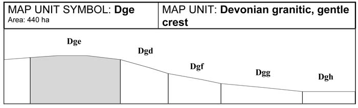
Outcropping granite tors may occur and depth to hardrock is variable on the gentle granitic crests. The soils are variable, however brown Chromosols are most common with the occassional Grey Kurosol on gentle side slopes. The brown Chromosols have sandy loams topsoils over sandy to medium clays with bleached A2 horizons and mottled sub soils. Nutrients are readily leached from these soils making them relatively infertile. Removal of vegetation may cause these soils to erode.
SITE CHARACTERISTICS
| Parent Material Age: | Devonian | Depth to Seas. Watertable: | > 1.5 m | |
| Parent Material Lithology: | Granite/granodiorite | Flooding Risk: | Nil | |
| Landform Pattern: | Plateau/low hills | Drainage: | Poorly drained | |
| Landform Element: | Hillcrest | Rock Outcrop: | 2-20 % (variable) | |
| Slope a) common: | 5% | Depth to Hard Rock: | 1.5m | |
| Slope b) range: | 0-10% | |||
| Potential Recharge to Groundwater: | Low | |||
| Major Native Vegetation Species: | Messmate, Narrow-leaved Peppermint, Hakea, Melaleuca | |||
| Present Land Use: | Grazing | |||
| Length of Growing Season: | 8 months | |||
LAND DEGRADATION
Degradation Processes | Water Erosion | Wind Erosion | Mass Movement | Salting | Acidification | |
sheet/rill | gully | |||||
Susceptibility | Low | Low | Moderate | Very low | Low | Moderate |
Incidence | Low | Low | Low | Very low | Low | NA |
B. SOIL PROFILE
PROFILE DESCRIPTION
| Site S27 | ||
A1 | 0-10 cm | Very dark grey brown (10YR3/2) coarse sandy loam, weak subangular blocky structure, peds 10-20 mm, rough fabric, weak consistence, pH 5.5. Clear transition to: |
A2 | 10-25 cm | Light yellowish brown (10YR6/4) sandy clay loam, bleached (10YR8/3) when dry, massive structure, sandy fabric, very weak consistence, pH 5.3. Clear transition to: |
B2 | 25-60 cm | Yellowish brown (10YR5/6) light medium clay, coarse prominent orange and coarse faint red mottles are common, weak polyhedral structure, peds 50-100 mm, smooth fabric, firm consistence, pH 5.5. Diffuse transition to: |
Bc | 60-150+ cm | Partially weathered granodiorite rock |
Classification
| Factual Key: | Dy3.81 (major), Dy3.41 (minor) |
| Australian Soil Classification: | Bleached-Mottled, Magnesic, Brown Chromosol; medium, slightly gravelly, loamy/clayey, moderate (confidence level 2) |
| Unified Soil Group: | CH |
Interpretation of Laboratory ANAlysis*
Horizon | pH (CaCl2) | % Gravel | EC (salts) | Nutrient Status | P | K | Al | Organic Matter | Dispersibility |
A1 | 4.4** | 2% | VL | VL | D | S | T | H | VL |
A2 | 4.3** | 2% | VL | VL | D | D | S | VL | L |
B2 | 4.6 | < 1% | VL | L | D | D | S | VL | L |
T: Potentially Toxic NA: Not Available * see Appendix D for analytical results ** Strongly Acidic
Soil Profile Characteristics:
| Permeability: | Very slow (average 2 mm/day, range 0-5 mm/day) |
| Available Water Capacity: | Low (80 mm H2O) |
| Linear Shrinkage (B horizon): | Moderate (15%) |
C. LAND CAPABILITY ASSESSMENT
| Land Use | Class | Major Limiting Feature(s)/Land Use |
| Agriculture | C2S2T4 | Permeability-rainfall index |
| Effluent Disposal (septic tanks) | 5 | Drainage, no. of months/year av. rainfall >Ksat, very slow permeability |
| Farm Dams | 5 | Suitability of subsoil |
| Building Foundations slab stumps/footings | 5 5 | Drainage Drainage |
| Secondary Roads | 5 | Drainage |
| Rural Residential Development | 5 | Secondary roads, farm dams, effluent disposal, building foundations |
A. GENERAL DESCRIPTION
This map unit is generally found on the elevated plateaux and undulating low foothills of the Tynong granite formation. This unit is often found in association with gentle crests (Dge) and drainage lines. The acidic grey Kurosol soils have sandy loam topsoils overlying sandy to medium clay subsoils. Bleached A2 horizons and mottled and sodic subsoils are common. Because of the lower position on the landscape, these soils are subject to waterlogging. These slopes may contain colluvial material where they adjoin steep slopes. These leached colluvial soils are also acidic.
SITE CHARACTERISTICS
| Parent Material Age: | Devonian | Depth to Seas. Watertable: | > 1.0m | |
| Parent Material Lithology: | Granite/granodiorite | Flooding Risk: | Nil | |
| Landform Pattern: | Low hills | Drainage: | Imperfectly drained | |
| Landform Element: | Footslope | Rock Outcrop: | < 5% | |
| Slope a) common: | 8% | Depth to Hard Rock: | > 1.5 m | |
| Slope b) range: | 4-10% | |||
| Potential Recharge to Groundwater: | Low | |||
| Major Native Vegetation Species: | Messmate, Narrow-leaved Peppermint, Hakea, Melaleuca | |||
| Present Land Use: | Grazing | |||
| Length of Growing Season: | 8 months | |||
LAND DEGRADATION
Degradation Processes | Water Erosion | Wind Erosion | Mass Movement | Salting | Acidification | |
sheet/rill | gully | |||||
Susceptibility | Low | Low | Low | Very low | Low | Moderate |
Incidence | Low | Low | Low | Very low | Low | NA |
B. SOIL PROFILE
PROFILE DESCRIPTION
| Site S28 | ||
A11 | 0-5 cm | Dark grey (10YR4/1) humic coarse sandy loam, weak subangular blocky structure, peds 2-5 mm, smooth fabric, very weak consistence, pH 4.8. Abrupt transition to: |
A12 | 5-20 cm | Greyish brown (10YR5/2) light coarse sandy loam, massive structure, sandy fabric, very weak consistence, pH 5.1. Clear transition to: |
A2 | 20-40 cm | Pale brown (10YR6/3) heavy coarse sandy loam, bleached (10YR7/3) when dry, a few medium faint yellowish brown mottles, massive structure, sandy fabric, weak consistence, pH 5.6. Gradual transition to: |
B1 | 40-60 cm | Light brownish grey (10YR6/2) coarse sandy clay, many coarse distinct yellowish brown mottles, weak subangular blocky structure, peds 20-50 mm, rough fabric, weak consistence. Clear transition to: |
B2 | 60-85 cm | Light grey (10YR6/1) medium clay, many very coarse prominent yellowish brown (10YR5/8) mottles, weak subangular blocky structure, peds 20-50 mm, smooth fabric, very firm consistence, pH 5.5. Diffuse transition to: |
C | 85-150+ cm | Weathered granodiorite rock. |
Classification
| Factual Key: | Dy3.41 (major), Dy3.81 (minor) |
| Australian Soil Classification: | Bleached-Sodic, Magnesic-Natric, Grey KUROSOL; thick, non-gravelly, loamy/clayey, moderate (confidence level 2) |
| Unified Soil Group: | CH |
Interpretation of Laboratory ANAlysis*
Horizon | pH (CaCl2) | % Gravel | EC (salts) | Nutrient Status | P | K | Al | Organic Matter | Dispersibility |
A11 | 3.9** | < 1 | VL | VL | D | D | T | H | VL |
A12 | 4.2** | < 1 | VL | VL | D | D | S | VL | L |
A2 | 4.2** | < 1 | VL | VL | D | D | T | VL | L |
B2 | 4.2** | 0 | VL | L | D | D | T | VL | L |
T: Potentially Toxic NA: Not Available * see Appendix D for analytical results ** Strongly Acidic
Soil Profile Characteristics:
| Permeability: | Slow (average 35 mm/day, range 0-80 mm/day) |
| Available Water Capacity: | Low-Moderate (100 mm H2O) |
| Linear Shrinkage (B horizon): | Moderate (13.5%) |
C. LAND CAPABILITY ASSESSMENT
| Land Use | Class | Major Limiting Feature(s)/Land Use |
| Agriculture | C2T2S4 | Topsoil conditions (A12) |
| Effluent Disposal (septic tanks) | 4 | Drainage, slow permeability |
| Farm Dams | 3 | Slope, linear shrinkage, suitability of subsoil, depth to seasonal watertable, depth to hardrock, permeability, low dispersibility of subsoil |
| Building Foundations slab stumps/footings | 4 4 | Drainage Drainage |
| Secondary Roads | 4 | Drainage |
| Rural Residential Development | 4 | Secondary roads, effluent disposal, building foundations |
A. GENERAL DESCRIPTION
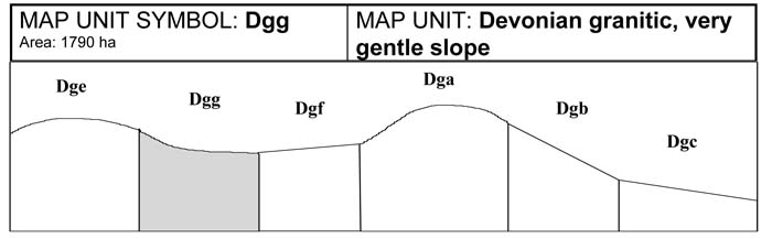
This map unit is generally found on the elevated plateaux and low undulating foothills. This unit often occurs in association with gentle crests (Dge), gentle slopes (Dgf) and drainage lines (Dgh). The soils are commonly grey Kurosols with sandy loams over sandy to medium clays. These slopes may contain colluvial material where they adjoin steep slopes. The colluvial wash over these soils is highly leached and the topsoils on this unit are generally acidic. These soils have bleached A2 horizons, with mottled and sodic subsoils. Because of the gentle slopes this unit is subject to waterlogging. Many springs occur and may be associated with minor salting. The presence of tussock grass and swamp paperbark are good indicators of the presence of waterlogging or a spring.
SITE CHARACTERISTICS
| Parent Material Age: | Devonian | Depth to Seas. Watertable: | 1.0 m | |
| Parent Material Lithology: | Granite/granodiorite | Flooding Risk: | Nil | |
| Landform Pattern: | Low hills | Drainage: | Imperfectly drained | |
| Landform Element: | Footslope | Rock Outcrop: | < 5% | |
| Slope a) common: | 2% | Depth to Hard Rock: | > 1.5 m | |
| Slope b) range: | 1-3% | |||
| Potential Recharge to Groundwater: | ||||
| Major Native Vegetation Species: | Messmate, Narrow-leaved Peppermint, Hakea, Melaleuca | |||
| Present Land Use: | Grazing | |||
| Length of Growing Season: | 8 months | |||
LAND DEGRADATION
Degradation Processes | Water Erosion | Wind Erosion | Mass Movement | Salting | Acidification | |
sheet/rill | gully | |||||
Susceptibility | Very low | Very low | Low | Very low | Moderate | Moderate |
Incidence | Low | Low | Low | Very low | Low | NA |
B. SOIL PROFILE
PROFILE DESCRIPTION
| Site S28 | ||
A11 | 0-5 cm | Dark grey (10YR4/1) humic coarse sandy loam, weak subangular blocky structure, peds 2-5 mm, smooth fabric, very weak consistence, pH 4.8. Abrupt transition to: |
A12 | 5-20 cm | Greyish brown (10YR5/2) light coarse sandy loam, massive structure, sandy fabric, very weak consistence, pH 5.1. Clear transition to: |
A2 | 20-40 cm | Pale brown (10YR6/3) coarse sandy loam, bleached (10YR7/3) when dry, a few medium faint yellowish brown (10YR5/8) mottles, massive structure, sandy fabric, weak consistence, pH 5.6. Gradual transition to: |
B1 | 40-60 cm | Light brownish grey (10YR6/2), coarse sandy clay, many coarse distinct yellowish brown mottles, weak subangular blocky structure, peds 20-50 mm, rough fabric, weak consistence. Clear transition to: |
B2 | 60-85 cm | Light grey (10YR6/1) medium clay, many very coarse prominent yellowish brown mottles, weak subangular blocky structure, peds 20-50 mm, smooth fabric, very firm consistence, pH 5.5. Diffuse transition to: |
C | 85-150 cm | Weathered granodiorite rock. |
Classification
| Factual Key: | Dy3.41 |
| Australian Soil Classification: | Bleached-Sodic, Magnesic-Natric, Grey KUROSOL; thick, non-gravelly, loamy/clayey, moderate (confidence level 2) |
| Unified Soil Group: | CH |
Interpretation of Laboratory ANAlysis*
Horizon | pH (CaCl2) | % Gravel | EC (salts) | Nutrient Status | P | K | Al | Organic Matter | Dispersibility |
A11 | 3.9** | < 1 | VL | VL | D | D | T | H | VL |
A12 | 4.2** | < 1 | VL | VL | D | D | T | VL | L |
A2 | 4.2** | < 1 | VL | VL | D | D | T | VL | L |
B2 | 4.2** | 0 | VL | L | D | D | T | VL | L |
T: Potentially Toxic NA: Not Available * see Appendix D for analytical results ** Strongly Acidic
Soil Profile Characteristics:
| Permeability: | Slow (average 35 mm/day, range 0-80 mm/day) |
| Available Water Capacity: | Low-Moderate (100 mm H2O) |
| Linear Shrinkage (B horizon): | Moderate (13.5%) |
C. LAND CAPABILITY ASSESSMENT
| Land Use | Class | Major Limiting Feature(s)/Land Use |
| Agriculture | C2T1S4 | Conditions of topsoil (A12) |
| Effluent Disposal (septic tanks) | 4 | Drainage, slow permeability |
| Farm Dams | 3 | Linear shrinkage, suitability of subsoil, depth to seasonal watertable, depth to hardrock, permeability, low dispersibility of subsoil |
| Building Foundations slab stumps/footings | 4 4 | Drainage Drainage |
| Secondary Roads | 4 | Drainage |
| Rural Residential Development | 4 | Secondary roads, effluent disposal, building foundations |
A. GENERAL DESCRIPTION
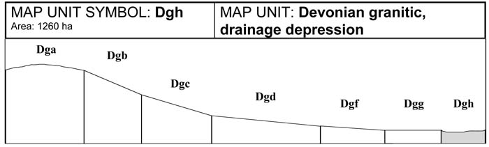
Drainage depressions vary from broad open drainage depressions in the valleys, to narrow drainage corridors that connect major drainage lines and incipient floodplains at low elevations. Grey Kurosols with clay subsoils are common in the lower and more defined drainage lines. A buried, uniform coarse sandy soil is often found at depth. The leached topsoils are acidic and contain high amounts of coarse sand and gravel. These soils are prone to waterlogging in winter and spring, especially where drainage depressions occur in broad flat valleys. The occurrence of tussock grass and swamp paperbark may indicate the presence of waterlogging. In winter months, drainage depressions at low elevation, may have high seasonal watertables and surface ponding.
SITE CHARACTERISTICS
| Parent Material Age: | Devonian | Depth to Seas. Watertable: | 0.5-1.0 m | |
| Parent Material Lithology: | granite/granodiorite | Flooding Risk: | Moderate | |
| Landform Pattern: | Undulating Hills | Drainage: | Imperfectly drained | |
| Landform Element: | Drainage depression | Rock Outcrop: | Nil | |
| Slope a) common: | 3% | Depth to Hard Rock: | > 1.7 m | |
| Slope b) range: | 1-15% | |||
| Potential Recharge to Groundwater: | Low | |||
| Major Native Vegetation Species: | Messmate, Narrow-leaved Peppermint, Hakea, Melaleuca | |||
| Present Land Use: | Grazing | |||
| Length of Growing Season: | 8 months | |||
LAND DEGRADATION
Degradation Processes | Water Erosion | Wind Erosion | Mass Movement | Salting | Acidification | |
sheet/rill | gully | |||||
Susceptibility | Low | Low | Low | Very low | Low | Moderate |
Incidence | Low | Moderate | Low | Very low | Low | NA |
B. SOIL PROFILE
PROFILE DESCRIPTION
| Site S30 | ||
A1 | 0-15 cm | Dark grey (10YR4/1) loam, moderate subangular blocky structure, peds 20-50 mm, rough fabric, weak consistence, pH 4.9. Abrupt transition to: |
A21 | 15-30 cm | Greyish brown (10YR5/2) silty loam, bleached (10YR8/1) when dry, massive structure, earthy fabric, weak consistence, pH 5.0. Gradual transition to: |
A22 | 30-50 cm | Dark yellowish brown (10YR6/3) coarse sandy loam, bleached (10YR8/1) when dry, many coarse distinct orange mottles and coarse faint brown mottles, massive structure, earthy fabric, very weak consistence, pH 5.0. Clear transition to: |
B2 | 50-85 cm | Grey (7.5YR6/0) medium clay, many coarse distinct orange mottles and coarse faint brown mottles, moderate polyhedral and angular blocky structure, peds 5-10 mm, smooth fabric, plastic consistence, few small subrounded pebbles, pH 5.0. Gradual transition to: |
C | 85-150 cm | Partially weathered granodiorite. |
Classification
| Factual Key: | Dy3.41 (major), Dy3.81 (minor) |
| Australian Soil Classification: | Bleached-Mottled, Mesotrophic, Grey KUROSOL; thick, non-gravelly, loamy/clayey, moderate (confidence level 2) |
| Unified Soil Group: | CH |
Interpretation of Laboratory ANAlysis*
Horizon | pH (CaCl2) | % Gravel | EC (salts) | Nutrient Status | P | K | Al | Organic Matter | Dispersibility |
A1 | 4.0** | 0 | VL | VL | S | D | T | H | L |
A21 | 4.1** | 0 | VL | VL | S | D | S | M | M |
A22 | 4.1** | 0 | VL | VL | D | D | T | VL | M |
B2 | 4.0** | 0 | VL | VL | D | D | T | L | VL |
T: Potentially Toxic NA: Not Available * see Appendix D for analytical results ** Strongly Acidic
Soil Profile Characteristics:
| Permeability: | Very slow (0-10 mm/day (estimate)) |
| Available Water Capacity: | Moderate (120 mm H2O) |
| Linear Shrinkage (B horizon): | Moderate (15%) |
C. LAND CAPABILITY ASSESSMENT
| Land Use | Class | Major Limiting Feature(s)/Land Use |
| Agriculture | C2T2S5 | Depth to seasonal watertable |
| Effluent Disposal (septic tanks) | 5 | No. of months/year av. rainfall >Ksat, very slow permeability |
| Farm Dams | 5 | Depth to seasonal watertable, dispersibility of subsoil |
| Building Foundations slab stumps/footings | 4 4 | Drainage, depth to seasonal watertable Drainage, depth to seasonal watertable |
| Secondary Roads | 4 | Drainage, depth to seasonal watertable |
| Rural Residential Development | 5 | Farm dams, effluent disposal |
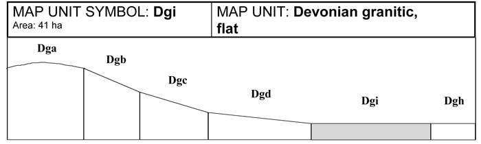
A. GENERAL DESCRIPTION
The flats are associated with the lower slopes and drainage lines of the granitic terrain. Acidic, grey Kurosols are common with light topsoils and clay subsoils. These soils generally have bleached A2 horizons and strongly mottled subsoils. Buried, uniform coarse sandy soil may be found at depth. Colluvial material from adjoining slopes and alluvial wash from past flooding events has contributed to the formation of this soil. Topsoils influenced by alluvial deposition contain higher amounts of coarse sand and gravel. These soils are prone to waterlogging in winter and spring months, especially close to the drainage depressions where the occurrence of tussock grass and swamp paperbark indicates the presence of waterlogging.
SITE CHARACTERISTICS
| Parent Material Age: | Devonian | Depth to Seas. Watertable: | 0.5-1 m | |
| Parent Material Lithology: | Granite/granodiorite | Flooding Risk: | Moderate | |
| Landform Pattern: | Plateau/low hills | Drainage: | Imperfectly drained | |
| Landform Element: | Valley flat | Rock Outcrop: | Nil | |
| Slope a) common: | 1% | Depth to Hard Rock: | > 1.7 m | |
| Slope b) range: | 0-2 | |||
| Potential Recharge to Groundwater: | Low | |||
| Major Native Vegetation Species: | Melaleuca, Messmate | |||
| Present Land Use: | Grazing | |||
| Length of Growing Season: | 8 months | |||
LAND DEGRADATION
Degradation Processes | Water Erosion | Wind Erosion | Mass Movement | Salting | Acidification | |
sheet/rill | gully | |||||
Susceptibility | Low | Low | Low | Very low | Moderate | Moderate |
Incidence | Low | Low | Low | Very low | Low | NA |
B. SOIL PROFILE
PROFILE DESCRIPTION
| Site S30 | ||
| A1 | 0-15 cm | Dark grey (10YR4/1) loam, moderate subangular blocky structure, peds 20-50 mm, rough fabric, weak consistence, pH 4.9. Abrupt transition to: |
| A21 | 15-30 cm | Greyish brown (10YR5/2) silty loam, bleached (10YR8/1) when dry, massive structure, earthy fabric, weak consistence, pH 5.0. Gradual transition to: |
| A22 | 30-50 cm | Dark yellowish brown (10YR6/3) coarse sandy loam, bleached (10YR8/1) when dry, many coarse distinct orange mottles and coarse faint brown mottles, massive structure, earthy fabric, very weak consistence, pH 5.0. Clear transition to: |
| B2 | 50-85 cm | Grey (7.5YR6/0) medium clay, many coarse distinct orange mottles and coarse faint brown mottles, moderate polyhedral and angular blocky structure, peds 5-10 mm, smooth fabric, plastic consistence, few small subrounded pebbles, pH 5.0. Gradual transition to: |
| BC | 85-150 cm | Partially weathered granodiorite. |
Classification
| Factual Key: | Dy3.41 (major), Dy3.81 (minor) |
| Australian Soil Classification: | Bleached-Mottled, Mesotrophic, Grey KUROSOL; thick, non-gravelly, loamy/clayey, moderate (confidence level 2) |
| Unified Soil Group: | CH |
Interpretation of Laboratory ANAlysis*
Horizon | pH (CaCl2) | % Gravel | EC (salts) | Nutrient Status | P | K | Al | Organic Matter | Dispersibility |
A1 | 4.0** | 0 | VL | VL | S | D | T | H | L |
A21 | 4.1** | 0 | VL | VL | S | D | T | M | M |
A22 | 4.1** | 0 | VL | VL | D | D | T | VL | M |
B2 | 4.0** | 0 | VL | VL | D | D | T | L | VL |
T: Potentially Toxic NA: Not Available * see Appendix D for analytical results ** Strongly Acidic
Soil Profile Characteristics:
| Permeability: | Very slow (0-10 mm/day (estimate)) |
| Available Water Capacity: | Moderate (120 mm H2O) |
| Linear Shrinkage (B horizon): | Moderate (15%) |
C. LAND CAPABILITY ASSESSMENT
| Land Use | Class | Major Limiting Feature(s)/Land Use |
| Agriculture | C2T1S5 | Depth to seasonal watertable |
| Effluent Disposal (septic tanks) | 5 | No. of months/year av. rainfall > Ksat, permeability |
| Farm Dams | 5 | Depth to seasonal watertable, very low dispersibility of subsoil |
| Building Foundations slab stumps/footings | 4 4 | Drainage, depth to seasonal watertable Drainage, depth to seasonal watertable |
| Secondary Roads | 4 | Drainage, depth to seasonal watertable |
| Rural Residential Development | 5 | Farm dams, effluent disposal |

© State of Victoria (Agriculture Victoria) 1996 - .

This work, Victorian Resources Online, is licensed under a Creative Commons Attribution 4.0 licence. You are free to re-use the work under that licence, on the condition that you credit the State of Victoria (Agriculture Victoria) as author, indicate if changes were made and comply with the other licence terms.
The licence does not apply to ‘branding’ or some ‘images or photographs’ that may be owned by third parties. We ask you to seek prior approval to use images using the VRO feedback form. Access to higher quality images can also be provided on request.
This page was last updated on .