
LCA Cardinia Shire - Tech Report No. 29 - Chapter 4.3
Tsd | Tse | Tsf | Tsg | Tsh
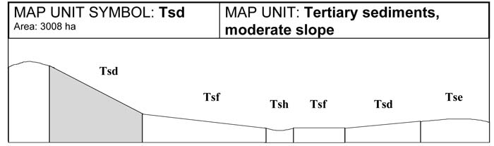
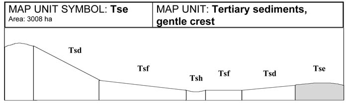
4.3 Tertiary sedimentary map units (Ts)
In the south west of the Shire, close to the areas of Lang Lang, Heath Hill and Nyora, a small area of tertiary sedimentary terrain exits. This area is part of the widespread sheet of Upper Miocene sandy fluviatile beds (floodplain), and was termed Baxter Sandstone (Keble, Jenkins and Thompson 1950, as cited by Rosengren, 1984, and Jenkins 1962, 1974). It was noted by Thompson (1974), that this material also contained large amounts of silts and clays as well as sands, and therefore proposed the term Baxter Formation in preference to the term Baxter Sandstone (Rosengren 1984). These sediments have been subject to warping rather than strong faulting and folding.
These Tertiary sediments contain ferruginous gravel and weakly cemented sandy clays and clays. At depth there may be iron cemented sandstone and some build up of ironstone nodules between the A and B horizons. These clays are mottled, and may show distinctive red mottling at depth. Much of the Tertiary deposits have been covered by more recent Quaternary clays and sands.
The terrain in this area is best described as low rolling hills or undulating low hills.
Grazing has taken place since early European settlement. Loss of vegetation cover through clearing, combined with periods of cultivation and over grazing, have modified the soils present. In many cases, erosion has removed much of the original topsoil, while cultivation has resulted in mixing of topsoil and subsoil. Many soil types present are considered to be modified soils and are likely to differ from undisturbed soils in their natural state.
Soils vary due to changes in land use, topography and climate. Gentle crests show greater soil depth than steep crests and slopes. The latter being subjected to continuous soil erosion. Lower slopes are subject to less erosion as well as a build up of colluvial material leading to deeper soils. Flatter areas and drainage depressions are subject to alluvial deposition. The topsoils in these alluvial areas often have high concentrations of sand. Soil depth in drainage lines regularly exceeds 2.0 metres in depth. Soils present on gentle crests are mostly Sodosols. Mottled yellow Dermosols with bleached A2 horizons and sodic subsoils dominate the gentle slopes and broad drainage depressions of the low, undulating hills.
Bleached A2 horizons are common. These bleached A2 horizons have high percentages of silt and fine sand. Because of this, the A2 horizons have a low liquid limit. When excess water is added these soils, the A2 horizons become sloppy and have little cohesive strength. The A2 horizon is susceptible to sheet erosion if exposed by the removal of vegetation and topsoil.
In some areas, excluding the flats and drainage depressions, a layer of stone and gravel may exist in the A2 horizon, or at the top of the B horizon. These sedimentary stones appear as discreet layers and are generally subangular to angular ranging in size from 20-200 mm in diameter. These stones can account for up to 40 per cent of the volume of the horizon. Rocks do not commonly occur on the surface or within the B horizons.
Various land degradation problems exist within the Tertiary landscape. In the steeper terrain, some sheet and gully erosion occur where vegetation cover is sparse. The sodic subsoils present in the low undulating terrain have contributed to gully and stream bank erosion. Waterlogging is common along drainage lines and below leaking dams. In these situations, spiny rush is a good indicator of waterlogging and possible salinity.
Land management considerations
The major land management concerns include low subsoil permeability and moderate to high dispersibility of the subsoil, particularly on the lower slopes and depressions. Shallow depth to hard rock may be a problem on crests.
With rural residential development increasing in these areas, careful design of effluent disposal fields, farm dams and secondary roading is required. Consideration must also be given to dam construction and the impact upon environmental streamflows.
In some areas within this unit, there may be an accumulation of sandy material in the topsoil. Where free draining topsoil overlies a sandy to medium clay, it creates favourable growing conditions for horticultural crops. These areas are limited in size as the build up of sand is not common. The sand build-up may be from aeolian sources or recent alluvium.
Grazing is more common in this area with few limitations except for pugging of the soil which may occur with overstocking in winter months.
Soils of Tertiary Sedimentary origin
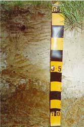 Plate 7 - Map Units: Tsd, Tsf - Brown Dermosol | 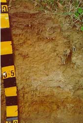 Plate 8 - Map Unit: Tse, Brown Sodosol |
A. GENERAL DESCRIPTION
These moderate slopes are found throughout this sedimentary area. Soils have increased depth where material accumulates close to the drainage line or break of slope. The dominant soil type is a mottled yellow Dermosol with a bleached A2 horizon and a sodic subsoil. A rock layer is common in the A2 horizon or on top of the B1 horizon. The sandy or silty A2 horizon has a very weak structure that breaks down readily when excess water is added.
SITE CHARACTERISTICS
| Parent Material Age: | Tertiary | Depth to Seas. Watertable: | > 1.5 m | |
| Parent Material Lithology: | Sediments | Flooding Risk: | Nil | |
| Landform Pattern: | Rolling hills | Drainage: | Well drained | |
| Landform Element: | Hillslope | Rock Outcrop: | < 10% | |
| Slope a) common: | 16% | Depth to Hard Rock: | > 1.5 m | |
| Slope b) range: | 11-20% | |||
| Potential Recharge to Groundwater: | Low | |||
| Major Native Vegetation Species: | Narrow-leaved Peppermint , Messmate, Melaleuca | |||
| Present Land Use: | Grazing | |||
| Length of Growing Season: | 8 months | |||
LAND DEGRADATION
Degradation Processes | Water Erosion | Wind Erosion | Mass Movement | Salting | Acidification | |
sheet/rill | gully | |||||
Susceptibility | Low | Low | Very low | Moderate | Low | Moderate |
Incidence | Low | Low | Very low | Low | Low | NA |
B. SOIL PROFILE
PROFILE DESCRIPTION
| Site C2 | ||
A1 | 0-15 cm | Very dark greyish brown (10YR3/2) clay loam (fine sandy), moderate subangular blocky structure, peds 10-20 mm, rough fabric, weak consistence, pH 5.9. Clear transition to: |
A21 | 15-30 cm | Brown (10YR5/3) fine sandy clay loam, bleached (10YR7/2) when dry, weak subangular blocky structure, rough fabric, peds 10-20 mm, weak consistence, pH 5.8. Clear transition to: |
A22 | 30-45 cm | Yellowish brown (2.5Y6/3) fine sandy clay, massive structure, earthy fabric, firm consistence, a few medium subrounded sedimentary pebbles. Clear transition to: |
B1 | 45-55 cm | Brownish yellow (10YR6/6) light clay, medium distinct yellowish orange mottles are common, weak subangular blocky structure, peds 20-50 mm, rough fabric, firm consistence. Clear transition to: |
B21 | 55-90 cm | Yellowish brown (10YR5/6) heavy clay (with coarse sand), many coarse prominent yellowish orange mottles, strong subangular blocky structure, smooth fabric, peds 10-20 mm, weak consistence, pH 5.5. Clear transition to: |
B22 | 90-150 cm | Yellowish brown (10YR5/6) heavy clay, many very coarse prominent yellowish orange mottles, strong subangular blocky structure, smooth fabric, peds 20-50 mm, weak consistence, pH 5.4. |
Classification
| Factual Key: | Gn3.84 |
| Australian Soil Classification: | Bleached-Sodic, Eutrophic, Brown DERMOSOL; medium, slightly gravelly, clay loamy/clayey, very deep (confidence level 2) |
| Unified Soil Group: | CH |
Interpretation of Laboratory ANAlysis*
Horizon | pH (CaCl2) | % Gravel | EC (salts) | Nutrient Status | P | K | Al | Organic Matter | Dispersibility |
A1 | 4.8 | 7 | VL | VL | D | D | S | H | VL |
A21 | 4.6 | 10 | VL | L | D | D | T | L | VL |
A22 | NA | 15 | NA | NA | NA | NA | NA | NA | M |
B1 | NA | 20 | NA | NA | NA | NA | NA | NA | M |
B21 | 4.5 | 25 | VL | L | D | D | S | VL | L |
B22 | 4.7 | 25 | VL | M | D | S | S | VL | L |
T: Potentially Toxic NA: Not Available * see Appendix D for analytical results ** Strongly Acidic
Soil Profile Characteristics:
| Permeability: | Moderate (average 155 mm/day, range 90-300 mm/day) |
| Available Water Capacity: | Very high (220 mm H2O) |
| Linear Shrinkage (B horizon): | Moderate (17%) |
C. LAND CAPABILITY ASSESSMENT
Land Use | Class | Major Limiting Feature(s)/Land Use |
| Agriculture | C2T3S3 | Slope, gravel and stone content |
| Effluent Disposal (septic tanks) | 3 | Slope |
| Farm Dams | 4 | Slope, permeability |
| Building Foundations slab stumps/footings | 4 3 | Slope Slope, proportion of stones, susceptibility to slope failure, linear shrinkage |
| Secondary Roads | 4 | Slope |
| Rural Residential Development | 4 | Farm dams, building foundations (slab), secondary roads |
A. GENERAL DESCRIPTION
Gentle crests are common in this area. Soil depth varies between 1.0 to 1.5 metres with few surface rocks. Mottled brown Sododol soils are dominant and may contain a distinct bleached A2 horizon. Soils may have a stone layer in the A2 horizon at about 25-30 cm in depth. The bleached A2 horizons have poor structure and are prone to erosion if exposed, but in general, erosion risk is low because of the gentle slope.
SITE CHARACTERISTICS
| Parent Material Age: | Tertiary | Depth to Seas. Watertable: | > 1.5 m | |
| Parent Material Lithology: | Sediments | Flooding Risk: | Nil | |
| Landform Pattern: | Low hills | Drainage: | Well drained | |
| Landform Element: | Crest | Rock Outcrop: | < 10% | |
| Slope a) common: | 4% | Depth to Hard Rock: | 1.5m (variable) | |
| Slope b) range: | 2-7% | |||
| Potential Recharge to Groundwater: | Low | |||
| Major Native Vegetation Species: | Messmate, Narrow-leaved Peppermint | |||
| Present Land Use: | Grazing | |||
| Length of Growing Season: | 8 months | |||
LAND DEGRADATION
Degradation Processes | Water Erosion | Wind Erosion | Mass Movement | Salting | Acidification | |
sheet/rill | gully | |||||
Susceptibility | Low | Low | Very low | Low | Very low | Moderate |
Incidence | Low | Low | Very low | Very low | Very low | NA |
B. SOIL PROFILE
PROFILE DESCRIPTION
| Site C4 | ||
A1 | 0-15 cm | Very dark greyish brown (10YR3/2) sandy clay loam, moderate prismatic structure, peds 10-20 mm, rough fabric, firm consistence, pH 6.1. Clear transition to: |
A2 | 15-55 cm | Brown (7.5YR5/4) fine sandy loam, bleached (7.5YR7/2) when dry, weak subangular blocky structure, peds 5-10 mm, rough fabric, weak consistence, pH 5.2. Clear transition to: |
B1 | 55-70 cm | Yellowish brown (10YR5/4) light clay (with fine sand), weak subangular blocky structure, peds 20-50 mm, rough fabric, firm consistence, small subrounded sedimentary pebbles are common, pH 6.0. Clear transition to: |
B21 | 70-85 cm | Dark yellowish brown (10YR4/6) medium heavy clay, coarse faint red mottles are common, moderate subangular blocky to prismatic structure, peds 5-10 mm, rough fabric, a few small subrounded sedimentary (ironstone) pebbles, pH 6.0. Clear transition to: |
B22 | 85-100+ cm | Dark yellowish brown (10YR4/6) medium heavy clay, coarse faint red mottles are common, strong prismatic structure, peds 5-10 mm, smooth fabric, firm consistence, pH 6.0. |
Classification
| Factual Key: | Dy3.41 |
| Australian Soil Classification: | Eutrophic, Mottled-Hypernatric, Brown SODOSOL; thick slightly gravelly, clay loamy/clayey, very deep (confidence level 2) |
| Unified Soil Group: | CL |
Interpretation of Laboratory ANAlysis*
Horizon | pH (CaCl2) | % Gravel | EC (salts) | Nutrient Status | P | K | Al | Organic Matter | Dispersibility |
A1 | 5.1 | 5 | VL | M | D | S | S | H | L |
A2 | 4.6 | 0 | VL | VL | D | S | T | VL | L |
B1 | NA | 40 | NA | NA | NA | NA | NA | NA | M-H |
B21 | 4.9 | 35 | VL | VL | D | D | S | VL | M-H |
B22 | NA | 20 | NA | NA | NA | NA | NA | NA | L |
T: Potentially Toxic NA: Not Available * see Appendix D for analytical results ** Strongly Acidic
Soil Profile Characteristics:
| Permeability: | Moderate (average 130 mm/day, range 15-260 mm/day) |
| Available Water Capacity: | High (180 mm H20) |
| Linear Shrinkage (B horizon): | Low (9%) |
C. LAND CAPABILITY ASSESSMENT
Land Use | Class | Major Limiting Feature(s)/Land Use |
| Agriculture | C2T2S3 | Gravel and stone content |
| Effluent Disposal (septic tanks) | 2 | Nil |
| Farm Dams | 4 | Permeability, depth to hardrock (variable) |
| Building Foundations slab stumps/footings | 3 3 | Proportion of stone and gravel Proportion of stone and gravel |
| Secondary Roads | 3 | Proportion of stone and gravel, dispersibility of subsoil, USG subsoil |
| Rural Residential Development | 4 | Farm dams |
A. GENERAL DESCRIPTION
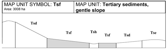
Gentle slopes are common throughout this sedimentary terrain. The dominant soil type is a mottled, yellow Dermosol with a bleached A2 horizon and sodic subsoil. The A horizons range from sandy loams to fine sandy clay loams. A2 horizons may contain more sand and silt making them sloppy when saturated. This horizon may erode if exposed. Some horizons may contain high concentrations of quartz sand. The B horizons range from light medium to heavy clays and are strongly mottled and sodic. The sodic nature of the subsoil makes this unit susceptible to water erosion. Grazing is the most common land use on this unit.
SITE CHARACTERISTICS
| Parent Material Age: | Tertiary | Depth to Seas. Watertable: | > 1.5 m | |
| Parent Material Lithology: | Sediments | Flooding Risk: | Very low | |
| Landform Pattern: | Low hills | Drainage: | Imperfectly drained | |
| Landform Element: | Gentle slope | Rock Outcrop: | < 2% | |
| Slope a) common: | 7% | Depth to Hard Rock: | > 1.5 m | |
| Slope b) range: | 4-10% | |||
| Potential Recharge to Groundwater: | Low | |||
| Major Native Vegetation Species: | Messmate, Melaleuca | |||
| Present Land Use: | Grazing (major), Horticulture (minor) | |||
| Length of Growing Season: | 8 months | |||
LAND DEGRADATION
Degradation Processes | Water Erosion | Wind Erosion | Mass Movement | Salting | Acidification | |
sheet/rill | gully | |||||
Susceptibility | Low | Low | Very low | Low | Low | Low |
Incidence | Low | Low | Low | Very low | Low | NA |
B. SOIL PROFILE
PROFILE DESCRIPTION
| Site C2 | ||
A1 | 0-15 cm | Very dark greyish brown (10YR3/2) clay loam (fine sandy), moderate subangular blocky structure, peds 10-20 mm, rough fabric, weak consistence, pH 5.9. Clear transition to: |
A21 | 15-30 cm | Brown (10YR5/3) fine sandy clay loam, bleached (10YR7/2) when dry, weak subangular blocky structure, rough fabric, peds 10-20 mm, weak consistence, pH 5.8. Clear transition to: |
A22 | 30-50 cm | Yellowish brown (2.5Y6/3) fine sandy clay, bleached (10YR8/2) when dry, massive structure, earthy fabric, firm consistence, a few medium subrounded sedimentary pebbles. Clear transition to: |
B1 | 50-65 cm | Brownish yellow (10YR6/6) light clay, medium distinct yellowish orange mottles are common, weak subangular blocky structure, peds 20-50 mm, rough fabric, firm consistence. Clear transition to: |
B21 | 65-90 cm | Yellowish brown (10YR5/6) heavy clay (with coarse sand) many coarse prominent yellowish orange mottles, strong subangular blocky structure, smooth fabric, peds 10-20 mm, weak consistence, pH 5.5. Clear transition to: |
B22 | 90-150+ cm | Yellowish brown (10YR5/6) heavy clay, many very coarse prominent yellowish orange mottles, strong subangular blocky structure, smooth fabric, peds 20-50 mm, weak consistence pH 5.4. |
Classification
| Factual Key: | Gn3.84 |
| Australian Soil Classification: | Bleached-Sodic, Eutrophic, Brown DERMOSOL; medium, slightly gravelly, clay loamy/clayey, very deep (confidence level 2) |
| Unified Soil Group: | CH |
Interpretation of Laboratory ANAlysis*
Horizon | pH (CaCl2) | % Gravel | EC (salts) | Nutrient Status | P | K | Al | Organic Matter | Dispersibility |
A1 | 4.8 | 7 | VL | VL | D | D | S | H | VL |
A21 | 4.6 | 10 | VL | L | D | D | T | L | VL |
A22 | NA | 15 | NA | NA | NA | NA | NA | NA | M |
B1 | NA | 20 | NA | NA | NA | NA | NA | NA | M |
B21 | 4.5 | 25 | VL | L | D | D | S | VL | L |
B22 | 4.7 | 25 | VL | M | D | S | S | VL | L |
T: Potentially Toxic NA: Not Available * see Appendix D for analytical results ** Strongly Acidic
Soil Profile Characteristics:
| Permeability: | Slow (average 15 mm/day, range 10-25 mm/day) |
| Available Water Capacity: | Very high (220 mm H2O) |
| Linear Shrinkage (B horizon): | Moderate (17%) |
C. LAND CAPABILITY ASSESSMENT
Land Use | Class | Major Limiting Feature(s)/Land Use | |
| Agriculture | C2T2S3 | Permeability-rainfall index, gravel and stone content | |
| Effluent Disposal (septic tanks) | 4 | Permeability, drainage | |
| Farm Dams | 3 | Permeability, linear shrinkage, low dispersibility of subsoil | |
| Building Foundations slab stumps/footings | 4 4 | Drainage Drainage | |
| Secondary Roads | 4 | Drainage | |
| Rural Residential Development | 4 | Effluent disposal, building foundations, secondary roads | |
A. GENERAL DESCRIPTION
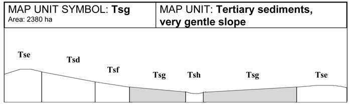
The very gentle sedimentary slopes contain similar soils to those found on the gentle slopes (Tsf). Bleached and mottled Dermosols with a sodic subsoil are common. Drainage of these soils is slow and waterlogging is common in winter and spring. Soil depth is greater on these slopes and may reach two metres. Sheet and rill erosion are uncommon because of the gentle slope, however sodic subsoils have contributed to gully erosion on this unit. Land use on this unit is primarily grazing, however areas with recently deposited sands may be used for horticultural purposes.
SITE CHARACTERISTICS
| Parent Material Age: | Tertiary | Depth to Seas. Watertable: | > 1.0 m | |
| Parent Material Lithology: | Sediments | Flooding Risk: | Low | |
| Landform Pattern: | Low hills | Drainage: | Imperfectly drained | |
| Landform Element: | Very gentle slope | Rock Outcrop: | < 2% | |
| Slope a) common: | 2% | Depth to Hard Rock: | > 1.5 m | |
| Slope b) range: | 1-3% | |||
| Potential Recharge to Groundwater: | Low | |||
| Major Native Vegetation Species: | Melaleuca | |||
| Present Land Use: | Grazing (major), Horticulture (minor) | |||
| Length of Growing Season: | 8 months | |||
LAND DEGRADATION
Degradation Processes | Water Erosion | Wind Erosion | Mass Movement | Salting | Acidification | |
sheet/rill | gully | |||||
Susceptibility | Very low | Low | Very low | Low | Moderate | Moderate |
Incidence | Low | Low | Low | Very low | Low | |
PROFILE DESCRIPTION
A1 | 0-20 cm | Very dark grey (10YR3/1) fine sandy clay loam, moderate to strong subangular blocky to prismatic structure, peds 10-20 mm rough fabric, weak consistence (moist), pH 5.9. Abrupt transition to: |
A2 | 20-45 cm | Pale brown (10YR6/3) fine sandy clay loam, bleached (10YR7/2) when dry, weak subangular blocky structure, peds 10-20 mm, rough fabric, weak consistence (moist), pH 5.8. Gradual transition to: |
B1 | 45-70 cm | Greyish brown (10YR5/2) light medium clay, many faint medium yellow and orange mottles, weak prismatic structure, peds 10-20 mm, smooth fabric, firm consistence (moderately moist). Gradual transition to: |
B21 | 70-150+ cm | Light brownish grey (10YR6/2) heavy clay, many coarse distinct orange and yellow mottles, strong subangular blocky structure, peds 5-10 mm, smooth fabric, firm consistence (moderately moist), pH 5.5. |
Classification
| Factual Key: | Gn3.84 |
| Australian Soil Classification: | Bleached-Sodic Eutrophic, Brown DERMOSOL; medium, slightly gravelly, clay loamy/clayey, very deep (confidence level 2) |
| Unified Soil Group: | CH |
Interpretation of Laboratory ANAlysis*
Horizon | pH (CaCl2) | % Gravel | EC (salts) | Nutrient Status | P | K | Al | Organic Matter | Dispersibility |
A1 | 4.8 | 7 | VL | VL | D | D | S | H | VL |
A2 | 4.6 | 10 | VL | L | D | D | T | L | VL |
B1 | NA | 20 | NA | NA | NA | NA | NA | NA | M |
B21 | 4.5 | 25 | VL | L | D | D | S | VL | L |
T: Potentially Toxic NA: Not Available * see Appendix D for analytical results ** Strongly Acidic
Soil Profile Characteristics:
| Permeability: | Slow (average 15 mm/day, range 10-25 mm/day) |
| Available Water Capacity: | Very high (220 mm H2O) |
| Linear Shrinkage (B horizon): | Moderate (17%) |
C. LAND CAPABILITY ASSESSMENT
Land Use | Class | Major Limiting Feature(s)/Land Use |
| Agriculture | C2T1S3 | Permeability-rainfall index, gravel and stone content |
| Effluent Disposal (septic tanks) | 4 | Drainage, permeability |
| Farm Dams | 3 | Permeability, linear shrinkage, low dispersibility of subsoil |
| Building Foundations slab stumps/footings | 4 4 | Drainage Drainage |
| Secondary Roads | 4 | Drainage |
| Rural Residential Development | 4 | Effluent disposal, building foundations, secondary roads |
A. GENERAL DESCRIPTION
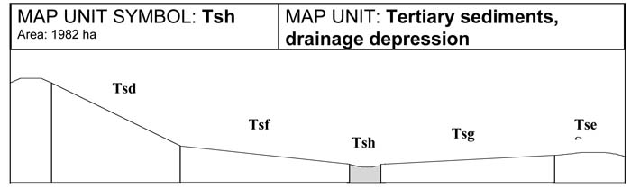
Drainage lines which run through the sedimentary terrain are generally wide with soil profiles reaching two metres in depth. In many situations, minor drainage lines may not have been mapped due to restrictions of scale, especially in steeper units. Bleached and mottled grey Dermosols and Sodosols are common. Gully erosion occurs in this unit due to the dispersive nature of the subsoil and salting also occurs. Seasonal flooding is common, and waterlogging is a problem in winter and spring months. The leaching of soil nutrients has resulted in the formation of acidic topsoils.
SITE CHARACTERISTICS
| Parent Material Age: | Tertiary | Depth to Seas. Watertable: | > 1.0 m | |
| Parent Material Lithology: | Sediments | Flooding Risk: | Moderate | |
| Landform Pattern: | Low hills | Drainage: | Imperfectly drained | |
| Landform Element: | Drainage depression | Rock Outcrop: | Nil | |
| Slope a) common: | 3% | Depth to Hard Rock: | > 1.5 m | |
| Slope b) range: | 0-7% | |||
| Potential Recharge to Groundwater: | Low | |||
| Major Native Vegetation Species: | Melaleuca, Messmate | |||
| Present Land Use: | Grazing | |||
| Length of Growing Season: | 8 months | |||
LAND DEGRADATION
Degradation Processes | Water Erosion | Wind Erosion | Mass Movement | Salting | Acidification | |
sheet/rill | gully | |||||
Susceptibility | Low | Low | Very low | Low | Moderate | Moderate |
Incidence | Low | low | Low | Very low | Low | NA |
B. SOIL PROFILE
PROFILE DESCRIPTION
| Site C3 | ||
| A1 | 0-25 cm | Very dark greyish brown (10YR3/2) fine sandy clay loam, weak subangular blocky structure, peds 10-20 mm, rough fabric, very weak consistence, pH 4.9. Clear transition to: |
| A2 | 25-60 cm | Greyish brown (10YR5/2) fine sandy clay loam, bleached (10YR8/2) when dry, weak subangular blocky structure, peds 10-20 mm, rough fabric, weak consistence, pH 4.6. Gradual transition to: |
| B1 | 60-100 cm | Greyish brown (10YR5/2) fine sandy clay loam, medium yellow and orange mottles are common, moderate prismatic structure, peds 10-20 mm, rough fabric, firm consistence. Gradual transition to: |
| B2 | 100-135 cm | Light brownwish grey (10YR6/2) medium clay, many coarse distinct yellow and orange mottles, moderate subangular blocky structure, peds 5-10 mm, smooth fabric, firm consistence, pH 5.0. Gradual transition to: |
| B3 | 135-150+ cm | Light yellowish brown (10YR6/4) sandy clay loam, many coarse distinct yellow and orange mottles, weak subangular blocky structure, peds 5-10 mm, rough fabric, firm consistence. |
Classification
| Factual Key: | Dy3.41, Gn3.04 |
| Australian Soil Classification: | Acidic-Sodic, Eutrophic, Grey DERMOSOL (SODOSOL); medium, slightly gravelly, clay loamy/clayey, very deep (confidence level 2) |
| Unified Soil Group: | CL |
Interpretation of Laboratory ANAlysis*
Horizon | pH (CaCl2) | % Gravel | EC (salts) | Nutrient Status | P | K | Al | Organic Matter | Dispersibility |
A1 | 4.1** | 10 | VL | L | S | S | T | H | VL |
A2 | 4.1** | 15 | VL | VL | D | D | T | L | L |
B1 | NA | 10 | NA | NA | NA | NA | NA | NA | M |
B2 | 4.2** | 25 | L | M | D | D | T | VL | H |
T: Potentially Toxic NA: Not Available * see Appendix D for analytical results ** Strongly Acidic
Soil Profile Characteristics:
| Permeability: | Slow (average 15 mm/day, range 10-25 mm/day) |
| Available Water Capacity: | Very high (> 200 mm H2O) |
| Linear Shrinkage (B horizon): | Low (11%) |
C. LAND CAPABILITY ASSESSMENT
Land Use | Class | Major Limiting Feature(s)/Land Use |
| Agriculture | C2T1S3 | Permeability-rainfall index |
| Effluent Disposal (septic tanks) | 4 | Drainage, permeability |
| Farm Dams | 3 | Permeability, depth to seasonal watertable |
| Building Foundations slab stumps/footings | 4 4 | Drainage Drainage |
| Secondary Roads | 4 | Drainage, dispersibility of subsoil |
| Rural Residential Development | 4 | Effluent disposal, building foundations, secondary roads |

© State of Victoria (Agriculture Victoria) 1996 - .

This work, Victorian Resources Online, is licensed under a Creative Commons Attribution 4.0 licence. You are free to re-use the work under that licence, on the condition that you credit the State of Victoria (Agriculture Victoria) as author, indicate if changes were made and comply with the other licence terms.
The licence does not apply to ‘branding’ or some ‘images or photographs’ that may be owned by third parties. We ask you to seek prior approval to use images using the VRO feedback form. Access to higher quality images can also be provided on request.
This page was last updated on .