
LCA Cardinia Shire - Tech Report No. 29 - Chapter 4.2
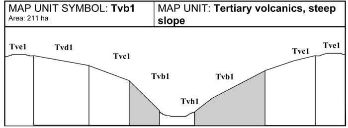
Tvb1 | Tvc1 | Tvd1 | Tve1 | Tvf1 | Tvh1 | Tvb2 | Tvc2 | Tvd2 | Tve2 | Tvf2 | Tvh2
4.2 Tertiary volcanic map units (Tv)
Twelve Tertiary volcanic map units have been identified in the study area. The eruption point of the volcanic flow is located north of Gembrook. Most of the volcanic material from this flow occurs in and around Gembrook, with some occurring around Emerald and Mt Paradise. The volcanic parent material is basalt.
The landscape generally consists of broad flat to gently sloping crests with simple slopes leading into the drainage depressions. In some cases, slopes increase in steepness close to the drainage line. There is some dissection of this landscape with minor drainage lines experiencing some sheet and gully erosion.
Soil development is generally uniform across the landscape, with minor soil variation related to position in the landscape, and often the history of land management in the area. The major soil type that occurs is a well structured, deep red Ferrosol. This soil has high fertility, rapid drainage, and high water holding capacity.
The original vegetation on this unit was dense forest with the most common upper story species being Mountain Ash, Messmate and Narrow-leaved Peppermint.
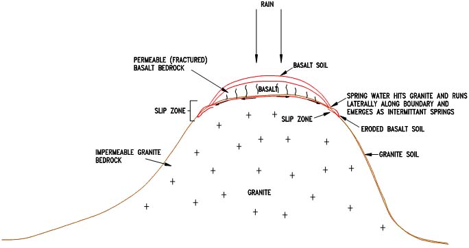
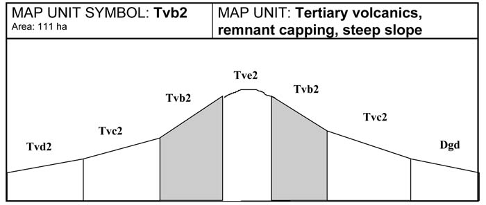
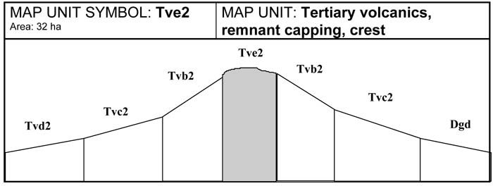
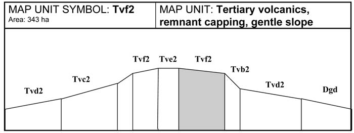
The shallow volcanic cap of Mt Paradise is south of the major volcanic flow (Tvb2 to Tvh2). This shallow cap sits over less permeable granitic material. The unit represents a relatively small area, along a ridge line adjacent to the Toomuc valley. The hilltop (Mt. Paradise) has a broad flat crest leading to steep side slopes. Erosion of these slopes has lead to a build up of colluvial material further down the slope. This colluvial material sits over an impermeable granitic bedrock.
The volcanic soils at Mt Paradise are well structured and free draining, while the underlying basalt rock is deeply fractured. The combination of these characteristics ensures rapid movement of water through the soil profile, however when the groundwater reaches the less permeable granitic material, groundwater movement is restricted. Saturation of the profile occurs above the impermeable granite material, leading to lateral movement of groundwater. This lateral movement appears as intermittent springs at the surface, close to where the two geologies meet (see diagram below). The extra water in the soil profile near the contact zone increases the weight of the soil and reduces its stability. Mass movement (land slip) will occur where the weight of the soil exceeds the shear strength of the soil.
Areas that show evidence of slip activity or have similar characteristics to land with evidence of prior movement are generally considered to be at risk of further mass movement.
Observations at the south western edge of the identified contact zone showed a number of clear slips in drainage lines, and an extensive area which has clearly sunk several metres, probably since clearing for agricultural purposes.
The area designated as nominally slip prone is shown on Map 1a. The units on the slip prone area are designated Tertiary volcanic, remnant capping (Tvb2-Tvf2). From observations, the areas most affected by land slip are gullies where water is concentrated from run-on further up-slope or where water percolates out of springs. The critical areas appear to be basalt capping over granite or sedimentary lithology. The likelihood of a slip occurring is strongly influenced by the steepness of a slope. Most land slips observed were seen on slopes greater than 20 per cent, i.e. Tvc2 and Tvb2 units, with the majority of these slips occurring on slopes over 30 per cent.
Land management considerations
Land degradation is common and widespread on these units. Significant sheet, rill and minor gully erosion occurs on a number of slope classes in this volcanic unit. In an undisturbed situation these soils are not highly susceptible to erosion. However, if the vegetation has been removed and the soil structure broken down through intensive cultivation, erosion will occur. Evidence of current erosion was observed, as well as old erosional events. The effects of this erosion may not always be obvious due to the number of cultivations carried out during the year. That is, after an erosive event, paddocks are cultivated and the gullies are covered over.
An added problem is the presence of chemical contaminants in the soil on a number of properties in this area. On these properties there are some quarantine restrictions against grazing stock. A number of landholders can no longer graze stock. Without the need for pasture to feed stock, fallowed paddocks are more common, thereby increasing areas susceptible to erosion.
The soils derived from the volcanic parent material have a range of favourable attributes that make them suitable for horticultural production, and therefore higher returns for land placed under production. These favourable attributes include soil depth, structure, drainage and nutrient status.
The continual loss of this valuable soil resource through erosion is somewhat ignored in horticultural zones. Much of the erosion occurs on steep slopes and drainage lines. Proven land management practices such as the introduction of grassed waterways, buffer strips and shortened cultivated rows, will minimise soil erosion and enable the effective utilisation of gentle to moderate slopes.
It would also be wise to protect this resource from urban encroachment through some form of agricultural preservation zone, this will ensure that the resource will be available for utilization in the future.
The off-site impacts of soil erosion are also significant. Local waterways carry very heavy sediment loads, which lead to the deterioration of water supplies and stream habitat, including the rapid siltation of farm dams.
While the mass movement of soil in some units is not a major limitation to current grazing practices, it has serious implications for activities that include construction and residential development. Should a change in land use be proposed, such as construction activities involving residential development, it would be prudent for the Cardinia Shire Council to seek expert geotechnical advice. It is also advisable that the south eastern side of Mt Paradise be given due consideration.
Soils of Volcanic origin
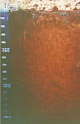 Plate 5 - Map Units Tvb, Tvc, Tvd - Red Ferrosol | 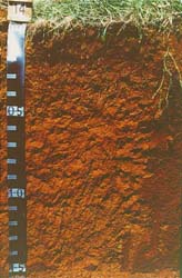 Plate 6 - Map Units Tbe, Tvf - Red Ferrosol |
A. GENERAL DESCRIPTION
This map unit has steep basalt slopes which generally occur closer to a major drainage line than the crest. Red Ferrosols are common on this unit with a lighter topsoil grading into a clayey subsoil. These soils are deep, well structured, free draining and high in free iron in the subsoil. Due to the steepness of these slopes, the soil is subject to serious sheet erosion, particularly where cultivation is attempted.
SITE CHARACTERISTICS
| Parent Material Age: | Quaternary | Depth to Seas. Watertable: | > 1.5 m | |
| Parent Material Lithology: | Basalt | Flooding Risk: | Nil | |
| Landform Pattern: | Steep hills | Drainage: | Well drained | |
| Landform Element: | Hillslope | Rock Outcrop: | < 10% | |
| Slope a) common: | 35% | Depth to Hard Rock: | > 1.5 m | |
| Slope b) range: | > 32% | |||
| Potential Recharge to Groundwater: | High | |||
| Major Native Vegetation Species: | Mountain Ash, Narrow-leaved Peppermint, Messmate, Blackwood | |||
| Present Land Use: | Grazing (major), horticulture (minor) | |||
| Length of Growing Season: | 10 months | |||
LAND DEGRADATION
Degradation Processes | Water Erosion | Wind Erosion | Mass Movement | Salting | Acidification | |
sheet/rill | gully | |||||
| Susceptibility | Moderate | Low | Very low | Very high | Low | Moderate |
| Incidence | High | Moderate | Low | High | Low | NA |
B. SOIL PROFILE
PROFILE DESCRIPTION
| Site S14 | ||
A1 | 0-20 cm | Dark brown (7.5YR3/2) light clay, weak subangular blocky structure, peds 20-50 mm, rough fabric, very firm consistence, pH 5.0. Abrupt transition to: |
B1 | 20-50 cm | Dark reddish brown (5YR3/2) light clay, moderate subangular blocky structure, peds 5-10 mm, rough fabric, firm consistence, pH 5.2. Gradual transition to: |
B21 | 50-100 cm | Reddish brown (2.5YR4/4) light medium clay, moderate polyhedral structure, peds 10-20 mm, rough fabric, firm consistence, pH 5.4. Diffuse transition to: |
B22 | 100-150+ cm | Reddish brown (2.5YR4/4) light medium clay, coarse distinct red mottles are common, strong subangular blocky structure, peds 5-10 mm, smooth fabric, weak consistence, pH 5.5. |
Classification
| Factual Key: | Uf5.12 |
| Australian Soil Classification: | Melacic, Mesotrophic, Red FERROSOL; medium, non-gravelly, clayey/clayey, very deep, (confidence level 2) |
| Unified Soil Group: | CH |
Interpretation of Laboratory ANAlysis*
Horizon | pH (CaCl2) | % Gravel | EC (salts) | Nutrient Status | P | K | Al | Organic Matter | Dispersibility |
A1 | 4.2** | 0 | VL | L | S | S | T | H | L |
B1 | 4.4** | 0 | VL | L | D | S | T | L | L |
B21 | 4.8 | 0 | VL | VL | D | D | T | VL | L |
T: Potentially Toxic NA: Not Available * see Appendix D for analytical results ** Strongly Acidic
Soil Profile Characteristics:
| Permeability: | Rapid (average 730 mm/day, range 190-975 mm/day) |
| Available Water Capacity: | Very high (> 200 mm/H2O) |
| Linear Shrinkage (B horizon): | Moderate (17%) |
C. LAND CAPABILITY ASSESSMENT
| Land Use | Class | Major Limiting Feature(s)/Land Use |
| Agriculture | C2T5S3 | Slope |
| Effluent Disposal (septic tanks) | 5 | Slope |
| Farm Dams | 5 | Slope, susceptibility to slope failure |
| Building Foundations slab stumps/footings | 5 5 | Slope, susceptibility to slope failure Susceptibility to slope failure |
| Secondary Roads | 5 | Slope, susceptibility to slope failure |
| Rural Residential Development | 5 | Secondary roads, farm dams, building foundations, secondary roads |
A. GENERAL DESCRIPTION
This map unit is quite common in the Gembrook area. Even though the slopes of this unit are steep, intensive cropping is still common. These units occur closer to the drainage line than the crest, and often run directly to the drainage line. Soil erosion is common; water concentrated in drainage lines moves large amounts of soil, especially if it has been recently cultivated. The common soil type on this unit is a deep red Ferrosol with a clay loam topsoil grading to a clayey subsoil. These soils are well structured, free draining, fertile, and high in free iron in the subsoil.
SITE CHARACTERISTICS
| Parent Material Age: | Tertiary | Depth to Seas. Watertable: | > 1.5 m | |
| Parent Material Lithology: | Basalt | Flooding Risk: | Nil | |
| Landform Pattern: | Rolling Hills | Drainage: | Well drained | |
| Landform Element: | Hillslope | Rock Outcrop: | < 1% | |
| Slope a) common: | 26% | Depth to Hard Rock: | > 1.5m | |
| Slope b) range: | 21-32 % | |||
| Potential Recharge to Groundwater: | High | |||
| Major Native Vegetation Species: | Mountain Ash, Blackwood, Narrow-leaved Peppermint | |||
| Present Land Use: | Horticulture | |||
| Length of Growing Season: | 10 months | |||
LAND DEGRADATION
Degradation Processes | Water Erosion | Wind Erosion | Mass Movement | Salting | Acidification | |
sheet/rill | gully | |||||
Susceptibility | Low-mod | Low-mod | Very low | High | Low | Moderate |
Incidence | Moderate | Low | Very low | Moderate | Low | NA |
B. SOIL PROFILE
PROFILE DESCRIPTION
| Site S14 | ||
| A1 | 0-20 cm | Dark brown (7.5YR3/2) light clay, weak subangular blocky structure, peds 20-50 mm, rough fabric, very firm consistence, pH 5.0. Abrupt transition to: |
| B1 | 20-55 cm | Reddish brown (5YR4/3) light clay, moderate polyhedral structure, peds 10-20 mm, rough fabric, firm consistence, pH 5.2. Gradual transition to: |
| B21 | 55-105 cm | Reddish brown (2.5YR4/4) light medium clay, moderate polyhedral structure, peds 10-20 mm, rough fabric, firm consistence, pH 5.4. Diffuse transition to: |
| B22 | 105-150+cm | Reddish brown (2.5YR4/4) light medium clay, coarse distinct red mottles are common, strong subangular blocky structure, peds 5-10 mm, smooth fabric, weak consistence, pH 5.5. |
Classification
| Factual Key: | Uf5.12 |
| Australian Soil Classification: | Melacic, Mesotrophic, Red FERROSOL; medium, non-gravelly, clayey/clayey, very deep (confidence level 2) |
| Unified Soil Group: | CH |
Interpretation of Laboratory ANAlysis*
Horizon | pH (CaCl2) | % Gravel | EC (salts) | Nutrient Status | P | K | Al | Organic Matter | Dispersibility |
A1 | 4.2** | 0 | VL | L | S | S | T | H | L |
B1 | 4.4** | 0 | VL | L | D | S | T | L | L |
B21 | 4.8 | 0 | VL | VL | D | D | T | VL | L |
T: Potentially Toxic NA: Not Available * see Appendix D for analytical results ** Strongly Acidic
Soil Profile Characteristics:
| Permeability: | Rapid (average 730 mm/day, range 190-975 mm/day) |
| Available Water Capacity: | Very high (> 200 mm H2O) |
| Linear Shrinkage (B horizon): | Moderate (17%) |
C. LAND CAPABILITY ASSESSMENT
| Land Use | Class | Major Limiting Feature(s)/Land Use |
| Agriculture | C2T4S2-3 | Slope |
| Effluent Disposal (septic tanks) | 4 | Slope |
| Farm Dams | 5 | Slope |
| Building Foundations slab stumps/footings | 4 4 | Slope, susceptibility to slope failure Susceptibility to slope failure |
| Secondary Roads | 4 | Slope, susceptibility to slope failure |
| Rural Residential Development | 5 | Farm dams |
A. GENERAL DESCRIPTION
The moderate basalt slopes of this map unit are common in the Gembrook area. The soils are similar to those of other volcanic units in the area. These soils are deep, well structured, freely drained red Ferrosols, however, they are very susceptible to erosion if there is little vegetative cover, or if they have been recently cultivated. These fertile soils are commonly used for horticultural purposes.
SITE CHARACTERISTICS
| Parent Material Age: | Tertiary | Depth to Seas. Watertable: | > 1.5 m | |
| Parent Material Lithology: | Basalt | Flooding Risk: | Nil | |
| Landform Pattern: | Rolling hills | Drainage: | Well drained | |
| Landform Element: | Hillslope | Rock Outcrop: | < 10% | |
| Slope a) common: | 16% | Depth to Hard Rock: | > 1.5m | |
| Slope b) range: | 11-20% | |||
| Potential Recharge to Groundwater: | Moderate | |||
| Major Native Vegetation Species: | Mountain Ash, Blackwood, Narrow-leaved Peppermint | |||
| Present Land Use: | Horticulture, grazing | |||
| Length of Growing Season: | 10 months | |||
LAND DEGRADATION
Degradation Processes | Water Erosion | Wind Erosion | Mass Movement | Salting | Acidification | |
sheet/rill | gully | |||||
Susceptibility | Low-mod | Low | Very low | High | Low | Moderate |
Incidence | Moderate | Low | Very low | Moderate | Low | NA |
B. SOIL PROFILE
PROFILE DESCRIPTION
| Site S14 | ||
| A1 | 0-20 cm | Dark brown (7.5YR3/2) light clay, weak subangular blocky structure, peds 20-50 mm, rough fabric, very firm consistence, pH 5.0. Abrupt transition to: |
| B1 | 20-60 cm | Reddish brown (5YR4/3) light clay, moderate polyhedral structure, peds 10-20 mm, rough fabric, firm consistence, pH 5.2. Gradual transition to: |
| B21 | 60-110 cm | Reddish brown (2.5YR4/4) medium clay, moderate polyhedral structure, peds 10-20 mm, rough fabric, firm consistence, pH 5.4. Gradual transition to: |
| B3 | 110-150+ cm | Reddish brown (2.5YR4/4) medium clay, strong subangular blocky structure, peds 5-10 mm, smooth fabric, weak consistence, pH 5.5. |
Classification
| Factual Key: | Uf5.12 |
| Australian Soil Classification: | Melacic, Mesotrophic, Red FERROSOL; medium, non-gravelly, clayey/clayey, very deep (confidence level 2) |
| Unified Soil Group: | CH |
Interpretation of Laboratory ANAlysis*
Horizon | pH (CaCl2) | % Gravel | EC (salts) | Nutrient Status | P | K | Al | Organic Matter | Dispersibility |
A1 | 4.2** | 0 | VL | L | S | S | T | H | L |
B1 | 4.4** | 0 | VL | L | D | S | T | L | L |
B21 | 4.8. | 0 | VL | VL | D | D | T | VL | L |
T: Potentially Toxic NA: Not Available * see Appendix D for analytical results ** Strongly Acidic
Soil Profile Characteristics:
| Permeability: | Rapid (average 730 mm/day, range 190-975 mm/day) |
| Available Water Capacity: | Very high (> 200 mm H2O) |
| Linear Shrinkage (B horizon): | Moderate (17%) |
C. LAND CAPABILITY ASSESSMENT
| Land Use | Class | Major Limiting Feature(s)/Land Use |
| Agriculture | C2T3S2-3 | Slope |
| Effluent Disposal (septic tanks) | 3 | Slope |
| Farm Dams | 4 | Slope, permeability, susceptibility to slope failure |
| Building Foundations slab stumps/footings | 4 4 | Slope, susceptibility to slope failure Susceptibility to slope failure |
| Secondary Roads | 4 | Slope, susceptibility to slope failure |
| Rural Residential Development | 4 | Secondary roads, farm dams, building foundations |
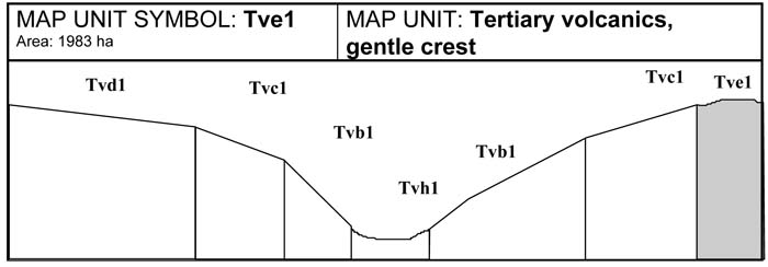
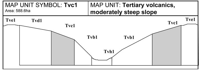
A. GENERAL DESCRIPTION
Gentle crests and ridges are common in and around Gembrook. The hill crests may be gently sloping to flat, however, the side slope leading up to these crests are steeper. The shape of the crest is not a discreet, well defined hilltop and could be better described as a long undulating ridge line. Soils on the crests are similar to those on the ridges that are slightly lower in the landscape. Red Ferrosols are common; these soils are deep, well structured and free draining. Because these soils occur on gentle slopes, erosion is less of a problem. These fertile soils are commonly utilised for horticultural production.
SITE CHARACTERISTICS
| Parent Material Age: | Quaternary | Depth to Seas. Watertable: | > 1.5 m | |
| Parent Material Lithology: | Basalt | Flooding Risk: | Nil | |
| Landform Pattern: | Undulating Hills | Drainage: | Well drained | |
| Landform Element: | Hillcrest | Rock Outcrop: | < 5% | |
| Slope a) common: | 2% | Depth to Hard Rock: | > 1.5 m | |
| Slope b) range: | 1-4% | |||
| Potential Recharge to Groundwater: | Moderate | |||
| Major Native Vegetation Species: | Mountain Ash, Blackwood, Narrow-leaved Peppermint | |||
| Present Land Use: | Horticulture | |||
| Length of Growing Season: | 10 months | |||
LAND DEGRADATION
Degradation Processes | Water Erosion | Wind Erosion | Mass Movement | Salting | Acidification | |
sheet/rill | gully | |||||
Susceptibility | Low | Very low | Very low | Low | Low | Moderate |
Incidence | Low | Low | Very low | Low | Low | NA |
B. SOIL PROFILE
PROFILE DESCRIPTION
| Site S15 | ||
A1 | 0-30 cm | Reddish brown (5YR4/4) light medium clay, strong polyhedral structure, peds 5-10 mm, rough fabric, very firm consistence, pH 4.7. Gradual transition to: |
B2 | 30-100 cm | Dark reddish brown (5YR3/3) medium clay, strong polyhedral structure, peds 10-20 mm, smooth fabric, firm consistence, pH 5.4. Diffuse transition to: |
B3 | 100-150+ cm | Reddish brown (5YR4/4) light medium clay, strong polyhedral structure, peds 20-50 mm, smooth fabric, firm consistence, pH 5.3. |
Classification
| Factual Key: | Uf5.21 |
| Australian Soil Classification: | Haplic, Mesotrophic, Red FERROSOL; thick, non-gravelly, clayey/clayey, very deep (confidence level 2) |
| Unified Soil Group: | MH |
Interpretation of Laboratory ANAlysis*
Horizon | pH (CaCl2) | % Gravel | EC (salts) | Nutrient Status | P | K | Al | Organic Matter | Dispersibility |
A1 | 4.3** | < 1 | VL | L | S | S | T | H | L |
B2 | 5.1 | < 1 | VL | L | D | S | S | L | L |
B3 | 5.7 | 15 | VL | VL | D | D | S | VL | L |
T: Potentially Toxic NA: Not Available * see Appendix D for analytical results ** Strongly Acidic
Soil Profile Characteristics:
| Permeability: | Rapid (average 730 mm/day, range 190-975 mm/day) |
| Available Water Capacity: | Very high (260 mm H2O) |
| Linear Shrinkage (B horizon): | Moderate (13.5%) |
C. LAND CAPABILITY ASSESSMENT
| Land Use | Class | Major Limiting Feature(s)/Land Use |
| Agriculture | C2T1S2 | Nil |
| Effluent Disposal (septic tanks) | 2 | Nil |
| Farm Dams | 4 | Permeability |
| Building Foundations slab stumps/footings | 2 3 | Nil Linear Shrinkage |
| Secondary Roads | 3 | Linear Shrinkage, USG |
| RuralResidential Development | 4 | Farm Dams |
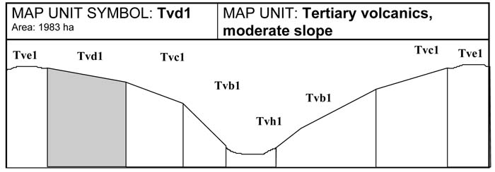
A. GENERAL DESCRIPTION
This map unit is commonly found closer to the crest than to the drainage line. The major soil type is a deep, well structured red Ferrosol. This unit is less prone to erosion because of the lower slope gradients. Some erosion may occur where long slopes are cultivated. This unit isparticularly valuable for horticultural production.
SITE CHARACTERISTICS
| Parent Material Age: | Tertiary | Depth to Seas. Watertable: | > 1.5 m | |
| Parent Material Lithology: | Basalt | Flooding Risk: | Nil | |
| Landform Pattern: | Undulating Hills | Drainage: | Well drained | |
| Landform Element: | Hillslope | Rock Outcrop: | 0% | |
| Slope a) common: | 7% | Depth to Hard Rock: | > 1.5m | |
| Slope b) range: | 4-10 % | |||
| Potential Recharge to Groundwater: | Low | |||
| Major Native Vegetation Species: | Mountain Ash, Blackwood, Narrow-leaved Peppermint, Messmate | |||
| Present Land Use: | Horticulture | |||
| Length of Growing Season: | 10 months | |||
LAND DEGRADATION
Degradation Processes | Water Erosion | Wind Erosion | Mass Movement | Salting | Acidification | |
sheet/rill | gully | |||||
Susceptibility | Low-mod | Low | Very low | Low | Low | Moderate |
Incidence | Moderate | Low | Very low | Low | Low | NA |
B. SOIL PROFILE
PROFILE DESCRIPTION
| Site S15 | ||
A1 | 0-30 cm | Reddish brown (5YR4/4) light medium clay, strong polyhedral structure, peds 5-10 mm, rough fabric, very firm consistence, pH 4.7. Gradual transition to: |
B2 | 30-110 cm | Dark reddish brown (5YR3/3) medium clay, moderate polyhedral structure, peds 10-20 mm, smooth fabric, firm consistence, pH 5.4. Gradual transition to: |
B3 | 110-150+ cm | Greyish brown (10YR5/2) light medium clay, strong polyhedral structure, peds 20-50 mm, smooth fabric, rigid firm consistence, pH 5.3. |
Classification
| Factual Key: | Uf5.12 |
| Australian Soil Classification: | Haplic, Mesotrophic, Red FERROSOL; thick, non-gravelly, clayey/clayey, very deep (confidence level 2) |
| Unified Soil Group: | MH |
Interpretation of Laboratory ANAlysis*
Horizon | pH (CaCl2) | % Gravel | EC (salts) | Nutrient Status | P | K | Al | Organic Matter | Dispersibility |
A1 | 4.3** | < 1 | VL | L | S | S | T | H | L |
B2 | 5.1 | < 1 | VL | L | D | S | S | L | L |
B3 | 5.7 | 15 | VL | VL | D | D | S | VL | L |
T: Potentially Toxic NA: Not Available * see Appendix D for analytical results ** Strongly Acidic
Soil Profile Characteristics:
| Permeability: | Rapid (average 730 mm/day, range 190-975 mm/day) |
| Available Water Capacity: | Very high (> 200 mm H2O) |
| Linear Shrinkage (B horizon): | Moderate (13.5 %) |
C. LAND CAPABILITY ASSESSMENT
| Land Use | Class | Major Limiting Feature(s)/Land Use |
| Agriculture | C2T2S2-3 | Susceptibility to sheet erosion |
| Effluent Disposal (septic tanks) | 2 | Nil |
| Farm Dams | 4 | Permeability |
| Building Foundations slab stumps/footings | 3 3 | Slope Linear shrinkage |
| Secondary Roads | 3 | Linear shrinkage, USG |
| Rural Residential Development | 4 | Farm dams |
A. GENERAL DESCRIPTION
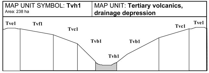
Drainage depressions occur throughout the volcanic terrain. Due to the position in the landscape, drainage depressions are highly variable and frequently suffer from significant sheet and gully erosion. The soils are generally fertile, well structured and free draining red ferrosols. In general, steep upper drainage lines will most likely have sufferred significant erosion over time, while the soils of lower drainage lines are likely to have been built up from soil deposition. In Gembrook, dams are commonly built in major drainage lines to support horticultural practices.
SITE CHARACTERISTIC
| Parent Material Age: | Tertiary | Depth to Seas. Watertable: | > 1.5 m | |
| Parent Material Lithology: | Basalt | Flooding Risk: | Nil | |
| Landform Pattern: | Undulating Hills | Drainage: | Moderately well drained | |
| Landform Element: | Hillslope | Rock Outcrop: | 0% | |
| Slope a) common: | 8% | Depth to Hard Rock: | > 2.0m | |
| Slope b) range: | 5-20 % | |||
| Potential Recharge to Groundwater: | Low | |||
| Major Native Vegetation Species: | Blackwood, Narrow-leaved Peppermint, Messmate | |||
| Present Land Use: | Horticulture, dams | |||
| Length of Growing Season: | 10 months | |||
LAND DEGRADATION
Degradation Processes | Water Erosion | Wind Erosion | Mass Movement | Salting | Acidification | |
sheet/rill | gully | |||||
| Susceptibility | Low-mod | Low-mod | Very low | High | Moderate | Moderate |
| Incidence | Moderate | Moderate | Very low | Moderate | Low | NA |
B. SOIL PROFILE
PROFILE DESCRIPTION
| Site S14 | ||
A1 | 0-35 cm | Dark brown (7.5YR3/2) light clay, moderate subangular blocky structure, peds 20-50 mm, rough fabric, very firm consistence, pH 5.0. Clear transition to: |
B1 | 35-60 cm | Reddish brown (5YR4/3) light clay, moderate polyhedral structure, peds 10-20 mm, rough and smooth fabric, firm consistence, pH 5.2. Gradual transition to: |
B21 | 60-110 cm | Dark reddish brown (2.5YR4/4) medium clay, moderate polyhedral structure, peds 10-20 mm, rough and smooth fabric, firm consistence, pH 5.4. Diffuse transition to: |
B22 | 110-150+ cm | Reddish brown (2.5YR4/4) light medium clay, coarse distinct red mottles are common, strong subangular blocky structure, peds 5-10 mm, smooth fabric, weak consistence, pH 5.5. |
Classification
| Factual Key: | Uf5.12 |
| Australian Soil Classification: | Melacic, Mesotrophic, Red FERROSOL; thick, non-gravelly, clayey/clayey, very deep (confidence level 2) |
| Unified Soil Group: | CH |
Interpretation of Laboratory ANAlysis*
Horizon | pH (CaCl2) | % Gravel | EC (salts) | Nutrient Status | P | K | Al | Organic Matter | Dispersibility |
A1 | 4.2** | 0 | VL | L | S | S | T | H | L |
B1 | 4.4** | 0 | VL | L | D | S | T | L | L |
B21 | 4.8 | 0 | VL | VL | D | D | T | VL | L |
T: Potentially Toxic NA: Not Available * see Appendix D for analytical results ** Strongly Acidic
Soil Profile Characteristics:
| Permeability: | Moderate (average 350 mm/day, range 100-480 mm/day) |
| Available Water Capacity: | Very high (> 200 mm H2O) |
| Linear Shrinkage (B horizon): | Moderate (17%) |
C. LAND CAPABILITY ASSESSMENT
| Land Use | Class | Major Limiting Feature(s)/Land Use |
| Agriculture | C2T2-3S2-3 | Susceptibility to sheet and gully erosion, slope |
| Effluent Disposal (septic tanks) | 3 | Drainage |
| Farm Dams | 4 | Permeability, susceptibility to slope failure |
| Building Foundations slab stumps/footings | 4 4 | Slope, susceptibility to slope failure Susceptibility to slope failure |
| Secondary Roads | 4 | Susceptibility to slope failure |
| Rural Residential Development | 4 | Secondary roads, farm dams, building foundations |
A. GENERAL DESCRIPTION
Steep slopes are associated with the crests of the Mt Paradise area. A deep, well structured, free draining red Ferrosol soil is present. Due to the steepness of slopes, serious soil erosion and land slippage can occur. Land slips are readily observed in this map unit. Natural springs may occur on these units. Because of this, soils profiles may be wet for many months of the year. This unit is mostly used for grazing.
SITE CHARACTERISTICS
| Parent Material Age: | Quaternary | Depth to Seas. Watertable: | > 1.5 m | |
| Parent Material Lithology: | Basalt | Flooding Risk: | Nil | |
| Landform Pattern: | Steep Hills | Drainage: | Well drained | |
| Landform Element: | Hillslope | Rock Outcrop: | < 5% | |
| Slope a) common: | 35% | Depth to Hard Rock: | > 1.5 m | |
| Slope b) range: | > 32% | |||
| Potential Recharge to Groundwater: | High | |||
| Major Native Vegetation Species: | Mountain Ash, Blackwood, Narrow-leaved Peppermint, Messmate | |||
| Present Land Use: | Grazing | |||
| Length of Growing Season: | 10 months | |||
LAND DEGRADATION
Degradation Processes | Water Erosion | Wind Erosion | Mass Movement | Salting | Acidification | |
sheet/rill | gully | |||||
Susceptibility | Mod-high | Low-mod | Very low | Very high | Low | Moderate |
Incidence | High | Moderate | Low | Very high | Low | NA |
B. SOIL PROFILE
PROFILE DESCRIPTION
| Site S14 | ||
A1 | 0-20 cm | Dark brown (7.5YR3/2) light clay, weak subangular blocky structure, peds 20-50 mm, rough fabric, very firm consistence, pH 5.0. Abrupt transition to: |
B1 | 20-50 cm | Dark reddish brown (5YR3/2) light clay, moderate subangular blocky structure, peds 5-10 mm, rough fabric, firm consistence, pH 5.2. Gradual transition to: |
B21 | 50-100 cm | Reddish brown (2.5YR4/4) light medium clay, moderate polyhedral structure, peds 10-20 mm, rough fabric, firm consistence, pH 5.4. Diffuse transition to: |
B22 | 100-150+ cm | Reddish brown (2.5YR4/4) light medium clay, coarse distinct red mottles are common, strong subangular blocky structure, peds 5-10 mm, smooth fabric, weak consistence, pH 5.5. |
Classification
| Factual Key: | Uf5.12 |
| Australian Soil Classification: | Melacic, Mesotrophic, Red FERROSOL; medium, non-gravelly, clayey/clayey, very deep (confidence level 2) |
| Unified Soil Group: | CH |
Interpretation of Laboratory ANAlysis*
Horizon | pH (CaCl2) | % Gravel | EC (salts) | Nutrient Status | P | K | Al | Organic Matter | Dispersibility |
A1 | 4.2** | 0 | VL | L | S | S | T | H | L |
B1 | 4.4** | 0 | VL | L | D | S | T | L | L |
B21 | 4.8 | 0 | VL | VL | D | D | T | VL | L |
T: Potentially Toxic NA: Not Available * see Appendix D for analytical results ** Strongly Acidic
Soil Profile Characteristics:
| Permeability: | Rapid (average 730 mm/day, range 190-975 mm/day) |
| Available Water Capacity: | Very high (> 200 mm H2O) |
| Linear Shrinkage (B horizon): | Moderate (17%) |
C. LAND CAPABILITY ASSESSMENT
| Land Use | Class | Major Limiting Feature(s)/Land Use |
| Agriculture | C2T5S3-4 | Slope |
| Effluent Disposal (septic tanks) | 5 | Slope |
| Farm Dams | 5 | Slope, susceptibility to slope failure |
| Building Foundations slab stumps/footings | 5 5 | Slope, susceptibility to slope failure Susceptibility to slope failure |
| Secondary Roads | 5 | Slope, susceptibility to slope failure |
| Rural Residential Development | 5 | Secondary roads, farm dams, building foundations, secondary roads |
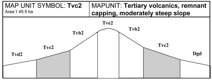
These moderately steep slopes occur closer to the crest than to the drainage line. The common soil type is a red Ferrosol with clay loam topsoils grading to clayey subsoils. In wetter areas, brown Dermosol soils can be found. This unit is generally used for grazing. Evidence of prior landslips are visible on this unit. The moderately steep slopes in this area should be treated as slip prone. Closer investigation should be carried out before any development of these areas occur. This unit is often dissected by minor drainage lines which are susceptible to sheet and gully erosion, especially where cultivation has taken place. Water concentrated in drainage lines will also increase the risk of landslips.
SITE CHARACTERISTICS
| Parent Material Age: | Tertiary | Depth to Seas. Watertable: | > 1.5 m | |
| Parent Material Lithology: | Basalt | Flooding Risk: | Nil | |
| Landform Pattern: | Rolling Hills | Drainage: | Well drained | |
| Landform Element: | Hillslope | Rock Outcrop: | < 1% | |
| Slope a) common: | 26% | Depth to Hard Rock: | > 1.5m | |
| Slope b) range: | 21-32 % | |||
| Potential Recharge to Groundwater: | High | |||
| Major Native Vegetation Species: | Mountain Ash, Blackwood, Narrow-leaved Peppermint, Messmate | |||
| Present Land Use: | Grazing | |||
| Length of Growing Season: | 10 months | |||
LAND DEGRADATION
Degradation Processes | Water Erosion | Wind Erosion | Mass Movement | Salting | Acidification | |
sheet/rill | gully | |||||
Susceptibility | Low-mod | Low-mod | Very low | High | Low | Moderate |
Incidence | Moderate | Low | Very low | Very high | Low | NA |
B. SOIL PROFILE
PROFILE DESCRIPTION
| Site S14 | ||
A1 | 0-20 cm | Dark brown (7.5YR3/2) light clay, weak subangular blocky structure, peds 20-50 mm, rough fabric, very firm consistence, pH 5.0. Abrupt transition to: |
B1 | 20-55 cm | Reddish brown (5YR4/3) light clay, moderate polyhedral structure, peds 10-20 mm, rough fabric, firm consistence, pH 5.2. Gradual transition to: |
B21 | 55-105 cm | Reddish brown (2.5YR4/4) light medium clay, moderate polyhedral structure, peds 10-20, rough fabric, firm consistence, pH 5.4. Diffuse transition to: |
B22 | 105-150+ cm | Reddish brown (2.5YR4/4) light medium clay, coarse distinct red mottles are common, strong subangular blocky structure, peds 5-10 mm, smooth fabric, weak consistence, pH 5.5. |
Classification
| Factual Key: | Uf5.12 |
| Australian Soil Classification: | Melacic, Mesotrophic, Red FERROSOL; medium, non-gravelly, clayey/clayey, very deep (confidence level 2) |
| Unified Soil Group: | CH |
Interpretation of Laboratory ANAlysis*
Horizon | pH (CaCl2) | % Gravel | EC (salts) | Nutrient Status | P | K | Al | Organic Matter | Dispersibility |
A1 | 4.2** | 0 | VL | L | S | S | T | H | L |
B1 | 4.4** | 0 | VL | L | D | S | T | L | L |
B21 | 4.8 | 0 | VL | VL | D | D | T | VL | L |
T: Potentially Toxic NA: Not Available * see Appendix D for analytical results ** Strongly Acidic
Soil Profile Characteristics:
| Permeability: | Rapid (average 730 mm/day, range 190-975 mm/day) |
| Available Water Capacity: | Very high (> 200 mm H2O) |
| Linear Shrinkage (B horizon): | Moderate (17%) |
C. LAND CAPABILITY ASSESSMENT
| Land Use | Class | Major Limiting Feature(s)/Land Use |
| Agriculture | C2T4S2-3 | Slope |
| Effluent Disposal (septic tanks) | 4 | Slope |
| Farm Dams | 5 | Slope |
| Building Foundations slab stumps/footings | 4 4 | Slope, susceptibility to slope failure Susceptibility to slope failure |
| Secondary Roads | 4 | Slope, susceptibility to slope failure |
| Rural Residential Development | 5 | Farm dams |

A. GENERAL DESCRIPTION
This unit contains moderate slopes which may have a considerable accumulation of colluvial material when they appear lower in the landscape or adjoin drainage lines. The common soil type is a well structured, free draining, red Ferrosol, while minor variants include brown Dermosols. The soils of this unit are less susceptible to land slip and erosion than steeper map units, however some slips were observed in this unit. If any development is to occur, these areas should be subject to further investigation. This unit is generally used for grazing purposes.
SITE CHARACTERISTICS
| Parent Material Age: | Tertiary | Depth to Seas. Watertable: | > 1.5 m | |
| Parent Material Lithology: | Basalt | Flooding Risk: | Nil | |
| Landform Pattern: | Rolling Hills | Drainage: | Well drained | |
| Landform Element: | Hillslope | Rock Outcrop: | < 10% | |
| Slope a) common: | 16% | Depth to Hard Rock: | > 1.5m | |
| Slope b) range: | 11-20% | |||
| Potential Recharge to Groundwater: | Moderate | |||
| Major Native Vegetation Species: | Mountain Ash, Blackwood, Narrow-leaved Peppermint, Messmate | |||
| Present Land Use: | Grazing | |||
| Length of Growing Season: | 10 months | |||
LAND DEGRADATION
Degradation Processes | Water Erosion | Wind Erosion | Mass Movement | Salting | Acidification | |
sheet/rill | gully | |||||
Susceptibility | Low-mod | Low | Very low | High | Low | Moderate |
Incidence | Moderate | Low | Very low | High | Low | NA |
B. SOIL PROFILE
PROFILE DESCRIPTION
| Site S14 | ||
A1 | 0-20 cm | Dark brown (7.5YR3/2) light clay, weak subangular blocky structure, peds 20-50 mm, rough fabric, very firm consistence, pH 5.0. Abrupt transition to: |
B1 | 20-60 cm | Reddish brown (5YR4/3) light clay, moderate polyhedral structure, peds 10-20 mm, rough fabric, firm consistence, pH 5.2. Gradual transition to: |
B21 | 60-110 cm | Reddish brown (2.5YR4/4) medium clay, moderate polyhedral structure, peds 10-20 mm, rough fabric, firm consistence, pH 5.4. Gradual transition to: |
B22 | 110-150+ cm | Reddish brown (2.5YR4/4) medium clay, strong subangular blocky structure, peds 5-10 mm, smooth fabric, weak consistence, pH 5.5. |
Classification
| Factual Key: | Uf5.12 |
| Australian Soil Classification: | Melacic, Mesotrophic, Red FERROSOL; medium, non-gravelly, clayey/clayey, very deep (confidence level 2) |
| Unified Soil Group: | CH |
Interpretation of Laboratory ANAlysis*
Horizon | pH (CaCl2) | % Gravel | EC (salts) | Nutrient Status | P | K | Al | Organic Matter | Dispersibility |
A1 | 4.2** | 0 | VL | L | S | S | T | H | L |
B1 | 4.4** | 0 | VL | L | D | S | T | L | L |
B21 | 4.8 | 0 | VL | VL | D | D | T | VL | L |
T: Potentially Toxic NA: Not Available * see Appendix D for analytical results ** Strongly Acidic
Soil Profile Characteristics:
| Permeability: | Rapid (average 730 mm/day, range 190-975 mm/day) |
| Available Water Capacity: | Very high (> 200 mm H2O) |
| Linear Shrinkage (B horizon): | Moderate (17%) |
C. LAND CAPABILITY ASSESSMENT
| Land Use | Class | Major Limiting Feature(s)/Land Use |
| Agriculture | C2T3S2-3 | Slope |
| Effluent Disposal (septic tanks) | 3 | Slope |
| Farm Dams | 4 | Slope, permeability, susceptibility to slope failure |
| Building Foundations slab stumps/footings | 4 4 | Slope, susceptibility to slope failure Susceptibility to slope failure |
| Secondary Roads | 4 | Slope, susceptibility to slope failure |
| Rural Residential Development | 4 | Secondary roads, farm dams, building foundations |
A. GENERAL DESCRIPTION
Few gentle crests and ridges are present in the Shire. The hill crests may be gently sloping to flat, however the side slopes leading up to these crests can be very steep. The shape of the crest can be described as long undulating ridge line. The soils on the crests are red Ferrosols. These soils are all deep, well structured, free draining and high in free iron. Because these soils occur on gentle slopes, erosion is less of a problem, however crests adjacent to steep side slopes may be subject to land slip.
SITE CHARACTERISTICS
| Parent Material Age: | Quaternary | Depth to Seas. Watertable: | > 1.5 m | |
| Parent Material Lithology: | Basalt | Flooding Risk: | Nil | |
| Landform Pattern: | Rolling Hills | Drainage: | Well drained | |
| Landform Element: | Hillcrest | Rock Outcrop: | < 5% | |
| Slope a) common: | 2% | Depth to Hard Rock: | > 1.5 m | |
| Slope b) range: | 1-4% | |||
| Potential Recharge to Groundwater: | High | |||
| Major Native Vegetation Species: | Mountain Ash, Blackwood, Narrow-leaved Peppermint, Messmate | |||
| Present Land Use: | Grazing | |||
| Length of Growing Season: | 10 months | |||
LAND DEGRADATION
Degradation Processes | Water Erosion | Wind Erosion | Mass Movement | Salting | Acidification | |
sheet/rill | gully | |||||
Susceptibility | Low | Very low | Very low | Low | Low | Moderate |
Incidence | Low | Low | Very low | Moderate | Low | NA |
B. SOIL PROFILE
PROFILE DESCRIPTION
| Site S15 | ||
A1 | 0-30 cm | Reddish brown (5YR4/4) light medium clay, strong polyhedral structure, peds 5-10 mm, rough fabric, very firm consistence, pH 4.7. Gradual transition to: |
B2 | 30-100 cm | Dark reddish brown (5YR3/3) medium clay, strong polyhedral structure, peds 10-20 mm, smooth fabric, firm consistence, pH 5.4. Diffuse transition to: |
B3 | 100-150 cm+ | Reddish brown (5YR4/4) light medium clay, strong polyhedral structure, peds 20-50 mm, smooth fabric, firm consistence, pH 5.3. |
Classification
| Factual Key: | Uf5.21 |
| Australian Soil Classification: | Haplic, Mesotrophic, Red FERROSOL; thick, non-gravelly, clayey/clayey, very deep (confidence level 2) |
| Unified Soil Group: | MH |
Interpretation of Laboratory ANAlysis*
Horizon | pH (CaCl2) | % Gravel | EC (salts) | Nutrient Status | P | K | Al | Organic Matter | Dispersibility |
A1 | 4.3** | < 1 | VL | L | S | S | T | H | L |
B2 | 5.1 | < 1 | VL | L | D | S | T | L | L |
B3 | 5.7 | 15 | VL | VL | D | D | S | VL | L |
T: Potentially Toxic NA: Not Available * see Appendix D for analytical results ** Strongly Acidic
Soil Profile Characteristics:
| Permeability: | Rapid (average 730 mm/day, range 190-975 mm/day) |
| Available Water Capacity: | Very high (260 mm H2O) |
| Linear Shrinkage (B horizon): | Moderate (13.5%) |
C. LAND CAPABILITY ASSESSMENT
| Land Use | Class | Major Limiting Feature(s)/Land Use |
| Agriculture | C2T1S2 | Nil |
| Effluent Disposal (septic tanks) | 2 | Nil |
| Farm Dams | 4 | Permeability |
| Building Foundations slab stumps/footings | 2 3 | Nil Linear Shrinkage |
| Secondary Roads | 3 | Linear Shrinkage, USG |
| Rural Residential Development | 4 | Farm Dams |
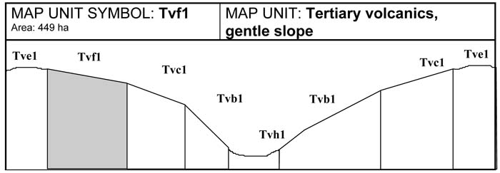
A. GENERAL DESCRIPTION
The gentle slopes are generally found close to crests and broad flat ridges. The soils of this unit are deep, well structured red Ferrosols. This unit is less prone to erosion and land slips because of the gentle slope, however these slopes may slip due to the proximity of steep side slopes. This unit is used mostly for grazing.
SITE CHARACTERISTICS
| Parent Material Age: | Tertiary | Depth to Seas. Watertable: | > 1.5 m | |
| Parent Material Lithology: | Basalt | Flooding Risk: | Nil | |
| Landform Pattern: | Undulating Hills | Drainage: | Well drained | |
| Landform Element: | Hillslope | Rock Outcrop: | 0% | |
| Slope a) common: | 7% | Depth to Hard Rock: | > 1.5m | |
| Slope b) range: | 4-10 % | |||
| Potential Recharge to Groundwater: | High | |||
| Major Native Vegetation Species: | Blackwood, Narrow-leaved Peppermint, Messmate | |||
| Present Land Use: | Grazing | |||
| Length of Growing Season: | 10 months | |||
LAND DEGRADATION
Degradation Processes | Water Erosion | Wind Erosion | Mass Movement | Salting | Acidification | |
sheet/rill | gully | |||||
Susceptibility | Mod-low | Low | Very low | Low | Low | Moderate |
Incidence | Moderate | Low | Very low | Moderate | Low | NA |
B. SOIL PROFILE
PROFILE DESCRIPTION
| Site S15 | ||
A1 | 0-30 cm | Reddish brown (5YR4/4) light medium clay, strong polyhedral structure, peds 5-10 mm, rough fabric, very firm consistence, pH 4.7. Gradual transition to: |
B2 | 30-110 cm | Dark reddish brown (5YR3/3) medium clay, moderate polyhedral structure, peds 10-20 mm, smooth fabric, firm consistence, pH 5.4. Gradual transition to: |
B3 | 110-150 cm | Greyish brown (10YR5/2) light medium clay, strong polyhedral structure, peds 20-50 mm, smooth fabric, rigid firm consistence, pH 5.3. |
Classification
| Factual Key: | Uf5.12 |
| Australian Soil Classification: | Haplic, Mesotrophic, Red FERROSOL; thick, non-gravelly, clayey/clayey, very deep (confidence level 2) |
| Unified Soil Group: | MH |
Interpretation of Laboratory ANAlysis*
Horizon | pH (CaCl2) | % Gravel | EC (salts) | Nutrient Status | P | K | Al | Organic Matter | Dispersibility |
A1 | 4.3** | < 1 | VL | L | S | S | T | H | L |
B2 | 5.1 | < 1 | VL | L | D | S | T | L | L |
B3 | 5.7 | 15 | VL | VL | D | D | S | VL | L |
T: Potentially Toxic NA: Not Available * see Appendix D for analytical results ** Strongly Acidic
Soil Profile Characteristics:
| Permeability: | Rapid (average 730 mm/day, range 190-975 mm/day) |
| Available Water Capacity: | Very high (> 200 mm H2O) |
| Linear Shrinkage (B horizon): | Moderate (13.5 %) |
C. LAND CAPABILITY ASSESSMENT
| Land Use | Class | Major Limiting Feature(s)/Land Use |
| Agriculture | C2T2S3-2 | Susceptibility to sheet erosion |
| Effluent Disposal (septic tanks) | 2 | Nil |
| Farm Dams | 4 | Permeability |
| Building Foundations slab stumps/footings | 3 3 | Slope Linear shrinkage |
| Secondary Roads | 3 | Linear shrinkage, USG |
| Rural Residential Development | 4 | Farm dams |

A. GENERAL DESCRIPTION
The drainage depressions vary greatly depending on where they are located in the landscape. Steep drainage lines which occurr upslope are likely to have been eroded, while soils in areas at the break of slope are likely to have been built up by soil deposition. In Gembrook, dams are common in drainage lines at the bottom of the hillslopes. The red Ferrosol soils present are generally fertile, well-structured, free draining and high in free iron. Steep drainage depressions are often subject to significant erosion.
SITE CHARACTERISTIC
| Parent Material Age: | Tertiary | Depth to Seas. Watertable: | > 1.5 m | |
| Parent Material Lithology: | Basalt | Flooding Risk: | Nil | |
| Landform Pattern: | Undulating Hills | Drainage: | Moderately well drained | |
| Landform Element: | Hillslope | Rock Outcrop: | 0% | |
| Slope a) common: | 8% | Depth to Hard Rock: | > 2.0m | |
| Slope b) range: | 5-20% | |||
| Potential Recharge to Groundwater: | Low | |||
| Major Native Vegetation Species: | Blackwood, Narrow-leaved Peppermint, Messmate | |||
| Present Land Use: | Horticulture | |||
| Length of Growing Season: | 10 months | |||
LAND DEGRADATION
Degradation Processes | Water Erosion | Wind Erosion | Mass Movement | Salting | Acidification | |
sheet/rill | gully | |||||
Susceptibility | Low-mod | Low-mod | Very low | High | Moderate | Moderate |
Incidence | Moderate | Moderate | Very low | Moderate | Low | NA |
B. SOIL PROFILE
PROFILE DESCRIPTION
| Site S14 | ||
A1 | 0-35 cm | Dark brown (7.5YR3/2) light clay, moderate subangular blocky structure, peds 20-50 mm, rough fabric, very firm consistence, pH 5.0. Clear transition to: |
B1 | 35-60 cm | Reddish brown (5YR4/3) light clay, moderate polyhedral structure, peds 10-20 mm structure, rough and smooth fabric, firm consistence, pH 5.2. Gradual transition to: |
B2 | 60-110 cm | Dark reddish brown (2.5YR4/4) medium clay, moderate polyhedral structure, peds 10-20 mm, rough and smooth fabric, firm consistence, pH 5.4. Diffuse transition to: |
B3 | 110-150+ cm | Reddish brown (2.5YR4/4) light medium clay, coarse, distinct red mottles are common, strong subangular blocky structure, peds 5-10 mm, smooth fabric, weak consistence, pH 5.5. |
Classification
| Factual Key: | Uf5.12 |
| Australian Soil Classification: | Melacic, Mesotrophic, Red FERROSOL; thick, non-gravelly, clayey/clayey, very deep (confidence level 2) |
| Unified Soil Group: | CH |
Interpretation of Laboratory ANAlysis*
Horizon | pH (CaCl2) | % Gravel | EC (salts) | Nutrient Status | P | K | Al | Organic Matter | Dispersibility |
A1 | 4.2** | 0 | VL | L | S | S | T | H | L |
B1 | 4.4** | 0 | VL | L | D | S | T | L | L |
B2 | 4.8 | 0 | VL | VL | D | D | T | VL | L |
T: Potentially Toxic NA: Not Available * see Appendix D for analytical results ** Strongly Acidic
Soil Profile Characteristics:
| Permeability: | Moderate (average 350 mm/day, range 100-480 mm/day) |
| Available Water Capacity: | Very high (> 200 mm H2O) |
| Linear Shrinkage (B horizon): | Moderate (17%) |
C. LAND CAPABILITY ASSESSMENT
| Land Use | Class | Major Limiting Feature(s)/Land Use |
| Agriculture | C2T2-3S2-3 | Susceptibility to sheet and gully erosion, slope |
| Effluent Disposal (septic tanks) | 3 | Drainage |
| Farm Dams | 4 | Permeability, susceptibility to slope failure |
| Building Foundations slab stumps/footings | 4 4 | Slope, susceptibility to slope failure Susceptibility to slope failure |
| Secondary Roads | 4 | Susceptibility to slope failure |
| Rural Residential Development | 4 | Secondary roads, farm dams, building foundations |

© State of Victoria (Agriculture Victoria) 1996 - .

This work, Victorian Resources Online, is licensed under a Creative Commons Attribution 4.0 licence. You are free to re-use the work under that licence, on the condition that you credit the State of Victoria (Agriculture Victoria) as author, indicate if changes were made and comply with the other licence terms.
The licence does not apply to ‘branding’ or some ‘images or photographs’ that may be owned by third parties. We ask you to seek prior approval to use images using the VRO feedback form. Access to higher quality images can also be provided on request.
This page was last updated on .