
Red Rock (Gisborne)
|
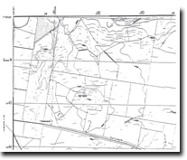
373100S 1443900E; 7822-4-1 (Sunbury) 918453. 6 km SE of Gisborne. Dalrymple Road. | 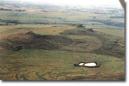 Red Rock (Gisborne) | |
Bulla. | ||
Private land. | Grazing, outcrop. | |
Type 9: | Composite lava and scoria volcano. | |
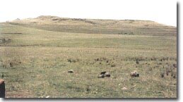
Red Rock is a flat-topped volcano surrounded by rocky escarpments apart from the eastern slope which descends gently to the surrounding lava plain. The flat capping resembles a lava disc overlying a scoria mound. Red scoria is exposed in small quarry cuts beneath the west-facing escarpment. | ||
490+ m; 45 m. | ||
Regional: | This volcano has an unusual flattened summit and may contain a higher percentage of scoria than is typical of the composite volcanoes in the Gisborne area. | |
Class 2: | Although a large feature, its proximity to Melbourne renders it liable to small farm or residential subdivision that would cover and disguise significant volcanic features. | |
References: | Edwards, A.B. & Crawford, W. (1940). The Cainzoic volcanic rocks of the Gisborne district, Victoria. Proceedings of the Royal Society of Victoria 52, pp. 281-311. | |
 Red Rock (Gisborne) | ||

© State of Victoria (Agriculture Victoria) 1996 - .

This work, Victorian Resources Online, is licensed under a Creative Commons Attribution 4.0 licence. You are free to re-use the work under that licence, on the condition that you credit the State of Victoria (Agriculture Victoria) as author, indicate if changes were made and comply with the other licence terms.
The licence does not apply to ‘branding’ or some ‘images or photographs’ that may be owned by third parties. We ask you to seek prior approval to use images using the VRO feedback form. Access to higher quality images can also be provided on request.
This page was last updated on .