
47. Yaringa - Mangrove Sedimentation
|
This information has been developed from one or more of these publications:
|
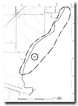
Location: | Tyabb – 465645 to 442612. Coastal area extending from Yaringa boat harbour south to 1.5 kilometres south of Denham Road. | 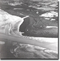 Intertidal flats, mangrove and salt marsh south from Yaringa, Site 47 |
Access: | Iluka Road, Whitneys Road, and Denhams Road. | |
Ownership: | Crown Land and private land. | |
Geology/Geomorphology: | The coastline is low and inclines a broad salt marsh zone with mangrove fringe of variable width and continuity. Several studies have attempted to determine the role of mangroves as agents of coastal sedimentation, and monitoring sites have been established near Yaringa and at Denhams Road, (Bird and Barson, 1975; Bird, 1980). South of Denhams Road, the mangrove fringe experienced severe die-back during the re-establishment. In front of the mangroves is a wide and predominantly muddy intertidal flat with poorly developed tidal channels. | |
Significance: | State. This is a major site for the study of the role of mangroves in coastal sedimentation. The area of the south Dedham Road is of particular significance for the study of the causes and rates of mangrove die-back and regeneration, and the relationship of this to sediment transport and accumulation in the intertidal zone. | |
Management: | Class 1. Further land reclamation north of Long Point should be prohibited as this will seriously interfere with the value of the site as one for monitoring long-term rates of mangrove sedimentation. | |
References: | Bird, E.C.F. and Barson, M.M. (1975). Shoreline changes in Westernport Bay. Proc. Roy. Soc. Vict. 87 (1) 15-28. Bird, J.F. (1981). Geomorphological implications of flood control measures, Lang Lang River, Victoria. Aust. Geog. Stud. 169-183. | |
 Site 47, Mangroves and coastal sediments south of Yaringa |

© State of Victoria (Agriculture Victoria) 1996 - .

This work, Victorian Resources Online, is licensed under a Creative Commons Attribution 4.0 licence. You are free to re-use the work under that licence, on the condition that you credit the State of Victoria (Agriculture Victoria) as author, indicate if changes were made and comply with the other licence terms.
The licence does not apply to ‘branding’ or some ‘images or photographs’ that may be owned by third parties. We ask you to seek prior approval to use images using the VRO feedback form. Access to higher quality images can also be provided on request.
This page was last updated on .