
91. Yallock Creek - Swamp Sediments
|
This information has been developed from one or more of these publications:
|
Location: | Tooradin – 672673. Four kilometres south of Koo-Wee-Rup. | 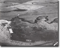 Terraces and eroding coast at mouth of Yallock Creek, Site 91 |
Access: | South Gippsland Highway and private roads. | |
Ownership: | Private land and Crown Land. | |
Geology/Geomorphology: | The lower course of the Yallock Creek was one of the few defined drainage channels existing prior to the drainage of the Koo-Wee-Rup and Tobin Yallock swamps. The creek issued from the southern end of the Koo-Wee-Rup Swamp, and was essentially the lower course of the Bunyip River which entered the swamp in the north-east. The flow of the creek was successively diverted into drains, beginning with the Nine Foot Yallock Drain in 1870. This and other drains have effectively reduced the Yallock Creek to a tidal and flood overflow channel. The abandoned channel occupies a meandering trench with three remnant terrace levels discernible. South of the creek mouth is a small network of branching tidal creeks that probably occupy an old outlet of the creek. In the absence of a mangrove fringe and with only intermittent beaches, the shoreline south from the Yallock Creek is an eroding cliff averaging 1.0 to 2.0 metres high. This provides a series of cross-sections into the sediments of the former Tobin Yallock Swamp. Those exposed near the mouth are dark grey clays and sandy clays – the absence of peat indicating this was the swamp margin (Miles, 1976). | |
Significance: | National. The site includes one of the few remnants of the landscape of the great swamp areas that existed to the north-east of Westernport Bay. It illustrates the hydrological and topographical distinctiveness of the area between the Tobin Yallock and Koo-Wee-Rup swamps. The outcrops in the coastal cliffs are of particular interest to display the phases of wetland sediment accumulation. | |
Management: | Class 1. No reclamation or further drainage or construction works should be permitted in the area of the site. Works that would alter the form and dimension of the channel of the Yallock Creek should be prohibited. | |
References: | Key, L.M. (1967). Historical geography of the Kooweerup District. M.A. thesis (unpub.) Dept. of Geog. Univ of Melb. Miles, I.W. (1976). The morphology of northern Westernport Bay. M.Sc. thesis (unpub.) Dept. of Geog. Univ. of Melb. | |
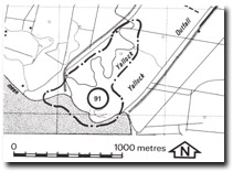 Site 91, Mouth of Yallock Creek |

© State of Victoria (Agriculture Victoria) 1996 - .

This work, Victorian Resources Online, is licensed under a Creative Commons Attribution 4.0 licence. You are free to re-use the work under that licence, on the condition that you credit the State of Victoria (Agriculture Victoria) as author, indicate if changes were made and comply with the other licence terms.
The licence does not apply to ‘branding’ or some ‘images or photographs’ that may be owned by third parties. We ask you to seek prior approval to use images using the VRO feedback form. Access to higher quality images can also be provided on request.
This page was last updated on .