
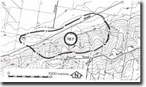
167. Woolamai - Bass Fault
|
This information has been developed from one or more of these publications:
|
Location: | Kilcunda – 665357. 3 km south-west of Woolamai near the unused railway line. | |
Access: | Staffer Road. | |
Ownership: | Private land. | |
Geology/Geomorphology: | The site includes the scarp and downwash fans of the Bass Fault northeast of Anderson. It includes an abandoned gravel pit, that is being used as a farm tip, that provides an exposure of steeply dipping gravel and coarse sand beds overlying Mesozoic sandstones. The beds are strongly indurated and their dip indicates they are not fan deposits but are beds of the Baxter Formation. The scarp of the Bass Fault is very distinctive and rises abruptly above the terraces of the Bass River floodplain. | |
Significance: | State. The site is of importance for distinguishing between alluvial fan gravels that lie on and at the foot of the Bass Scarp, and Baxter formation gravels that have been displaced and warped along the fault. This is one of the best exposures of these dipping beds. | |
Management: | Class 1. The site should not be reclaimed or filled as this would obscure the small area of outcrop available. The use of the old quarry as a rubbish pit should be prohibited and existing rubbish removed. | |
References: | Jenkin, J.J. (1962). The geology and underground water resources of the Tooradin area. Dept. of Mines, Vict. Underground Water Investigation Report No. 5 Power. (1971). Spencer-Jones, D., Marsden, M.A.H., Barton, C.M. & Carrillo-Rivera, J.J. (1975). Geology of the Westernport sunkland. Proc. Roy. Soc. Vict. (87) 1&2, 43-683 | |
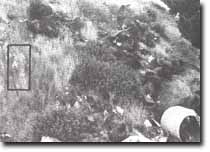 The degradation of former quarry sites displaying significant features is illustrated by Site 167 | 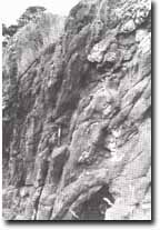 Steeply dipping Baxter Formation gravels in the trace of the Bass Fault, Site 167 |

© State of Victoria (Agriculture Victoria) 1996 - .

This work, Victorian Resources Online, is licensed under a Creative Commons Attribution 4.0 licence. You are free to re-use the work under that licence, on the condition that you credit the State of Victoria (Agriculture Victoria) as author, indicate if changes were made and comply with the other licence terms.
The licence does not apply to ‘branding’ or some ‘images or photographs’ that may be owned by third parties. We ask you to seek prior approval to use images using the VRO feedback form. Access to higher quality images can also be provided on request.
This page was last updated on .