
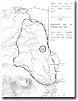
110. Western Port - Tidal Watershed
|
This information has been developed from one or more of these publications:
|
| Location: | Palmer – 670600. North-eastern Westernport Bay between Palmer Point (French Island) and the Lang Lang River mouth. | |
Access: | Access is only possible by boat at high tide. | |
Ownership: | Crown land. | |
Geology/Geomorphology: | Two principal tidal drainage systems occur in Westernport Bay. In terms of volume, the major system is to the west and north of French Island, and the second lesser arm is to the south and east of French Island. The two systems have their ebb tidal headwaters to the north-east of French Island, between Palmer Point and north of the Lang Lang River. There is a broad area of intertidal mudflat and sandflat exposed here at low tide, the surface being incised by an intricate network of ebb and flood tidal channels. The area is known as the tidal divide or tidal watershed, but the flow of water is complex and it is difficult to determine a single line that separates the two tidal systems. The configuration of the north-westerly draining system differs markedly from that draining to the south. The details of stratigraphy of the bay floor sediments, topography and tidal drainage and current patterns have been studied in detail by Miles (1974, 1976). The materials exposed in the deeply incised channels include freshwater peats and organic muds that are indicative of a former extension of the Koo Wee Rup Swamp during lower sea levels. | |
Significance: | International. This is a major tidal divide system. It is one of the most intensively investigated tidal watershed systems on the Australian coast and is of a size and complexity that warrants inclusion on an international register of such features. The dynamics of the area play a critical role in determining the nature of tidal flow in other parts of Westernport Bay. The sea floor sediments here are of considerable interest for the data they hold concerning the development of the on-shore swamplands, and for the history they record of late Quaternary sea level changes in northern Westernport Bay. | |
Management: | Class 1. No major engineering works, either on the adjacent coasts or in Western Port, should be permitted if they interfere with the form, dynamics, and sedimentation of the tidal divide area. No dredging or dumping of dredge spoil should be permitted in the area, or in adjacent areas where current flow would bring this onto the tidal watershed. Clearly defined high water navigation channels should be marked across the tidal divide. This will reduce the bottom scouring by boat propellers that is currently taking place and is changing the form and dimension of some of the channels. | |
References: | Miles, I.W. (1974). The morphodynamica of interdial channels on the tidal watershed of Westernport Bay. B.Sc. Hons. thesis (Unpub.) Dept. of Geog. Univ. of Melb. Miles, I.W. (1976). The morphology of northern Westernport Bay. M.Sc. thesis. (Unpub.) Dept. of Geog. Univ. of Melb. Marsden, M.A.H. & Mallett, C.W. (1975). Quaternary evolution, morphology, sediments and environments, Westernport, Victoria. Proc. Roy. Soc. Vict. Vol. 87 (1) 107-137. | |
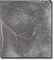 Incised tidal channels at the Head of the North Arm tidal channel system on the tidal watershed of Westernport Bay. White dots are one metre square marker boards, the "V" shape is formed by two kayaks on the mudflat. Darker patches are sea grass, straight lines are channels scoured by boat propellers. Ripples in channels are rapids at ebb tide at knickpoints formed where the channels intersect a shell bed overlying freshwater swamp deposits. Site 110. | 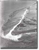 The multiple recurving spits that comprise Stockyard Point. Also shown are Lang Lang delta (A), tidal watershed (B), Red Bluff (C), part of Pioneer Bay (D). Sites 110 to 115. |

© State of Victoria (Agriculture Victoria) 1996 - .

This work, Victorian Resources Online, is licensed under a Creative Commons Attribution 4.0 licence. You are free to re-use the work under that licence, on the condition that you credit the State of Victoria (Agriculture Victoria) as author, indicate if changes were made and comply with the other licence terms.
The licence does not apply to ‘branding’ or some ‘images or photographs’ that may be owned by third parties. We ask you to seek prior approval to use images using the VRO feedback form. Access to higher quality images can also be provided on request.
This page was last updated on .