
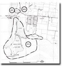
210. Tortoise Head
|
This information has been developed from one or more of these publications:
|
Location: | Rhyll - 490480. The site extends south from Tea Tree Point. | |
Access: | A narrow walking trail leads to Tortoise Head from the Tankerton Jetty along the western margin of the mangrove/salt marsh zone which separates Tortoise Head from the main island. | |
Ownership: | Commonwealth and Crown land. | |
Geology/Geomorphology: | Tortoise Head is a large promontory of basalt at the south-western corner of French Island. It was formerly separated from French Island by a narrow tidal channel but this channel has been closed by the northward growth of a spit and further narrowed by mangrove growth. Tortoise Head is composed of a layered sequence of Older Volcanics exposed in extensive cliff sections, consisting of deeply weathered basalts, basaltic clay and agglomerates. The sequence is capped by a small remnant of Upper Tertiary coarse grained sandstone inferred to be part of the Baxter Formation. | |
| The shoreline of Tortoise Head is varied, ranging from a high wave energy shore platform along its southern margin, to cobble beaches alternating with sandy beaches overlying wide shore platforms along the western margin. At the base of bluffs on the eastern side, a low terrace isolated from marine activity by its slight elevation above present sea level, may indicate a former shore platform in an area which is now covered by salt marsh and mangrove sediments. A well developed cuspate foreland has formed on the leeward side of a small basalt island off the western shoreline of the Head. The base of Tortoise Head is composed of solid basalt which is exposed in shore platforms around the southern and western margin. The Oversteepened cliffs of the southern section are actively undercut by marine erosion. This erosion, in combination with slope failure, has resulted in a number of large landslides which are indicated by cliff-top scars below which are fans of slumped material. Overgrazing has denuded much of the vegetation cover of the westerly facing cliffs further contributing to their instability. | ||
Significance: | State. Tortoise Head offers an excellent opportunity for the continued study of a large number of the geomorphic processes operating in Westernport Bay, in particular, the role played by mangrove advance in the initiation of salt marsh formation. Bird and Barson (1975), have identified Tortoise Head as one of the few areas of continuing mangrove advance. Physiographic changes in the area to the north of Tortoise Head such as sedimentation of tidal channels, spit growth, mangrove advance, salt marsh formation and changes in shoreline features have been well documented in successive series of aerial photographs since 1939. | |
The vertical thickness of Eocene volcanics exposed at Tortoise Head may represent a particularly important site in the study of the Lower Tertiary volcanic sequence of the Westernport Catchment. | ||
Management: | Class 1. In order to preserve the diversity of geological and geomorphological features, it is strongly recommended that no quarrying be permitted at Tortoise Head. Coastal engineering works should not be undertaken south of the Tankerton Jetty. Because of the inevitability of slope retreat on the Over steepened basalt cliffs of the Head it is recommended that no constructions be permitted in this potentially hazardous area, either along the upper surface of the Head or along the base of the cliffs. | |

© State of Victoria (Agriculture Victoria) 1996 - .

This work, Victorian Resources Online, is licensed under a Creative Commons Attribution 4.0 licence. You are free to re-use the work under that licence, on the condition that you credit the State of Victoria (Agriculture Victoria) as author, indicate if changes were made and comply with the other licence terms.
The licence does not apply to ‘branding’ or some ‘images or photographs’ that may be owned by third parties. We ask you to seek prior approval to use images using the VRO feedback form. Access to higher quality images can also be provided on request.
This page was last updated on .