
189. Swan Lake - Tombolo and Dunes
|
This information has been developed from one or more of these publications:
|
Location: | Pyramid Rock – 390360. 1 km west of Summerland. | |
Access: | Walking track from Ventnor Road. | |
Ownership: | Crown land and private land. | |
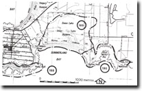
Geology/Geomorphology: | The area between Cat Bay and Summerland Bay is a double tombolo formation that links the former Summerland’s Island to the main body of Phillip Island. The tombolo base has been built upward by the growth of beach ridges and transgressive dunes from both the northern (Western Port) and southern (Bass Strait) shores. These sand bodies have not coalesced however and they enclose a swampy lowland including the open water area of Swan Lake. This site includes part of the wetland and the dunes of the southern tombolo. | |
Significance: | State. This is the best example of double tombolo formation on the Victorian coast. Stages in the reclamation of the former seaway may be determined by a study of the dune and wetland systems. | |
Management: | Class 2. Intensive subdivision or sand extraction on the dune area should not be permitted. Swan Lake and its adjacent swampland should not be converted into an artificial waterway, although some modifications consistent with wildlife management could be undertaken without seriously diminishing the significance of the site. | |
References: | Edwards, A.B. (1945). The geology of Phillip Island. Ibid. 57 (1+2) 1-21. Jenkin, J.J. (1962). The geology and hydrogeology of the Westernport area. Dept. of Mines, Vict. Underground Water Investigation Report. No. 5 | |

© State of Victoria (Agriculture Victoria) 1996 - .

This work, Victorian Resources Online, is licensed under a Creative Commons Attribution 4.0 licence. You are free to re-use the work under that licence, on the condition that you credit the State of Victoria (Agriculture Victoria) as author, indicate if changes were made and comply with the other licence terms.
The licence does not apply to ‘branding’ or some ‘images or photographs’ that may be owned by third parties. We ask you to seek prior approval to use images using the VRO feedback form. Access to higher quality images can also be provided on request.
This page was last updated on .