
7 Swan Island - Sand Accretion
|
This information has been developed from one or more of these publications:
|
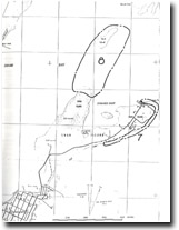
| Location | 980637 to 986647. Eastern and northern shores of Swan Island. | 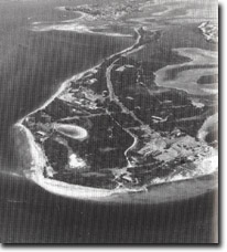 Site 7, Swan Island, beach ridges and spits during an erosion phase (March 1988) |
Access | Bridge Street, Queenscliff. | |
Ownership/Managing Authority | Commonwealth Land (Department of Defence). [Public access is not permitted and this site has not been evaluated in the field. The assessment is prepared from available reports and aerial photograph interpretation.] | |
Site Description | Swan Island is a depositional island consisting of parallel and converging sand ridges enclosing lagoons and saline marshes. There are broad sandy and muddy tidal flats on the western (Swan Bay) side, with beaches and beach ridges more prominent on the east and north. The island has been built by accumulation of sand carried through Port Phillip Heads by waves and tidal currents. The tidal currents, which average about 1 km/hr, are a constant factor in sediment movement and allow sediment to be steadily moved northward. In shallower water, wave action forms bars and shapes the sand deposits into beaches and beach ridges. Analysis of historical records show several episodes of advance and retreat of beaches and beach ridges along the eastern and northern shore of the island, with shoreline displacement of up to 300 m over one 15 year period (1961-1976). In 1910, a broad zone of grassy beach ridges was present adjacent to Swan Beacon on the central east coast, but by 1923 this has been eroded and the sand moved northward causing progradation of the northern coast of the island. Other substantial changes were noted between 1949 and 1961, and 1964 and 1976. Such rapid and substantial changes are possibly due to occasional large injections of sand (‘slugs’) that move through Port Phillip Heads and migrate onshore to the central sector of the east coast of Swan Island where they are built as a broad area of beach ridges or low dunes. When the sand ‘slug’ has been exhausted, erosion will predominate and the eroded material forms another lobate foreland or a curving spit on the northeastern and northern shores of the island. | |
Since the construction of the Queenscliff breakwater, which has obstructed the northward drift of sand from Port Phillip Heads, erosion has been dominant on Swan Island apart from minor accretion south of Swan Beacon and on the northeast point. | ||
Significance | Regional. Swan Island is a major emerged sand accumulation feature in Port Phillip Bay and its development has determined the pattern of sedimentation in Swan Bay. The dynamics of the eastern shore outlined above are of particular interest in assessing the sand budget of the Bay and in determining the movement of sand through the Heads. The site also provides an opportunity to observe the development of wave dominated sand ridges with little input of wind-blown sand. | |
Management Considerations | Class 2. Establishment of permanent monitoring profiles would assist in understanding the mechanism of ridge formation and sand accumulation here. To maintain the long term equilibrium of sand supply, it is necessary for more of the dredge spoil taken from the Queenscliff harbour entrance to be pumped north to nourish those beaches deprived of sand ‘slug’ injection due to diversion or trapping behind the harbour walls. The use of rubble or boulder groynes as a means of shoreline stabilization should be discontinued. | |
References | Riedel, H.P. & Fidge, B.L. (1977). | |
Site 7 & 8, Swan Island and Duck Island/Point Norgate

© State of Victoria (Agriculture Victoria) 1996 - .

This work, Victorian Resources Online, is licensed under a Creative Commons Attribution 4.0 licence. You are free to re-use the work under that licence, on the condition that you credit the State of Victoria (Agriculture Victoria) as author, indicate if changes were made and comply with the other licence terms.
The licence does not apply to ‘branding’ or some ‘images or photographs’ that may be owned by third parties. We ask you to seek prior approval to use images using the VRO feedback form. Access to higher quality images can also be provided on request.
This page was last updated on .