
PP71. Sunnyside Beach - Mesozoic Sediments
|
This information has been developed from one or more of these publications:
|
| Location: | 303701. Small point at the south end of Sunnyside Beach, Mt Eliza, and shore platform outcrops extending 200 m north of the point. | 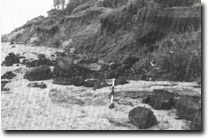 Site 71 Sub-basaltic sediments at Sunnyside Beach. |
Access: | Sunnyside Road, Mt Eliza. | |
Ownership/Managing Authority: | Crown land below high water mark, private land. | |
Site Description: | The site has complex geology, most of which is only visible at low tide when the shore platform is exposed. The outcrops being at, and extend offshore and north from, the rocky point about 100 m north of the car park at the western end of Sunnyside Road. The point consists of weathered basalt (Older Volcanics) and sub-basaltic sediments adjacent to a small outcrop of Mesozoic (Lower Cretaceous) sandstone, although the contract is obscured. The Cretaceous forms much of the shore platform extending 200 m north of the point. At the high tide line, a seam of brown coal is exposed to the north by weathered volcanics. Less weathered volcanics occur further north. | |
Significance: | State. The site is a significant interpretation site to determine the structures and stratigraphic sequence on the northern side of the Mt Eliza Granodiorite. The relationships of the Mesozoic, basalt and lignite presents one of the most challenging advanced geological mapping projects on Port Phillip Bay. The site is the most extensive exposure of Mesozoic sediments in Port Phillip Bay, these rocks outcropping only in the Sunnyside Beach area. The faults are related to movements of the Selwyn Fault system, the major tectonic structure of Port Phillip Bay. Further research to determine the age and stratigraphic relationships of the rocks is being undertaken by Monash University. | |
Management Considerations: | Class 1. The cliff and shore platform exposures should be left as geological features. Because the most significant exposures occur on the shore platform, (and are still a few centimeters under water at all but the lowest tides), their existence is not readily obvious. It is therefore important that no beach nourishment, boulder groynes or walls, or other offshore works that would cover the platform should be undertaken. Public access to the site should be available to all people at all times, regardless of their state of dress, and signposting to that effect should be displayed. This is not private beach. | |
References: | Gostin, V.A. (1966). Tertiary stratigraphy of the Mornington district, Victoria. Proc. R. Soc. Vict., 79. 459-512. | |
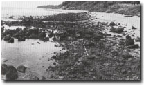 Site 71. Cretaceous sediments covered by ferruginous Baxter Formation gravels, Sunnyside Beach. | 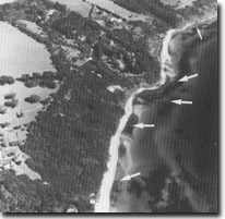 Sites 71, 71, 72. Arrows show significant outcrops that occur in the intertidal zone and are exposed only during very low tides. |

© State of Victoria (Agriculture Victoria) 1996 - .

This work, Victorian Resources Online, is licensed under a Creative Commons Attribution 4.0 licence. You are free to re-use the work under that licence, on the condition that you credit the State of Victoria (Agriculture Victoria) as author, indicate if changes were made and comply with the other licence terms.
The licence does not apply to ‘branding’ or some ‘images or photographs’ that may be owned by third parties. We ask you to seek prior approval to use images using the VRO feedback form. Access to higher quality images can also be provided on request.
This page was last updated on .