
55. Sandy Point - Silurian and Tertiary Outcrops
|
This information has been developed from one or more of these publications:
|
Location: | Somers – 425480 to 460470. The southern section of the RAN Flinders Naval Depot. |
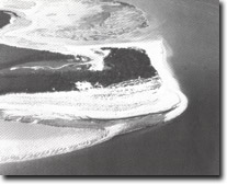 Recurving sand spit, beach ridges, tidal inlet and sand ripples, Sandy Point, Site 55. |
| Access: | The area is closed to the public and permission for entry must be obtained from the appropriate officer at the Naval Depot. | |
| Ownership: | Commonwealth Government land (RAN Flinders Naval Depot). | |
| Geomorphology: | The site includes a complex series of sand beach ridges that extend for over four kilometres east from the base of the coastal bluff as Western Hill. Although basically parallel, the ridges are gently curving and in places shore convergence and truncation. To the east the ridges terminate in the recurved spit of Sandy Point. | |
| Significance: | State. The ridges represent one of the largest spit systems on the Victorian coast and are the least disturbed sandy coastal area on the mainland shores of Western Port. They are of particular significance for the display of coastal vegetation on sand beach ridges including Spinifex hirsutus, Acacia longifolia, Leprospermum laevigatum, and Banksia integrifolia (Barson and Calder, 1976). The dynamics of accretion and erosion on the southern shoreline resulting in formation of new ridges is of particular interest. The site is the most rapidly changing shoreline in Western Port and one of the most dynamic on the Victorian coast. The area of significance includes the sandy bars and shoals in the nearshore zone. | |
| Management: | Class 1. Clearing of the area and levelling of the ridge system should be prohibited. | |
References: | Barson and Calder (1976). Jenkin, J.J. (1962). The geology and hydrogeology of the Westernport area. Dept. of Mines Vict. Underground Water Investgation Report No. 5. | |
 The depositional complex of Sandy Point extending eastward from the bluff at Somers, Sites 53,55 and 56 | 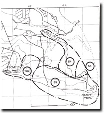 Site 55, Sandy Point area |
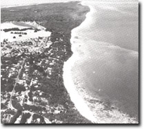
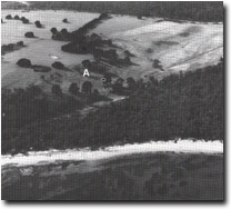 Bluff (A) and older beach ridges at the proximal end of the Sandy Point spit, Site 56. |

© State of Victoria (Agriculture Victoria) 1996 - .

This work, Victorian Resources Online, is licensed under a Creative Commons Attribution 4.0 licence. You are free to re-use the work under that licence, on the condition that you credit the State of Victoria (Agriculture Victoria) as author, indicate if changes were made and comply with the other licence terms.
The licence does not apply to ‘branding’ or some ‘images or photographs’ that may be owned by third parties. We ask you to seek prior approval to use images using the VRO feedback form. Access to higher quality images can also be provided on request.
This page was last updated on .