
48. Sandstone Island - Silurian Outcrop
|
This information has been developed from one or more of these publications:
|
Location: | Tyabb – 4374560. Approximately 600 metres north-east of Jacks Beach. | 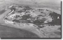 Sandstone Island. Main mangrove area (A) and steeply dipping Silurian sediments (B) |
Access: | Access is only possible by boat even at low tide. Landings may readily be made at several points on the island. | |
Ownership: | Sandstone Island is an outcrop of Silurian sandstone and mudstone beds folded into an anticline with a steep southerly plunge. The strata are best displayed in out crops as shore platforms on all sides of the island. Sandstone island has a broad gently undulating surface up to 14 metres above the sea level and is bordered by steep, grassy coastal bluffs up to five metres high. The bluffs display landslip scars and terraces, and there are small cliffed sectors on the eastern and western side exposing bedding planes in the Silurian rocks. Mangroves are extensive on the sheltered north-western shore but elsewhere they occur only in small patches. | |
Geology/Geomorphology: | State. The island is a major exposure of Silurian strata and one of the few coastal outcrops of this material in the state. | |
Significance: | Class 2. The principal geological interest in the island is the outcrops in the coastal cliffs and platforms, especially on the southern half of the island. Covering of these by coastal engineering or harbour works should not be permitted. | |
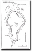 Sandstone Island morphological map showing structure of Silurian outcrops, Site 48 |

© State of Victoria (Agriculture Victoria) 1996 - .

This work, Victorian Resources Online, is licensed under a Creative Commons Attribution 4.0 licence. You are free to re-use the work under that licence, on the condition that you credit the State of Victoria (Agriculture Victoria) as author, indicate if changes were made and comply with the other licence terms.
The licence does not apply to ‘branding’ or some ‘images or photographs’ that may be owned by third parties. We ask you to seek prior approval to use images using the VRO feedback form. Access to higher quality images can also be provided on request.
This page was last updated on .