
168. San Remo Peninsula - North Shore
|
This information has been developed from one or more of these publications:
|
Location: | Kilcunda – 595352 to 622360. North shore of the San Remo Peninsula east of Black Beach Road. | 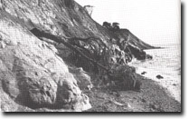 Bluffs and shore platform on northern side of San Remo Peninsula. Mesozoic outcrops and contact with Older olcanics are arrowed, Site 168 |
Access: | Coastal walk from San Remo. | |
Ownership: | Private land above high water mark. | |
Geology/Geomorphology: | The northern coast of the San Remo Peninsula is a high coast formed in Older Volcanics basalt with inliers of Mesozoic sediments. The Mesozoics include beds of grit derived from erosion of the Woolamai granite. Cliffed sectors are most pronounced towards the east where they are cut in columnar jointed Older Volcanics basalt. The bluff profiles are straight or irregular where there are occasional small soil slumps. The coast is fronted by a wide gently sloping shore platform which exposes the contact between Mesozoic sediments and Older Volcanics basalt at several places at low tide. A veneer of pebbles covers most of this platform, and accumulations of pebbles and sand lie above high water mark at the base of most of the bluffs. Pebbles also lie above reach of wave action (1.5 m) in the valley of a small creek. | |
Significance: | State. The contact between Mesozoic sediments and the basalt is well exposed and the grit beds are uncommon. This coast is distinctive for the width of the shore platform and the evidence of recent abandonment of the sea of the base of the bluffs. The coastal profiles contrast markedly with those in similar lithologies on the ocean coast of the peninsula. | |
Management: | Class 2. Residential or other construction development on the coastal slopes below the crest of the cliffs and bluffs should not be permitted. Private property coastal pathways and boat launching facilities could be permitted, but large scale schemes that involved covering extensive areas of the platform or the abandoned beach deposits should be prohibited. | |
References: | Stirling, J. (1893). Topographical and geological survey of Gippsland Carbonaceous area. Spec. Rept. Coalfields, Vict. No. 2. Edwards, A.B. (1941). The San Remo Peninsula. Ibid. 54 (1) 336-341. O’Brien, P.E. (1976). The Mesozoic fluviatile sediments of the San Remo Peninsula. B.Sc. Hons. thesis. (Unpub.) Dept. of Geol. Univ. of Melb. | |
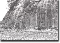 Jointed basalt forming an active coastal cliff, north shore of San Remo Peninsula, Site 168. | 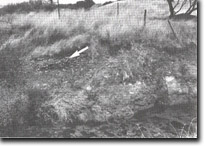 Beach gravels (arrowed) 1.5 m above high water mark overlying Mesozoic rocks, Site 168 |

© State of Victoria (Agriculture Victoria) 1996 - .

This work, Victorian Resources Online, is licensed under a Creative Commons Attribution 4.0 licence. You are free to re-use the work under that licence, on the condition that you credit the State of Victoria (Agriculture Victoria) as author, indicate if changes were made and comply with the other licence terms.
The licence does not apply to ‘branding’ or some ‘images or photographs’ that may be owned by third parties. We ask you to seek prior approval to use images using the VRO feedback form. Access to higher quality images can also be provided on request.
This page was last updated on .