
81. Rutherford Inlet - Warneet Beds
|
This information has been developed from one or more of these publications:
|
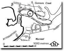
| Location: | Devon Meadows – 527686. The shoreline of Rutherford Inlet at the town of Warneet on both sides of the channel. | 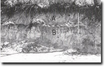 Unconformity between Cranbourne Sand (A) and Warneet Beds (B), Rutherford Inlet, Site 81 |
Access: | Cannons Creek Road, Irene Parade, Rutherford Parade. | |
Ownership: | Crown Land. | |
Geology/Geomorphology: | The cliffs bordering Rutherford Inlet are two to four metres high, and display geological sections of the unconformity between the Warneet Beds and the overlying Cranbourne Sands. | |
Significance: | State. The site affords the best exposure of the beds classified by Jenkin (1962) as the Warneet Beds. Because the age and origin of these beds is uncertain, (Cass 1973, Thompson 1974, Spencer –Jones et al 1975), it is essential that this section be retained as a teaching and research locality. | |
| Management: | Class 1. Preservation of extensive lateral and vertical sections of the beds is desirable. No artificial shore protection structures at the base of the cliffs should be permitted as these would obscure important parts of the section. Pedestrian access should be controlled to avoid traffic down the cliff face as this causes slumping in the unconsolidated Cranbourne Sands. | |
References: | Jenkin, J.J. (1962). The geology and hydrogeology of the Westernport area. Dept. of Mines, Vict. Underground Water Investigation Report. No. 5. Cass, M.R. (1973). The geology of the Tyabb and Koo-Wee-Rup sections of the Targo-Westernport pipeline. B.Sc. (Hons.) thesis, Geol. Dept., Univ. of Melb. Thompson, B.R. (1974). The geology and hydrogeology of the Westernport sunklands. Geol. Surv. Report. 1974/1. Spencer-Jones, D., Marsden, M.A.H., Barton, C.M. & Carrillo-Rivera, J.J. (1975). Geology of the Westernport sunkland. Proc. Roy. Soc. Vict. (87) (1&2), 43-68. | |
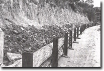 Shore protection schemes such as this obscure geologically significant sections at Rutherford Inlet, Site 81. |

© State of Victoria (Agriculture Victoria) 1996 - .

This work, Victorian Resources Online, is licensed under a Creative Commons Attribution 4.0 licence. You are free to re-use the work under that licence, on the condition that you credit the State of Victoria (Agriculture Victoria) as author, indicate if changes were made and comply with the other licence terms.
The licence does not apply to ‘branding’ or some ‘images or photographs’ that may be owned by third parties. We ask you to seek prior approval to use images using the VRO feedback form. Access to higher quality images can also be provided on request.
This page was last updated on .