
177. Rhyll Quarry - Rhyll Arkose
|
This information has been developed from one or more of these publications:
|
Location: | Rhyll – 512417. Southern side of Rhyll Inlet, 1 km north-east of Rhyll. | 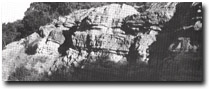 Beds of Rhyll Arkose, Rhyll quarry, Site 177 |
| Access: | Walk around the cliff top to the west from the end of the road overlooking Rhyll Inlet. | |
| Ownership: | Crown land. | |
| Geology: | The abandoned quarry face exposes a 10 m high section of feldspathic grits and arkose with some thin mudstone beds (Edwards 1945). Fragments of plant fossils have established the age of the beds as Lower Cretaceous (Medwell 1954). The beds are gently folded and show a generally southerly dip. Because of lithological differences compared with other Mesozoic rocks in the Westernport catchments (the absence of volcanic fragments and low feldspar content), Jenkin (1962) proposed that the beds are given formation status as the Rhyll Arkose. | |
| Significance: | State. The site includes the only known Mesozoic outcrop known on Phillip Island. The beds represent the only lithological subdivision to be made to formation level of the Mesozoic rocks in the Gippsland basin. | |
| Management: | Class 2. Any activity that would obscure or degrade the exposures in the quarry eg – artificial fill or dumping of rubbish, should be prohibited. | |
| References: | Blandowsk.i (1857). Edwards, A.B. (1945). The geology of Phillip Island. Ibid. 57 (1+2) 1-21. Medwell, L.M. (1954). A review and revision of the flora of the Victorian Lower Jurassic. Proc. Roy. Soc. Vict. 65 (2). 6-11. Jenkin, J.J. (1962). The geology and hydrogeology of the Westernport area. Dept. of Mines Vict. Underground Water Investgation Report No. 5. O’Brien, P.E. (1976). The Mesozoic fluviatile sediments of the San Remo Peninsula. B.Sc.Hons. thesis (unpub.), Dept. of Melb. | |
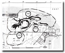 Sites 177 to 179, Rhyll Inlet area |

© State of Victoria (Agriculture Victoria) 1996 - .

This work, Victorian Resources Online, is licensed under a Creative Commons Attribution 4.0 licence. You are free to re-use the work under that licence, on the condition that you credit the State of Victoria (Agriculture Victoria) as author, indicate if changes were made and comply with the other licence terms.
The licence does not apply to ‘branding’ or some ‘images or photographs’ that may be owned by third parties. We ask you to seek prior approval to use images using the VRO feedback form. Access to higher quality images can also be provided on request.
This page was last updated on .