
141. Reef Island and Kennedy Point
|
This information has been developed from one or more of these publications:
|
Location: | Corinella – 605408 to 623405. 5 km north-west of Bass. | 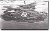 Reef Island (foreground) is linked to Kennedy Point at low tide by a series of gravelly ridges (arrowed) Site 141. |
| Access: | Soldiers Road and Bluff Road. | |
| Ownership: | Crown land. | |
| Geology/Geomorphology: | Kennedy Point (formerly Stony Point) is a low tapering promontory fringed by beaches of coarse angular fragments of ferruginized basalt and sandstone. The area is a complex mosaic of lagoons, salt marsh, mangroves, and sand and gravel ridges in places covered by a silty mud. Several gravelly ridges extend seaward from Kennedy Point and a broad ridge of this material Links Reef Island and the point at low tide. The point and Reef Island consist of a basement of Older Volcanics basalt overlain by a veneer of Tertiary clayey gravels, sandy gravels and sands. Minor faulting noted at Reef Island indicates a possible extension of the Heath Hill Fault. At two localities in the site, a poorly preserved marine fossil fauna of gastropods, bivalves, and an occasional solitary coral suggest an Early to Middle Miocene age for the sediments (Spencer-Jones et al. 1975). North of Kennedy Point there is a low and degraded coastal bluff fronted by beach ridges. | |
| Significance: | State. This is a very unusual coastal configuration and the reasons for the accumulation of the gravel fragments in such quantities are not clear. The outcrops and the minor faulting noted above are of importance in determining the extent of the Miocene marine depositional basin in the Westernport region. | |
| Management: | Class 1. Quarrying or removal of the beach and bar gravels should be prohibited. No coastal protection works or any building construction works should be permitted in the site. | |
| References: | Jenkin, J.J. (1962). The geology and hydrogeology of the Westernport area. Dept. of Mines Vict. Underground Water Investgation Report No. 5. Power (1971). Spencer-Jones, D., Marsend, M.A.H., Barton, C.M. & Carrillo_Rivera, J.J. (1975). Geology of the Westernport sunkland. Proc. Roy. Soc. Vict. (87) 1&2, 43-68 | |
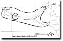 Site 141, Reef Island and Kennedy Point |

© State of Victoria (Agriculture Victoria) 1996 - .

This work, Victorian Resources Online, is licensed under a Creative Commons Attribution 4.0 licence. You are free to re-use the work under that licence, on the condition that you credit the State of Victoria (Agriculture Victoria) as author, indicate if changes were made and comply with the other licence terms.
The licence does not apply to ‘branding’ or some ‘images or photographs’ that may be owned by third parties. We ask you to seek prior approval to use images using the VRO feedback form. Access to higher quality images can also be provided on request.
This page was last updated on .