
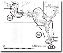
192. Redcliff Head - Tuff Beds
|
This information has been developed from one or more of these publications:
|
Location: | Pyramid Rock – 438343. 1 km south-east of the car park at Berry Beach. | |
Access: | Coastal walk from car park at Berry Beach Road. | |
Ownership: | Crown land. | |
Geology/Geomorphology: | Redcliff Head is a steep slope formed on red tuffs. Hard basalt forms a coastal cliff at the base of the slope and overlying this is 30 to 40 m of tuff and agglomerate. | |
Significance: | Regional. This is a major exposure of the tuffs of the Older Volcanics. | |
Management: | Class 2. The coastal slope is unstable and residential or recreational constructions should not be permitted adjacent to the plateau edge above Redcliff Head. | |
References: | Edwards, A.B. (1945). The geology of Phillip Island. Ibid. 57 (1+2) 1-21. | |

© State of Victoria (Agriculture Victoria) 1996 - .

This work, Victorian Resources Online, is licensed under a Creative Commons Attribution 4.0 licence. You are free to re-use the work under that licence, on the condition that you credit the State of Victoria (Agriculture Victoria) as author, indicate if changes were made and comply with the other licence terms.
The licence does not apply to ‘branding’ or some ‘images or photographs’ that may be owned by third parties. We ask you to seek prior approval to use images using the VRO feedback form. Access to higher quality images can also be provided on request.
This page was last updated on .