
PP73. Red Bluff (Mornington) - Raised Platform
|
This information has been developed from one or more of these publications:
|
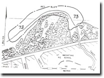
| Location: | 282685. Headland immediately west of Tanti Creek, Mornington. | 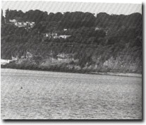 Site 73. Red Bluff, Mornington |
Access: | The Esplanade, Mornington, opposite Tanti Ave. | |
Ownership/Managing Authority: | Crown land, Shire of Mornington. | |
Site Description: | The cliff is a 10 m exposure of Baxter Sandstone, the upper terrestrial unit of the Mornington Peninsula Tertiary sedimentary formations. It is a hard, coarse-grained, cross-bedded rock, stained red and yellow and cemented by iron. There are two distinct groups of beds at this outcrop, the upper 5 m being harder, more ferruginous and darker in colour, while the lower units display strong cross-bedding. This outcrop has a gentle dip to the south. A broad scree slope has built up around the base of the cliff partly covering an irregular boulder and gravel veneered platform. Near the mouth of Tanti Creek, there is a clear exposure of a higher level platform overlain by rounded gravels and shells. The same feature appears on the south western side of Red Bluff. | |
Significance: | State. This is a very significant and accessible exposure of Baxter Sandstone and is of high importance to illustrate a higher level platform and boulder beach. It is a good site to show the cross-bedding, coarse nature, variable clay content and degrees of ferruginization of these rocks. The relative stability of this cliff compares with the landslipped and gullied coastal slopes south of Mornington. This is due to the relative hardness of the Baxter Sandstone compared to the underlying formations exposed to the south. The site has perhaps the best exposure of a raised platform and overlying beach deposits in Port Phillip Bay. It is therefore a highly significant locality for geomorphological and geological studies of coastal cliff and platform development. | |
Management Considerations: | Class 1. No cliff stabilization schemes or coast protection works (other than beach nourishment) should be undertaken. The boulder wall at the base near Tanti Creek fortuitously just avoids obscuring the raised platform. It is a spectacular example of a ‘clumsy’, hastily erected structure that is totally unsympathetic to the form of the cliff it is presumably to protect. No extension to this wall should occur. An instructive comparison may be drawn with the sea wall on the south of Red Bluff, which is an effective and harmonious structure that utilizes local rather than foreign rock materials. Cliff-top utilization should be planned to take account of the possibility of cliff recession due to rockfalls or landslips occurring. The site requires priority management as a scientific rather than a recreational site. | |
References: | Gostin, V.A. (1966). Tertiary stratigraphy of the Mornington district, Victoria. Proc. R. Soc. Vict., 79, 459-512. Hills, E.S. (1940). The question of recent emergence of the shore of Port Phillip Bay. Proc. R. Soc. Vict., 51, 112-159. | |
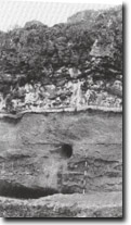 Site 73. Red Bluff, Mornington. Note cross-bedding in lower group of beds. | 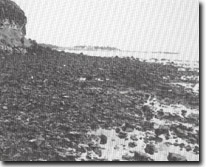 Site 73 Red Bluff, Mornington. Gravel-covered shore platform. | 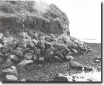 Site 73. Red Bluff, Mornington. Poorly conceived boulder wall almost obliterates the raised platform and beach (base of ranging pole). |
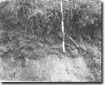 Site 73. Red Bluff, Mornington. Detail of raised platform and gravel beach. | 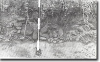 Site 73. Red Bluff, Mornington. Raised platform and gravel beach on western side of point. | 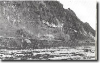 Site 73. Red Bluff, Mornington. Effective and harmonious sea wall on western side of point. |
 Site 73. Red Bluff, Mornington |

© State of Victoria (Agriculture Victoria) 1996 - .

This work, Victorian Resources Online, is licensed under a Creative Commons Attribution 4.0 licence. You are free to re-use the work under that licence, on the condition that you credit the State of Victoria (Agriculture Victoria) as author, indicate if changes were made and comply with the other licence terms.
The licence does not apply to ‘branding’ or some ‘images or photographs’ that may be owned by third parties. We ask you to seek prior approval to use images using the VRO feedback form. Access to higher quality images can also be provided on request.
This page was last updated on .