
216. Red Bluff - Mesozoic Sandstone
|
This information has been developed from one or more of these publications:
|
Location: | Rhyll 580487 to Corinella - 590488. Southern coastline extending from the western edge of Elizabeth Bay eastwards along the coast to the north of Stockyard Point. | 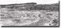 Cliffs and shore platform in Mesozoic sediments at Red Bluff, Site 216. |
Access: | Salt Mine Point Road and Mosquito Creek Road. | |
Ownership: | Crown land - Coastal Reserve | |
Geology/Geomorphology: | At Red Bluff a sequence of Mesozoic felspathic sandstone, shales, mudstones and intraformational conglomerates is exposed in an active cliff and a wide shore platform. The strata dip steeply towards the north and are intersected by several joint sets which have been infilled by ferruginous cement. Inclusions of carbonaceous lenses of plant material and siliceous plant stems (‘petrified wood’) are common throughout the outcrops. The rocks include calcareous concretions, and spheroidal weathering and honeycomb weathering is common. Water level weathering on the shore platform has resulted in the development of a series of well defined terraces which decrease in elevation towards the outer edge of the platform. At The Buttress occurs the best exposure of intraformational conglomerate observed in the French Island Mesozoic outcrops. The conglomerate consists of gravel and pebble size sub-rounded felspathic sandstone fragments cemented by a fine mudstone matrix. The presence of intraformational conglomerate in this sequence is particularly significant because it may provide evidence of the sedimentary environment existing in this section of the Westernport Sunkland during the Lower Cretaceous period. | |
Between The Buttress and Stockyard Point, wave energy is significantly reduced and the shore platform is covered by a veneer of mudflat sediments. The extent of vertical outcrop gradually decreases towards Stockyard Point where a masked contact between Tertiary basalts and Mesozoic strata occurs in the shore platform Near Stockyard Point there is a ferruginous gravel developed at the contact of the Older Volcanics and Mesozoic sediments and narrow bands of limonite occur in basaltic clay. | ||
Significance: | State. The site displays a wide variety of weathering and structural features and represents the thickest vertical exposure of Mesozoic strata on French Island. The lithological diversity of the outcrop provides an excellent type-section of the Lower Cretaceous sequence exposed in Westernport Bay. The area between Red Bluff and Salt Mine Point is of historical significance as it was described earlier in the century by the then Director of the Victorian Geological Survey (Dunn 1977). The features observed by Dunn are still clearly evident, although the outcrop of limonite referred to by him has been severely depleted by removal of the material for ship ballast, and more recently, floor tiles (C. Chandler pers. Comm.). | |
Management: | Class 2. To preserve the site it is recommended that no quarrying or removal of rock material be permitted from this site. Collection of siliceous and carbonaceous plant remains should be restricted to professional palaeontologists. | |
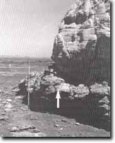 The Buttress, north of Red Bluff. Arrow indicates bed of introformational conglomerate, Site 216. | 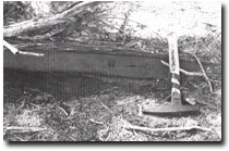 Lens of limonite contained in basaltic clay, Stockyard Point, Site 216. |

© State of Victoria (Agriculture Victoria) 1996 - .

This work, Victorian Resources Online, is licensed under a Creative Commons Attribution 4.0 licence. You are free to re-use the work under that licence, on the condition that you credit the State of Victoria (Agriculture Victoria) as author, indicate if changes were made and comply with the other licence terms.
The licence does not apply to ‘branding’ or some ‘images or photographs’ that may be owned by third parties. We ask you to seek prior approval to use images using the VRO feedback form. Access to higher quality images can also be provided on request.
This page was last updated on .