
193. Pyramid Rock - Unconformity
|
This information has been developed from one or more of these publications:
|
Location: | Pyramid Rock – 449394. South of the car park at the southern end of Pyramid Road. | 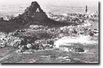 Pyramid Rock is a residual of basalt (A) overlying Woolamai Granite (arrowed), Site 193 |
| Access: | Pyramid Road. Pyramid rock is accessible only by boat or a hazardous swim. | |
| Ownership: | Crown land and a small area of private land. | |
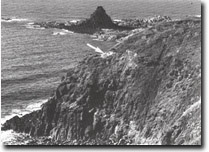
| Geology: | Pyramid Rock is a remnant of a lava flow resting on a basement of Woolamai Granite. At low tide there is an extensive area of granite exposed, the largest outcrop of this material outside Cape Woolamai. The basalt is surrounded by an apron of coarse scree and gravel beaches, the dark colour of this material contrasting with the lighter coloured granite. This is one of the few locations on Phillip Island where the lava flows are absent or very thin and represents a high point on the pre-volcanic land surface. In the cliffs above Storm Bay the base of the basalt is also seen resting on a weathered granite surface and a granitic gravel. Thin beds of a clayey gravel also occur between the lava flows here. North of Storm Bay is an active amphitheatre 100 m wide and to the west are active bowl-shaped slumps at the plateau margin. | |
| Significance: | State. This is the best exposure of the base of the Older Volcanics on Phillip Island and a major example of the contact between the volcanics and the pre-volcanic land surface. The presence of inter-volcanic gravels indicates the Woolamai Granite was probably never completely covered by lava flows. The amphitheatre described is the most actively developing such feature on Phillip Island. | |
| Management: | Class 2. No extension to roads or car parks at the site should be permitted. The footpath to the lookout at the south of the point should be maintained to reduce the degradation of the cliff faces that show the sub-basaltic and inter-basaltic gravels. The amphitheatre should not be used as a rubbish tip. | |
| References: | Edwards, A.B. (1945). Tertiary dykes and volcanic necks of South Gippsland, Victoria. Proc. Roy. Soc. Vic. 4 (1) 59-62. Jenkin, J.J. (1962). The geology and hydrogeology of the Westernport area. Dept. of Mines Vict. Underground Water Investgation Report No. 5. | |
 Granitic gravels (arrowed) are intercalated between the basalt flows near Pyramid Rock, Site 193 |

© State of Victoria (Agriculture Victoria) 1996 - .

This work, Victorian Resources Online, is licensed under a Creative Commons Attribution 4.0 licence. You are free to re-use the work under that licence, on the condition that you credit the State of Victoria (Agriculture Victoria) as author, indicate if changes were made and comply with the other licence terms.
The licence does not apply to ‘branding’ or some ‘images or photographs’ that may be owned by third parties. We ask you to seek prior approval to use images using the VRO feedback form. Access to higher quality images can also be provided on request.
This page was last updated on .