
207. The Pinnacles - High Sand Ridge
|
This information has been developed from one or more of these publications:
|
Location: | Barrallier - 520528. 3 km north-east of Tankerton. | 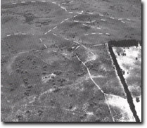 The Pinnacles showing the crescent form of the main ridges. Ridge crests shown by dotted lines, Site 207. |
Access: | A sandy vehicle track to The Pinnacles extends to the west from Clump Road, 2 km north of the Clump Road - Tankerton Road junction. | |
Ownership: | Crown land. | |
Geology/Geomorphology: | At The Pinnacles, the second highest point on French Island, there is a large accumulation of aeolian sands (Cranbourne Sand) in the form of high dunes. The crest of the dunes rises over 60 m in elevation and about 30 m above the floor of the neighbouring swales. This area contrasts markedly with the generally flat-lying subdued north-east - south-west ridge topography developed in the aeolian sands to the north of the Tankerton Fault. Jenkin (1962) has interpreted the unusual height of the dunes of The Pinnacles as due to an accumulation of sands because of the impeding effect of the Tankerton Fault scarp. | |
| The morphology of the dune crests in The Pinnacles area differs from the generally linear trend of the aeolian ridges to the north. It is possible that the crescent form of The Pinnacles is due to a reworking of mobile sands by south-westerly winds during the period when the waters of Westernport Bay isolated the dunes from their main source of sediment before the dunes were stabilized by vegetation. | ||
Significance: | State. The unusual height, thickness of aeolian sands and morphology of The Pinnacles area, makes this site unique within the Westernport Bay Catchment. The majority of similar dune deposits on the mainland are intensively cultivated and this area is a major example of relatively undisturbed Cranbourne Sand terrain. | |
Management: | Class 1. In order to preserve the configuration of these aeolian deposits it is strongly recommended that no quarrying, or modifications to dune morphology by roadworks, clearing, grading or cultivation be permitted. | |
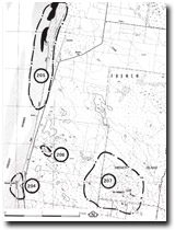 Site 205 to 207, North of Tankerton |

© State of Victoria (Agriculture Victoria) 1996 - .

This work, Victorian Resources Online, is licensed under a Creative Commons Attribution 4.0 licence. You are free to re-use the work under that licence, on the condition that you credit the State of Victoria (Agriculture Victoria) as author, indicate if changes were made and comply with the other licence terms.
The licence does not apply to ‘branding’ or some ‘images or photographs’ that may be owned by third parties. We ask you to seek prior approval to use images using the VRO feedback form. Access to higher quality images can also be provided on request.
This page was last updated on .