
PP65. Pelican Point - Cliff and Raised Platform
|
This information has been developed from one or more of these publications:
|
| Location: | 324740. Coastal cliff and platform at Pelican Point, Mt Eliza. | 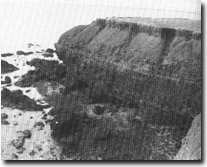 Site 65. Pelican Point |
Access: | Daveys Bay Road. | |
Ownership/Managing Authority: | Crown land, City of Frankston. | |
Site Description: | Pelican Point is an unusual cliff with a strongly convex profile in red Baxter Formation sandstone. The sandstone is strongly ferruginized and displays cross bedding and honeycomb weathering. The base of the cliff is undercut in places, but the cliff is relatively stable due to the strength of the ferruginous sandstone in the middle sector of the cliff profile. There is a wide, rough-surfaced shore platform with large blocks of sandstone and a coarse gravel beach. Galeolaria is prominent on the larger seaward blocks. On the southern side of the point there are several benches above high water level with residual rounded gravels 1.5 m above present high water mark that have the superficial appearance of higher level shore platforms. At the cliff top is a thick and well preserved shell midden. | |
Significance: | State. This is an unusually stable cliff form in Port Phillip Bay. In contrast to other cliffed sectors developed in Tertiary sediments on the Mornington Peninsula, in the Black Rock area and on the Bellarine Peninsula, these cliffs are of a cemented sandstone with minimal clays and do not develop rills and gullies and are not subject to slumping and rotational slipping. The site is easily and safety accessible for educational groups and presents an important control site to monitor process of cliff and platform development. The bench complex at the south of the site is an important locality to evaluate the sea level history of the eastern coast of Port Phillip Bay. The shell midden could form the basis of an educational display at the site. | |
Management Considerations: | Class 1. The cliffs should be maintained as active coastal landforms. No protective structures should be built at the base. A formalised footpath through the cliff top heath leading to the southern shores of the cliffs would improve access and reduce accidental damage to vegetation. This path should avoid traversing the boulder beds on the raised platform surfaces. An integrated management programme is required for the site. | |
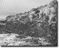 Site 65. 'Raised platforms', Pelican Point | |

© State of Victoria (Agriculture Victoria) 1996 - .

This work, Victorian Resources Online, is licensed under a Creative Commons Attribution 4.0 licence. You are free to re-use the work under that licence, on the condition that you credit the State of Victoria (Agriculture Victoria) as author, indicate if changes were made and comply with the other licence terms.
The licence does not apply to ‘branding’ or some ‘images or photographs’ that may be owned by third parties. We ask you to seek prior approval to use images using the VRO feedback form. Access to higher quality images can also be provided on request.
This page was last updated on .