
201. Palmer Point - Sand Ridges
|
This information has been developed from one or more of these publications:
|
Location: | Palmer - 645583. The north-east coastal sector of French Island. | 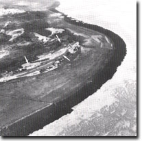 Older sand ridges (arrowed) behind a broad saltmarsh and mangrove fringe at Palmer Point, Site 201. |
Access: | Causeway Road to a fenceline and then sandy vehicle tracks to various parts of the area. | |
Ownership: | Private land and Crown land. | |
Geology/Geomorphology: | At Palmer Point, older coastal ridges have been isolated from marine activity by the development of a broad terrace of mangrove-fringed salt marsh. The configuration of the ridges indicates that the shoreline of French Island in the period preceding salt marsh formation was formerly sandy. The ridges at Palmer Point exhibit the morphology of a cuspate foreland and provide evidence of a significant change in the sediment regime of this sector of Westernport Bay (Kraemers 1975). The ridges have been deposited in front of a former sea-cliff, now a bluff, cut during the Pleistocene into downwash deposits. The isolation of these ridge deposits from marine action may indicate a slight fall in sea level during the Holocene period which exposed a large inter-tidal area upon which salt marsh developed. An alternative hypothesis favours the view that the development of a broad salt marsh zone represents a prograding shoreline feature which can form without the prerequisite of a fall in sea level. Detailed investigations of similar ‘stranded’ shoreline features in other parts of Westernport Bay is required before either hypothesis can be discarded. | |
Significance: | State. The site is of major importance to display a relict geomorphological process. The well-preserved relict features, in combination with present-day modifications to shoreline features in areas where mangroves have been removed, contribute to the diversity of the area. It is one of an important network of sites in the Westernport area that contribute substantial evidence concerning Holocene sea levels. In an historical sense, the Palmer Point area is important because of the well preserved remains of a salt-works established on the salt marsh during the 1880s. The clarity of these excavations indicates the stability of the salt marsh zone when its mangrove fringe remains intact. | |
Management: | Class 1. To maintain the significance of the site it is important that the configuration of the ridges at Palmer Point is not disturbed, and physical alteration of the ridges by quarrying, road construction or grading should be prohibited. To maintain the stability of the shoreline it is strongly recommended that no further access sites be cut through the mangrove fringe. | |
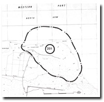 Site 201, Palmer Point |

© State of Victoria (Agriculture Victoria) 1996 - .

This work, Victorian Resources Online, is licensed under a Creative Commons Attribution 4.0 licence. You are free to re-use the work under that licence, on the condition that you credit the State of Victoria (Agriculture Victoria) as author, indicate if changes were made and comply with the other licence terms.
The licence does not apply to ‘branding’ or some ‘images or photographs’ that may be owned by third parties. We ask you to seek prior approval to use images using the VRO feedback form. Access to higher quality images can also be provided on request.
This page was last updated on .